Chesuncook, Maine facts for kids
Quick facts for kids |
|
|
Chesuncook Village
|
|

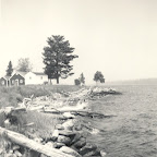
Photo c. 1964
|
|
| Location | NW Shore, Chesuncook Lake, Piscataquis County, Maine |
|---|---|
| Area | 560 acres (230 ha) |
| Built | 1849 |
| NRHP reference No. | 73000262 |
| Added to NRHP | April 11, 1973 |
Chesuncook is a small, quiet settlement located on the northwestern shore of Chesuncook Lake in rural central Piscataquis County, Maine. It's a place surrounded by nature, far from big cities. For a long time, Chesuncook was important for the logging industry, where people cut down trees and floated them down the river. Even famous writer Henry David Thoreau visited and wrote about it in his book, The Maine Woods. Today, Chesuncook is mostly a seasonal spot. This means people visit or live there mainly during certain times of the year, especially those who love outdoor activities like fishing, hiking, and exploring the wilderness. Seven important historic buildings in the village were added to the National Register of Historic Places in 1973.
Contents
The Story of Chesuncook Village
Chesuncook Village sits on the northwestern shore of Chesuncook Lake. It is close to where the West Branch Penobscot River flows into the lake. Getting there means a drive of about 60 miles (97 km) on mostly gravel roads from Millinocket.
Early Days and Logging
Long ago, this area was a camp for the Abenaki people, a Native American tribe. In the 1840s, Chesuncook started to grow as a village for loggers. This happened after a dam was built on the river. The dam made the lake bigger, which helped loggers float trees downstream more easily.
In 1853, Henry David Thoreau visited Chesuncook. He wrote that the village had "quite a harbor," meaning it was a good place for boats. The oldest house that survived in the village was the Chesuncook Lake House. It was built in 1864. This building served as a place for loggers and visitors to stay.
Growth and Change
Over the next few decades, the village continued to grow. By 1900, about 65 people lived there. By 1920, the population had grown to about 250. However, things changed for logging in the region. A new dam, called the Ripogenus Dam, was built in 1916. This dam changed how logs were moved down the river. Because of these changes, the village of Chesuncook became smaller during the 20th century. Sadly, the Chesuncook Lake House, a very old and important building, burned down on March 17, 2018.
Village Buildings and Features
Besides the Chesuncook Lake House, there are other smaller summer houses along the waterfront. These houses stretch north towards a place called Graveyard Point. At Graveyard Point, you can find some buildings that were built by the Great Northern Paper Company. These buildings provided homes for their workers.
A little way inland from the lake, there is a special building that was both a church and a school. The Great Northern Paper Company also built this. It is located near the village cemetery. The cemetery was originally at Graveyard Point. But it had to be moved when the 1916 dam raised the water level of the lake.


