Christchurch Railway Cycleway facts for kids
Quick facts for kids Christchurch Railway Cycleway |
|
|---|---|

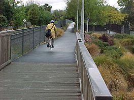
Pathway south of Wairakei Road
|
|
| Length | 6 km (3.7 mi) |
| Location | Christchurch, New Zealand |
| Trailheads | Kilmarnock Street (south) / Tuckers Road (north) |
| Use | Walking Cycling |
| Elevation gain/loss | nil |
| Difficulty | Easy |
| Season | Year round |
The Christchurch Railway Cycleway is a special path in Christchurch, New Zealand. It follows alongside the Main North railway line. This path is great for both walking and cycling.
The cycleway starts at Kilmarnock Street in Riccarton in the south. It goes through areas like Fendalton and Papanui. The path ends at Tuckers Road in Northcote in the north. The very northern part of the path was finished in 2010. When it was completed, the whole pathway was about 6 kilometers (almost 4 miles) long.
Contents
Exploring the Pathway
What the Path is Like
The Christchurch Railway Cycleway follows the route of an active railway line. This means you might see trains go by! The path is mostly flat, so it's easy to walk or ride on. Its width changes a bit, from about 1.8 meters (6 feet) to 3.5 meters (11.5 feet) wide. This depends on how much space was available when it was built.
Even though it's called a "cycleway," it's a shared path. This means people can walk, run, or cycle on it. It connects many important places. For example, it links schools like Papanui High School and Waimairi School. It also connects to local shops in Papanui and Strowan. The path is a safe way for people to travel from the northern parts of Christchurch to Riccarton and the city center.
Crossing Roads Safely
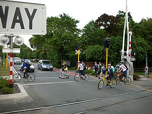
When the main part of the pathway was built, special care was taken for road crossings. Some busy roads needed traffic lights to help people cross safely. These roads include Fendalton Road, Wairakei Road, and Glandovey Road. Later, Blighs Road also got traffic lights. When the path was extended to Tuckers Road in 2010, a new traffic light crossing was added at Northcote Road.
These special crossings have bicycle detectors. These detectors are placed on the path before you reach the intersection. This means that as you ride up, the lights can change to green for you. This helps cyclists and walkers cross the roads smoothly and safely.
Future Plans for the Path
There are exciting plans to make the pathway even longer! To the north, there are ideas to extend it from Tuckers Road to Main North Road. This extension was planned before the big earthquakes in Canterbury. There are also studies looking into extending the path all the way to Belfast. It might even connect to new highway routes.
To the south, plans are in place to continue the pathway through Riccarton. It would cross Riccarton Road and go towards Blenheim Road. The path would eventually reach the Christchurch railway station. In the future, the city hopes to connect this pathway with other paths along different railway lines. This would create a big network of safe paths for everyone to use.
 | Selma Burke |
 | Pauline Powell Burns |
 | Frederick J. Brown |
 | Robert Blackburn |


