
Chu (river) facts for kids
Quick facts for kids Chu |
|
|---|---|

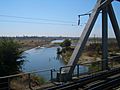
In the Chüy Valley below Tokmok
|
|


|
|
| Native name | |
| Country | Kyrgyzstan, Kazakhstan |
| Physical characteristics | |
| Main source | Confluence of Joon Aryk and Kochkor Kochkor District, Naryn Region, Kyrgyzstan 1,802 m (5,912 ft) 42°13′15.60″N 75°44′29″E / 42.2210000°N 75.74139°E |
| River mouth | Ashchykol Depression Turkistan Region, Kazakhstan 135 m (443 ft) 44°59′N 67°43′E / 44.983°N 67.717°E |
| Length | 1,067 km (663 mi) |
| Basin features | |
| Basin size | 62,500 km2 (24,100 sq mi) |
| Tributaries |
|
The Chu River (also called Shu or Chüy) is an important river in Central Asia. It flows through northern Kyrgyzstan and southern Kazakhstan. The river is about 1,067 km (663 mi) long, making it one of the longest rivers in both countries.
For part of its journey, the Chu River forms the border between Kyrgyzstan and Kazakhstan. Many places are named after this river, including the Chüy Region in Kyrgyzstan, which is a busy area. The main street in Bishkek, Kyrgyzstan's capital, is called Chüy Avenue. There is also a city named Shu in Kazakhstan.
Contents
Where Does the Chu River Flow?
The Chu River starts where two smaller rivers, the Joon Aryk and the Kochkor, meet in the Naryn Region of Kyrgyzstan.
It flows very close to Issyk-Kul, a large lake, but it doesn't flow into or out of it. After this, the river turns northwest. It then passes through a narrow place called the Boom Gorge.
The Chüy Valley
After the Boom Gorge, the river enters the wide, flat Chüy Valley. This valley is home to Bishkek, the capital of Kyrgyzstan, and the city of Shu in Kazakhstan.
Farmers use a lot of the Chu River's water to grow crops. They send the water through a network of canals, like the Great Chüy Canal. This helps to water the rich, dark soil in the Chüy Valley on both sides of the river.
Journey Through Kazakhstan
As the Chu River continues, it forms the border between Kyrgyzstan and Kazakhstan for over 100 kilometers. Then, it flows entirely into Kazakhstan. Here, it runs along the northern edge of the Moiynkum Desert.
During years with a lot of rain, the river can reach a salt lake called Akzhaykyn. This lake is found in a large area of salt flats known as the Ashchykol Depression.
History of the Chu River Area
The area around the Chu River has a long and interesting history. Long ago, it was home to people called the Iranian Sughds. They spoke a language called Soghdian.
During the Middle Ages, this region was very important for trade and power. Two famous ancient cities were located here: Suyab, which was the capital of the Western Turkic Khaganate, and Balasagun, the capital of the Qara Khitai empire.
The Chu River could sometimes cause problems with floods. For example, in the winter of 1878, a lot of ice blocked the river near Tokmok. This caused a big flood that damaged the town. Because of this, the capital of the region was moved to Pishpek, which is now Bishkek.
Dams on the River
To control the river's flow and help with irrigation, two dams have been built:
- The dam at Orto-Tokoy Reservoir in Kyrgyzstan was built in 1957.
- The dam at Tasotkel Reservoir in Kazakhstan was built in 1974.
River Health and Monitoring
Scientists and government agencies keep a close eye on the Chu River's water quality.
- In Kyrgyzstan, the State Agency for Hydrometeorology checks the water regularly.
- In Kazakhstan, the Hydrometeorological Service (Kazhydromet) does the same.
Water Quality Reports
From 2004 to 2008, most of the Chu River's water in Kyrgyzstan was considered "Clean water." This means it had very low pollution. There was one spot where the water was sometimes "Moderately polluted."
In Kazakhstan, the water quality in the Jambyl Region was rated as "Moderately polluted" in 2008 and 2009. This was because some substances, like copper and certain chemicals, were found in amounts higher than allowed.
Rivers Flowing into the Chu
Many smaller rivers and canals flow into the Chu River. In Kyrgyzstan alone, there are almost 5,000! Here are some of the main ones:
- Kochkor (joins from the left)
- Joon Aryk (joins from the right)
- Chong-Kemin (joins from the right)
- Kichi-Kemin (joins from the right)
- Ysyk-Ata (joins from the left)
- Alamüdün (joins from the left)
- Ala-Archa (joins from the left)
- Ak-Suu (joins from the left)
- Kuragaty (joins from the left)
Images for kids
-
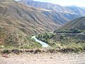
The Chu River in the Boom Gorge
-
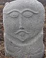
A medieval stone statue called a balbal near Burana Tower in the Chüy Valley
-
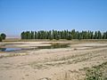
The Chüy Valley near Milyanfan
-
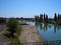
The Chu River near the Korday border crossing
-
The Chu River near Shu city in Kazakhstan
-
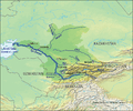
The Chu River shown within the larger Syr Darya basin


See also
- Chu-Ili Range
 In Spanish: Río Chu para niños
