Chuginadak Island facts for kids

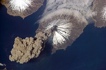
Mount Cleveland erupts in 2006. Taken from the International Space Station
|
|
| Geography | |
|---|---|
| Location | Aleutian Islands, Alaska, United States |
| Coordinates | 52°50′41″N 169°49′05″W / 52.84472°N 169.81806°W |
| Archipelago | Islands of Four Mountains |
| Area | 64 sq mi (170 km2) |
| Highest elevation | 5,676 ft (1,730 m) |
| Highest point | Mount Cleveland |
| Administration | |
|
United States
|
|
| Demographics | |
| Population | 0 |
Chuginadak Island is a cool, uninhabited island in the Aleutian Islands chain, way up in Alaska, United States. It's the biggest island in a group called the Islands of Four Mountains. Even though no people live here, it's famous for its giant, active volcano, Mount Cleveland, which takes up half the island!
Discovering Chuginadak Island
Chuginadak Island is part of the Aleutian Islands, a long chain of islands in Alaska. It is the largest island in the Islands of Four Mountains subgroup. This island is about 14 miles (22.5 km) long and 6 miles (9.6 km) wide.
What's in a Name?
The name "Chuginadak" comes from the Aleut language. It was first written on a map in 1852. The Aleut word "chugida-lix" means "to fry" or "to make sizzle." This name likely refers to the island's active volcano.
The western part of the island is called Chuginadax in Aleut. This name means 'simmering'. It also points to the hot, volcanic activity on the island.
Island Geography
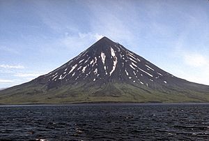
The western half of Chuginadak Island is almost entirely made up of Mount Cleveland. This mountain is a type of volcano called a stratovolcano. Stratovolcanoes are tall, cone-shaped volcanoes built up by many layers of hardened lava and ash.

A narrow strip of land connects this large volcano to the eastern side of the island. The eastern side is lower and more rugged.
The only major bay on the island is Applegate Cove. It is located on the northern coast and is about 2.5 miles (4 km) wide. This cove was named after Samuel Applegate. He was a surveyor who explored the area in the 1880s.
 | Kyle Baker |
 | Joseph Yoakum |
 | Laura Wheeler Waring |
 | Henry Ossawa Tanner |

