Mount Cleveland (Alaska) facts for kids
Quick facts for kids Mount Cleveland |
|
|---|---|

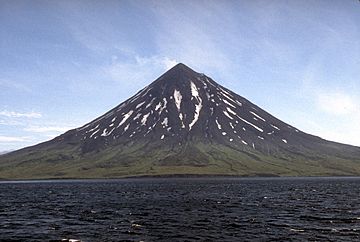
The nearly symmetrical face of Mount Cleveland, 1994
|
|
| Highest point | |
| Elevation | 5,675 ft (1,730 m) |
| Prominence | 5,675 ft (1,730 m) |
| Listing | |
| Geography | |
| Location | Chuginadak Island, Alaska, United States |
| Topo map | USGS Samalga Island |
| Geology | |
| Age of rock | Holocene |
| Mountain type | Stratovolcano |
| Volcanic arc/belt | Central Aleutian Arc |
| Last eruption | May 17, 2017 |
Mount Cleveland (also called Cleveland Volcano) is a tall, cone-shaped volcano in Alaska. It's located on Chuginadak Island, which is part of the Aleutian Islands. Mount Cleveland is about 5,675 feet (1,730 meters) high. It is one of the most active volcanoes in the Aleutian Arc, a chain of over 75 volcanoes.
The native Aleut people named the island "Chuginadak" after their fire goddess, who they believed lived inside the volcano. Later, in 1894, a team from the United States Coast and Geodetic Survey named the volcano Mount Cleveland. They named it after the president at that time, Grover Cleveland.
Mount Cleveland has erupted at least 22 times in the last 230 years. In 1944, an eruption caused the only known death from a volcano in the Aleutian Arc. More recently, it erupted several times between 2009 and 2017. Because the volcano is in a remote area, it's hard to study up close. The Alaska Volcano Observatory mostly uses satellites to watch it. The ash clouds from its eruptions can be dangerous for airplanes flying over the North Pacific Ocean. Volcanic ash can damage a plane's engines and electronic parts.
Contents
How Mount Cleveland Formed
Mount Cleveland is about 490 kilometers (300 miles) from the western end of the Aleutian Arc. This long chain of volcanoes stretches off the coast of Alaska. These volcanoes form where the Pacific Plate (a huge piece of Earth's crust) slides underneath the North American plate.
As the Pacific Plate goes deeper into the Earth, it gets hotter and more pressure builds up. This causes water and other substances to come out of the rocks. When this water mixes with the hot rock in the mantle (the layer below the Earth's crust), it lowers the melting point of the rock. This allows magma (molten rock) to form. The magma then rises to the surface, creating volcanoes like those in the Aleutian Arc.
The Name of Mount Cleveland
The native Aleut name for Mount Cleveland is Chuginadak. This name is now used for the whole island. It refers to the Aleut fire goddess, who was thought to live in the volcano. This name shows that the volcano has probably been very active for a long time.
Aleut stories say that the western and eastern parts of Chuginadak used to be separate islands. They believe that the narrow strip of land connecting them was formed by volcanic activity long ago. Russian mapmakers in the 1800s gave the name "Islands of Four Mountains" to this group of islands.
The volcano's current name, Mount Cleveland, was given in 1894 by a United States Coast and Geodetic Survey team. They were on the USS Concord ship when they saw it. Like other volcanoes in this group, which were named after important American politicians, Mount Cleveland was named after the president at the time, Grover Cleveland.
Shape and Location of Mount Cleveland

Mount Cleveland is a nearly symmetrical stratovolcano. This means it's a tall, cone-shaped volcano made of many layers of hardened lava, ash, and rock. It's part of the Islands of Four Mountains in the Aleutian Arc. Like all stratovolcanoes, Mount Cleveland grew layer by layer from explosive eruptions, lava flows, and mudslides (called lahars).
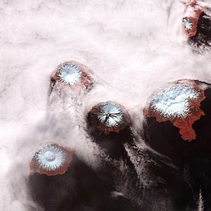
Mount Cleveland is the highest of the four volcanic islands in its group. It forms the western part of Chuginadak Island. The island is not inhabited by people. The closest town is Nikolski on Umnak Island, about 75 kilometers (47 miles) to the east.
The volcano is about 8 to 8.5 kilometers (5 to 5.3 miles) wide at its base. Its sides get much steeper as you go higher, from 19 degrees at the bottom to 35 degrees near the top. The lower parts of the volcano are rough, covered by many overlapping lava flows and rock piles. These lava flows are usually short and thin. Mount Cleveland is rarely completely covered in snow because its constant activity melts the snow. Scientists believe Mount Cleveland is a Holocene volcano, meaning it formed within the last 10,000 years.
All known eruptions have happened at the top of Mount Cleveland. However, there are at least five smaller volcanic domes (mound-shaped formations) on its lower sides. Sometimes, Cleveland has a lava dome at its summit. The volcano does not have a large caldera (a big basin formed when a volcano collapses).
The eastern part of Chuginadak Island is connected to Mount Cleveland by a narrow strip of land. This eastern part has several low volcanic cones and two taller peaks that have been worn down by glaciers.
History of Eruptions

Eruptions from Mount Cleveland are usually Vulcanian or Strombolian. This means they often involve short, explosive ash clouds. Sometimes, these are joined by lava flows, lava fountains, fast-moving flows of hot gas and rock (called pyroclastic flows), and steam. Lava domes can also grow at the summit, and hot rocks can be thrown out.
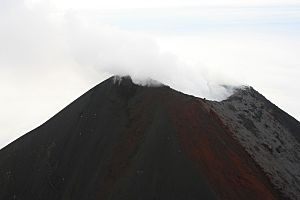
Hot springs were reported on the volcano in the 1800s. In the 1980s and 1990s, scientists saw constant steam vents (called fumaroles). Mount Cleveland always has some steam coming out and warm spots, showing it's always active. In 2011, a lava dome grew at the top, but several explosions later destroyed it. A new small dome was seen in June 2012.
Not much is known about Cleveland's early eruptions because it's so remote. Also, sometimes its eruptions were confused with those of nearby Mount Carlisle. The first confirmed eruption happened in 1828. Other possible or confirmed eruptions occurred in 1836, 1893, 1897, 1929, 1932, and 1938.
A significant eruption happened between June 10 and June 13, 1944. Lava flowed about 5 kilometers (3 miles) from the top, and an ash plume reached 6,000 meters (20,000 feet) high. Large rocks were reportedly thrown into the sea. Sadly, this eruption caused the only known death from a volcano in Alaska. A soldier who was stationed there went for a walk and never returned, likely killed by mudslides.
Mount Cleveland erupted more recently in 1951, 1953, 1954, 1975, 1984 to 1987, 1989, 1994, and 1997. It has received more attention lately because it has been more active. It erupted in 2001, 2005, three times in 2006, 2007, three times in 2009, and twice in 2010.
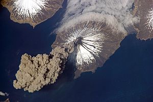
The 2001 eruption was very important. It created an ash plume 12 kilometers (7.5 miles) high. This plume spread 120 to 150 kilometers (75 to 93 miles) across Alaska. This was an unusual distance, allowing scientists to study it well with satellites. The town of Nikolski and nearby areas had ash falling for several hours. This eruption caused big problems for air traffic in the area.
On June 19, 2012, a pilot saw an ash-producing explosion. Because of ongoing ground shaking, the volcano was put on a "watch" list. The Alaska Volcano Observatory continues to watch Cleveland due to a hot spot at the summit, which might mean a lava dome is growing. Other small ash explosions happened on June 26, July 12, and August 19, 2012.
On May 4, 2013, the volcano began a small eruption, with an ash plume seen at 15,000 feet (4,600 meters). The volcano erupted several times in 2014 and 2015. A single explosion was detected on April 16, 2016. In total, the volcano has erupted at least 22 times in the last 230 years.
Monitoring Mount Cleveland
Today, the Alaska Volcano Observatory (AVO) uses satellite images to watch Mount Cleveland. Clouds often cover the volcano, making it hard to see what's happening. Also, satellite images don't always show small events. There are no earthquake sensors or other instruments directly on the mountain. Sometimes, pilots flying over the volcano are the first to report an eruption.
In 2001, scientists did a field study. After eruptions in 2005, an automatic system was set up to detect hot spots. In recent years, the AVO has worked to expand its volcano monitoring further west along the Aleutian Arc.
The biggest danger from a Mount Cleveland eruption is its ash plume. This ash can damage sensitive electronic equipment on planes flying overhead. Many planes traveling over the North Pacific and Arctic fly near the volcano. To avoid damage, flights must change their route. This causes delays and adds thousands of dollars in fuel costs. Because of this, the United States Geological Survey says Cleveland is a "volcano with a high aviation threat score." However, it does not have real-time ground monitoring right now.
See also
- In Spanish: Volcán Cleveland para niños
 | Madam C. J. Walker |
 | Janet Emerson Bashen |
 | Annie Turnbo Malone |
 | Maggie L. Walker |


