Nikolski, Alaska facts for kids
Quick facts for kids
Nikolski
Chalukax̂
|
|
|---|---|

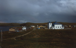
Houses and the St. Nicholas Russian Orthodox Church in Nikolski
|
|
| Country | United States |
| State | Alaska |
| Census Area | Aleutians West |
| Area | |
| • Total | 132.78 sq mi (343.91 km2) |
| • Land | 132.05 sq mi (342.01 km2) |
| • Water | 0.73 sq mi (1.90 km2) |
| Population
(2020)
|
|
| • Total | 39 |
| • Density | 0.30/sq mi (0.11/km2) |
| Time zone | UTC-9 (Alaska Standard (AKST)) |
| • Summer (DST) | UTC-8 (Alaska Daylight (AKDT)) |
| ZIP code |
99638
|
| Area code(s) | 907 |
| FIPS code | 02-54260 |
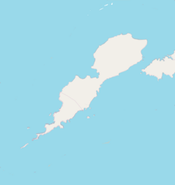
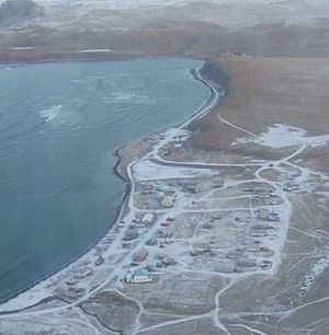
Nikolski is a small community located on Umnak Island in Alaska, United States. Its name in the local Aleut language is Chalukax̂. In 2020, only 39 people lived there. Nikolski is found on Nikolski Bay, at the southwest end of Umnak Island. It is about 116 air miles west of Unalaska. The people who live here are called Unangan, and many still speak the Aleut language.
Contents
History of Nikolski
Nikolski is believed to be one of the oldest places where people have continuously lived in the world. Scientists have found signs of human life on Ananiuliak Island, near Nikolski Bay, from about 8,500 years ago. Another site in Nikolski, called Chaluka, shows that people have lived there almost without stopping for 4,000 years.
How People Lived in Nikolski
For thousands of years, people in Nikolski have mainly gotten their food by fishing. They also raised sheep and cattle. In the 1800s, people also hunted sea otters and raised foxes for their fur. A large sheep ranch started in 1926, and today there are thousands of sheep on the island. In the early 1900s, the people bought a big fishing boat called the "Umnak Native," but it was unfortunately wrecked in 1933.
Nikolski During World War II
In June 1942, during World War II, Japanese forces attacked nearby islands. Because of this, the people of Umnak Island, including Nikolski, had to leave their homes. They were moved to the Ketchikan area in southeastern Alaska for safety. An American military base on Umnak Island helped fight off the Japanese. The people of Nikolski returned home in 1944. Many had seen the outside world for the first time. Since then, some have chosen to work in fish canneries or on fishing boats away from the island.
Later Developments in Nikolski
In the 1950s, the US Air Force built a special radar communication site near Nikolski. This site was called White Alice Communications System. However, it was no longer used after 1977. Today, Nikolski still has a gravel runway for planes, which is about 3,500 feet long. Planes bring passengers, mail, and cargo, but flights can be affected by the often harsh weather. Nikolski does not have a harbor for large boats.
Geography and Climate
Nikolski is located at coordinates 52°56′29″N 168°51′39″W / 52.941485°N 168.860765°W. The area of Nikolski is about 132.8 square miles (343.9 square kilometers). Most of this is land, with a small amount of water. The island has a maritime climate, meaning it's influenced by the ocean. Temperatures usually range from 11 degrees Fahrenheit (-11 degrees Celsius) to 65 degrees Fahrenheit (18 degrees Celsius). There is a lot of snow, especially on the mountains, and it often rains with strong winds. Summers can be foggy.
Mountains Near Nikolski
On a clear day, you can see Mount Vsevidof to the northeast from Nikolski. It is the highest point on Umnak Island, standing at 7,051 feet (2,149 meters) tall. Mount Vsevidof is an active volcano. Its last eruption was on March 11, 1957, after an earthquake. Another volcano, Mount Okmok, erupted in July 2008. This eruption greatly affected the people of Nikolski.
Time Zone Information
The border between the Alaska Time Zone and the Hawaii-Aleutian Time Zone is just west of Nikolski. This means Nikolski is officially in the Alaska Time Zone (UTC-9). However, because Nikolski is part of the Aleutian Region School District, the community actually follows Hawaii-Aleutian time (UTC-10).
Population Changes
| Historical population | |||
|---|---|---|---|
| Census | Pop. | %± | |
| 1880 | 127 | — | |
| 1890 | 94 | −26.0% | |
| 1920 | 83 | — | |
| 1930 | 109 | 31.3% | |
| 1940 | 97 | −11.0% | |
| 1950 | 64 | −34.0% | |
| 1960 | 92 | 43.8% | |
| 1970 | 57 | −38.0% | |
| 1980 | 50 | −12.3% | |
| 1990 | 35 | −30.0% | |
| 2000 | 39 | 11.4% | |
| 2010 | 18 | −53.8% | |
| 2020 | 39 | 116.7% | |
| U.S. Decennial Census | |||
Nikolski first appeared in the U.S. Census in 1880 as "Nikolsky," with 127 residents. Over the years, the population has changed. In 2000, there were 39 people living in 15 households. The population density was very low, meaning there were not many people living in a large area. In 2010, the population dropped to 18, but it increased again to 39 by 2020. The average age of people in Nikolski in 2000 was 40 years old.
Education in Nikolski
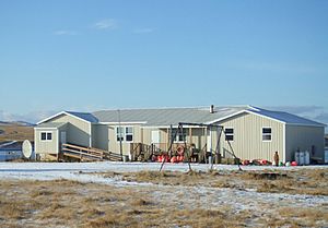
Nikolski was once served by the Aleutian Region Schools. The Nikolski School taught students from kindergarten through 12th grade. A teacher lived in a small house next to the school building. The school was built in 1939. In 1978, it had one teacher and 15 students.
Why the School Closed
In 2008, the number of students at Nikolski School fell below nine. In rural Alaska, schools usually need at least 10 students to get funding from the state government. The school district tried to keep the school open using its own money. A family from American Samoa moved to Nikolski, but they didn't have enough children to bring the student count up to 10. A student from another area was offered a chance to move to Nikolski to be the 10th student, but he chose not to. He wanted to take welding classes, which Nikolski School couldn't offer. Because the school couldn't reach 10 students, it closed after the 2009–2010 school year. After the school closed, some students left the village, while others were home schooled.
Media Appearances
Nikolski was partly featured in an episode of the TV show "Jeremy Wade's Dark Waters" in 2019. The show's host, Jeremy Wade, tried to catch large halibut fish offshore but couldn't. He also got stuck in Nikolski for several days because of bad weather.
See also
 In Spanish: Nikolski (Alaska) para niños


