Umnak facts for kids
Quick facts for kids
Umnak
|
|
|---|---|
|
Island
|
|
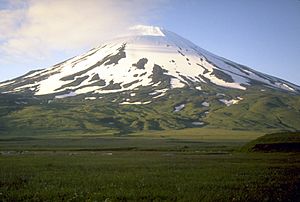
Highest point. Mount Vsevidof
|
|
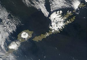
Satellite shot of Umnak and Unalaska Islands
|
|
| Country | United States |
| State | Alaska |
| Archipelago | Fox Islands of the Aleutian Islands |
| Area | |
| • Total | 686.01 sq mi (1,776.8 km2) |
| • Land | 686.01 sq mi (1,776.8 km2) |
| Highest elevation | 7,051 ft (2,149 m) |
| Population
(2000)
|
|
| • Total | 39 |
| • Density | 0.0569/sq mi (0.02195/km2) |
| ZIP code |
99638
|
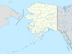
Umnak (Aleut: Unmax, Umnax; Russian: Умнак) is an island in the Fox Islands group, which is part of the Aleutian Islands. It covers about 686 square miles (1,777 square kilometers) of land. This makes it the third largest island in the Aleutian chain. It is also the 19th largest island in the entire United States.
Umnak Island is known for its large volcanic crater, called a caldera, on Mount Okmok. It also has the only area with geysers in Alaska. Umnak is separated from Unalaska Island by a narrow waterway called Umnak Pass. In 2000, only 39 people lived permanently on Umnak. By 2010, the population dropped to about 18. This made it hard for the small town of Nikolski, and its school eventually closed.
Contents
History of Umnak Island
The first known human settlement on Umnak Island is called Anangula. People lived there about 8,400 years ago. Later, Anangula was left empty. Other places like Sandy Beach, Idaliuk, and Chaluka became home to people. Most early settlements on Umnak were built near streams.
A big natural event happened between 8,250 and 3,000 years ago. Flat coastal areas, called strand flats, were formed. This change led to more natural food sources on the island for the people living there.
Russian Arrival and Conflicts
Russian fur traders first came to Umnak Island in the 1750s. The Russians treated the local Aleuts very badly. Because of this, the Aleuts in the Fox Islands formed an alliance. During the winter of 1761-1762, the crews of four Russian ships were attacked. One entire ship's crew on Umnak was completely killed.
Russian traders fought back in 1764. They used a harsh tactic, destroying everything in their path. This action effectively ended the Aleuts' independence.
Umnak During World War II
The modern history of Umnak Island is closely tied to the military bases built by the United States during World War II. These air bases in the Aleutian Islands had two main goals. They were meant to protect Dutch Harbor. They also served as places to launch attacks against the Japanese mainland.
The US Navy saw Umnak as their own special place. They set up a secret operation called "Blair Fish Packing Co." This was a cover to build airports and bases for the United States Army Air Forces. After getting approval, airbases were built at Umnak, later known as Fort Glenn, and at Cold Bay.
By the summer of 1942, when the Japanese attacked, the US forces at Umnak had about 4,000 soldiers. This included engineers, infantry, and artillery units. The Japanese planned to attack and take over Umnak in June. They wanted to use it to control the skies over the North Pacific. The Japanese did not know about the secret preparations made by the United States. They thought the island was only protected by a few ships.
Geography and Climate
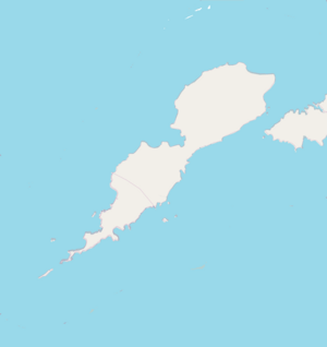
Umnak is the third largest of the Aleutian Islands. It is smaller than Unimak and Unalaska. It is located in the Fox Islands of the Aleutian Islands, in the Bering Sea. Umnak lies southwest of the larger island of Unalaska.
The island is about 70 to 72 miles (117 kilometers) long. It is about 16 miles (26 kilometers) wide on average. Umnak was separated from the mainland during the last ice age. It is now about 300 kilometers (186 miles) from North America.
Umnak is an active volcanic island. It has a land area of about 1,793 square kilometers (692 square miles). Its coastline stretches over 330 kilometers (205 miles). The island's highest point is 2,132 meters (6,995 feet) high. Umnak is very mountainous and does not have much plant life. The island does not have a natural harbor. However, there is a large bay in the western part of the island. This bay contains Adugak Island. The southern tip of Umnak is called Cape Sagak.
Volcanoes and Geysers
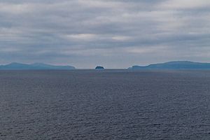
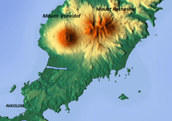
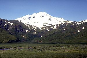
The highest peak on the island is Mount Vsevidof. This stratovolcano is in the southwestern part of Umnak. It has a cone shape that rises sharply from the land around it. At its top, it has a 1.2-kilometer (0.75-mile) wide crater. Its most recent eruption happened on March 11, 1957, after an earthquake.
East of Mount Vsevidof is the Russian Bay valley. Another stratovolcano, Mount Recheshnoi, is also there. It is 1,984 meters (6,509 feet) high. In the southwest, you can find the town of Nikolski. Southeast of Nikolski is Umnak Lake, which is just over 2 kilometers (1.2 miles) long. The ancient settlement of Chaluka is located between this lake and Nikolski. This area is known as the Samalga Pass. It was a center of ancient activity on the island.
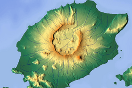
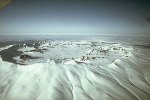
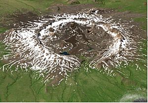
The northern part of the island has volcanic rocks. It features cracks in the ground, lava flows, and broken pieces of volcanic rock. Mount Okmok is in the northwestern part of the island. It has a large, circular caldera that is 5.8 miles (9.3 kilometers) wide. This flat central area is about 370 meters (1,214 feet) above sea level. The rim of the caldera reaches a height of 1,073 meters (3,520 feet).
After the caldera formed, many smaller cones and lava domes appeared on the volcano's sides. These include Mount Tulik and Mount Idak. A crater lake once filled much of the caldera. It was over 500 feet (152 meters) deep. But the lake eventually drained through a gap in the northeast rim. After the 2008 eruption, the water system inside the caldera changed a lot. Now there are five separate large lakes. The Alaska Volcano Observatory currently rates Okmok as a low-risk volcano.
North of Mount Recheshnoi, in the Geyser Creek valley, are geothermal fields with geysers. In 1988, there were 5 active geysers up to 2 meters (6.6 feet) high. There were also 9 natural fountains up to 0.7 meters (2.3 feet) high.
Umnak's Climate
Umnak has a subarctic climate. This means it has short, mild to warm summers. Winters are long, cold, and snowy. It is also close to a subpolar oceanic climate.
| Climate data for Umnak, Alaska | |||||||||||||
|---|---|---|---|---|---|---|---|---|---|---|---|---|---|
| Month | Jan | Feb | Mar | Apr | May | Jun | Jul | Aug | Sep | Oct | Nov | Dec | Year |
| Record high °F (°C) | 46 (8) |
49 (9) |
46 (8) |
50 (10) |
59 (15) |
64 (18) |
70 (21) |
74 (23) |
64 (18) |
60 (16) |
55 (13) |
46 (8) |
74 (23) |
| Mean daily maximum °F (°C) | 36.9 (2.7) |
33.2 (0.7) |
37.9 (3.3) |
40.6 (4.8) |
45.1 (7.3) |
50.0 (10.0) |
54.9 (12.7) |
55.6 (13.1) |
52.0 (11.1) |
44.9 (7.2) |
39.3 (4.1) |
36.8 (2.7) |
43.9 (6.6) |
| Daily mean °F (°C) | 33.3 (0.7) |
28.9 (−1.7) |
33.8 (1.0) |
36.2 (2.3) |
40.3 (4.6) |
45.2 (7.3) |
49.4 (9.7) |
50.1 (10.1) |
45.9 (7.7) |
39.9 (4.4) |
35.2 (1.8) |
32.4 (0.2) |
39.2 (4.0) |
| Mean daily minimum °F (°C) | 29.6 (−1.3) |
24.6 (−4.1) |
29.6 (−1.3) |
31.8 (−0.1) |
35.4 (1.9) |
40.3 (4.6) |
43.8 (6.6) |
44.7 (7.1) |
39.8 (4.3) |
33.8 (1.0) |
31.1 (−0.5) |
27.9 (−2.3) |
34.4 (1.3) |
| Record low °F (°C) | 8 (−13) |
10 (−12) |
8 (−13) |
18 (−8) |
24 (−4) |
30 (−1) |
34 (1) |
32 (0) |
26 (−3) |
18 (−8) |
20 (−7) |
16 (−9) |
8 (−13) |
| Average precipitation inches (mm) | 4.05 (103) |
1.86 (47) |
2.04 (52) |
2.00 (51) |
2.97 (75) |
2.37 (60) |
3.49 (89) |
5.40 (137) |
4.85 (123) |
5.78 (147) |
4.35 (110) |
2.87 (73) |
42.02 (1,067) |
| Average snowfall inches (cm) | 5.2 (13) |
12.0 (30) |
10.3 (26) |
4.9 (12) |
1.7 (4.3) |
0.0 (0.0) |
0.0 (0.0) |
0.0 (0.0) |
0.1 (0.25) |
2.9 (7.4) |
6.1 (15) |
9.6 (24) |
52.8 (134) |
Volcanic Eruptions on Umnak
On July 12, 2008, Mount Okmok on Umnak erupted. It sent a large cloud of ash and gas 50,000 feet (15,240 meters) into the air. This eruption lasted for several days. It forced people to leave Fort Glenn, a private cattle ranch on the island. Ash fell on the eastern part of Umnak. It also reached a fishing village 65 miles (105 kilometers) away to the northeast.
However, the Aleut village of Nikolski, on the opposite side of Umnak, was safe. The ash clouds moved southeast, away from the village. The ash plume also caused problems for flights to the Dutch Harbor airport. It spread across many miles of the North Pacific Ocean.
Past Eruptions of Okmok Caldera
The Okmok Caldera itself was formed by two major eruptions. These happened 12,000 and 2,000 years ago. People have been observing volcanic activity here since 1805. There have been 16 recorded eruptions, usually every 10 to 20 years.
The 1817 eruption covered the northeastern caldera rim with several feet of ash and rock. Ash also fell on Unalaska Island. Floods from this eruption destroyed an Aleut village at Cape Tanak. In the more recent 1997 eruption, ash clouds traveled 6 miles (10 kilometers) across the volcano's caldera floor.
Population and Community Life
In 1941, when the island was a military base, only about 50 Aleut people lived there. By the year 2000, the island's population had dropped to just 39 people. The only remaining community, Nikolski, was home to everyone on the island. Fort Glenn, a former large military base, was very important during World War II.
In 2000, there were 15 households and 12 families living on Umnak. The island had a very low population density. About 30.77% of the people were White, and 69.23% were Native American.
Of the 15 households, 40% had children under 18 living with them. More than half, 53.3%, were married couples. About 20% were single mothers, and 20% were not families. No one living alone was 65 years or older. The average household had 2.60 people, and the average family had 2.92 people.
In 2000, the average age of people on Umnak was 40 years old. About 35.9% were under 18. Most people were between 25 and 64 years old. For every 100 females, there were 105.3 males.
The average income for a household was $38,750. For a family, it was $40,250. Men generally earned more than women. The average income per person was $14,083. About 23.5% of families and 20.7% of the population lived below the poverty line. This included 13.6% of those under 18 and 55.6% of those over 64.
Education on Umnak
The only school on Umnak Island was in Nikolski. It was part of the Aleutian Region Schools. The Nikolski School taught students from kindergarten through 12th grade. The school had one teacher who lived in a small house next to the school. This house was owned by the school district and built for teachers.
The Nikolski School faced challenges to stay open. Schools in rural Alaska need at least 10 students to get money from the state. For the 2009–2010 school year, Nikolski School had only nine students. A family from Samoa who had students there later moved away. Because of this, the school was closed in 2010.
Transportation on Umnak
Umnak Island does not have a natural harbor. However, it does have an airstrip called Nikolski Airport. Building an airport runway in the island's hilly area was a big engineering challenge. Army Engineers, led by Colonel Benjamin B. Talley, designed it.
Construction of the runway began in mid-January 1942 at Otter Point. It was finished by April of the same year. The airport was named Fort Glenn. Workers assembled 300,000 square feet (27,871 square meters) of Marston Matting. This was a special perforated-steel plating (PSP). It created a flat surface for planes to take off and land. The runway was completed on March 31, 1942. It was 3,000 feet (914 meters) long and 100 feet (30 meters) wide. This was enough for Captain John S. Chennault's P-40 fighter aircraft to land.
The Naval Air Facility Otter Point was built right next to Fort Glenn.
After World War II ended, Fort Glenn stayed open. It was used as a place for planes to refuel in the Aleutians. It also served Military Air Transport Service flights from Japan to the United States. The main runway was made longer, to 8,300 feet (2,530 meters). This allowed larger, long-range aircraft to use it. By 1946, only a few staff members were left at the base. The last Army Air Forces personnel left by September 30, 1947. The base was then put on inactive status and was mostly abandoned. It was officially closed in 1950. The site was later given to the Bureau of Land Management. Many years later, the airfield was added to the National Register of Historic Places as Cape Field at Fort Glenn. The town of Nikolski still uses a gravel airstrip today.
See also
 In Spanish: Isla Umnak para niños
 | Lonnie Johnson |
 | Granville Woods |
 | Lewis Howard Latimer |
 | James West |


