
Mount Okmok facts for kids
Quick facts for kids Mount Okmok |
|
|---|---|

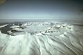
Aerial view looking across Okmok Caldera.
|
|
| Highest point | |
| Elevation | 3,519 ft (1,073 m) |
| Geography | |

Mount Okmok
Location in Umnak

Mount Okmok
Location in Alaska
|
|
| Location | Umnak Island, Aleutian Islands, Alaska, US |
| Topo map | USGS Umnak B-1 |
| Geology | |
| Mountain type | Shield volcano Complex with nested Caldera |
| Volcanic arc/belt | Aleutian Arc |
| Last eruption | July to August 2008 |
Mount Okmok is a large volcano located on Umnak Island in Alaska. It's part of the Aleutian Islands. The highest point of Mount Okmok is on the edge of a huge bowl-shaped area called the Okmok Caldera.
A caldera is a large crater that forms when the ground above a volcano's magma chamber collapses after a big eruption. The Okmok Caldera is about 9.3 kilometers (5.8 mi) wide. It sits on top of what used to be a very large shield volcano.
The Alaska Volcano Observatory watches Mount Okmok closely. Currently, it is at a "Green" Aviation Alert Level and a "Normal" Volcanic-alert Level. This means the volcano is not erupting and there are no immediate signs of unrest.
Contents
What Are Okmok's Crater Lakes Like?
Long ago, a large crater lake filled most of the Okmok Caldera. This lake was very deep, about 150 meters (490 ft) at its deepest point. It eventually drained out through a gap in the caldera's edge.
Today, there are still some smaller, shallow lakes inside the caldera. After a big eruption in 2008, the way water flows inside the caldera changed a lot. Now, there are five separate, good-sized lakes. Some of the smaller cones (mini-volcanoes) inside the caldera also have their own small crater lakes.
When Did Okmok Volcano Erupt?
Mount Okmok has had some very powerful eruptions in the past. Two of the biggest happened about 8,300 and 2,050 years ago. These were so strong they are rated as VEI 6 on the Volcanic Explosivity Index. This means they were "colossal" eruptions.
Scientists found volcanic ash from Okmok in ice cores from the Greenland ice cap. They discovered that a major eruption happened around 43-41 BCE. Experts think this eruption might have caused crop failures and hunger around the Mediterranean Sea. This could have affected important historical events, like the end of the Roman Republic and the rule of the Pharaohs in Egypt.
After the main caldera formed, many smaller cones and lava domes grew on the sides of the volcano. These include Mount Tulik and Mount Idak. Since 1805, Okmok has erupted at least seventeen times. One eruption of Mount Tulik was reported in 1936.
The Big Eruption of July 2008


On July 12, 2008, Okmok Caldera erupted suddenly. It sent a huge cloud of ash 50,000 feet (15,000 m) into the sky.

For the next five and a half days, the volcano erupted almost non-stop. People in nearby towns were affected. Flights were canceled, and ships couldn't pass through Umnak Pass. A cattle ranch near Okmok had to be evacuated several times because of heavy ashfall, which made it dark even at noon. The eruption finally stopped in August 2008. It was rated as a VEI 4, which is considered "cataclysmic."
This 2008 eruption came from a new vent in the northeast part of the caldera. It created a new cone about 800 feet tall. The eruption also changed the water systems inside the caldera and caused huge lahars (volcanic mudflows) that flowed from the caldera all the way to the coast. This 2008 event was the largest eruption at Okmok since at least the early 1200s.
Images for kids
-
Aerial view looking across Okmok Caldera.
-
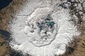
Okmok caldera from space in 2014.
-
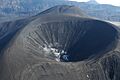
A new cone formed at Okmok Volcano after the 2008 eruption. (Photo by C. Neal, Alaska Volcano Observatory).
-
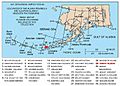
Map showing volcanoes of Alaska. Mount Okmok is marked on Umnak Island.
See also
 In Spanish: Monte Okmok para niños
