Church Charwelton (lost settlement) facts for kids
Quick facts for kids
Church Charwelton
|
|
|---|---|
|
Lost Settlement
|
|

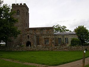
The isolated church
|
|
| Country | England |
| State | Northamptonshire |
| Region | East Midlands |
| District | Daventry |
| Municipality | Charwelton |
| Map Ref: SP544554 | |
Church Charwelton is a lost village in Northamptonshire, England. It used to be south-east of the modern village of Charwelton. You can find its old site near the River Cherwell. A long walking path called the Jurassic Way goes right through where the village once stood.
Why Did Church Charwelton Disappear?
People once thought Church Charwelton became empty during the Wars of the Roses in the 1400s. However, it's much more likely the village was abandoned because of changes in farming. This was called enclosure. Land that was once shared by many villagers was fenced off.
This change happened to make space for sheep farming. In 1417, Thomas Andrews bought land in the area. By 1547, his grandson, also named Thomas, had 1,200 sheep on the old village site. Another family, the Knightley family, also kept 300 sheep there.
Records show that the entire village site was empty by 1847. The old church of Charwelton still stands today. It is quite far from the modern village of Charwelton, showing where the old settlement used to be.
What Can We See Today?
You can still see the earthwork remains of the lost village. These are bumps and hollows in the ground. They are found to the south and south-east of the old church.
The easiest thing to spot is a hollow way. This is like an old, sunken road. It runs from north to south, starting near the River Cherwell and going up to the west of the church.
On both sides of this old road, you can see outlines of what were once small fields or yards. These are called closes. Sadly, much of this has been damaged by later farming. At the north end of the hollow way, you can clearly see where a house once stood. There are also several old medieval ponds around the site.
 | Delilah Pierce |
 | Gordon Parks |
 | Augusta Savage |
 | Charles Ethan Porter |


