
City Point, New Haven facts for kids
Quick facts for kids |
|
|
Oyster Point Historic District
|
|
 |
|

Location in Connecticut

Location in the United States
|
|
| Location | Roughly bounded by I-95, S. Water St., Howard Ave., Sea St., and Greenwich Ave., New Haven, Connecticut |
|---|---|
| Area | 26 acres (11 ha) |
| Built | 1939 |
| Architectural style | Late 19th and 20th Century Revivals, Greek Revival, Late Victorian |
| NRHP reference No. | 89001085 |
| Added to NRHP | August 10, 1989 |
City Point is a special area in New Haven, Connecticut. It used to be called Oyster Point. This part of the city is in the southwest, near the West River. Long ago, City Point was a narrow piece of land sticking out into New Haven Harbor. Over time, more land was added, making it wider. Today, I-95 cuts through it. The Oyster Point Historic District is a 26-acre area within City Point. It has many old buildings and is recognized for its history.
Contents
Exploring City Point's Borders
City Point has clear boundaries. To the west, you'll find the West River. Amtrak railroad tracks mark its northern edge. Hallock Avenue is on the east, and New Haven Harbor is to the south.
Some people used to think the northern border was the backyards of Lamberton Street. In the 1950s, I-95 (the Connecticut Turnpike) was built. This highway split the neighborhood in two. Because of this, some people started saying City Point was only the part south of the highway.
Most of the area south of I-95 is now called the Oyster Point Historic District. This name comes from the neighborhood's old name, Oyster Point. Another historic area, the Howard Avenue Historic District, is north of I-95. Newer buildings, like waterfront condos, are not part of any historic district.
How City Point Changed Over Time
City Point was once a peninsula, almost surrounded by water. New Haven Harbor was to its east and south. The West River wetlands were to its west.
In the 1800s and early 1900s, people in City Point made a living from the water. They harvested oysters and fished in New Haven Harbor. However, health authorities later stopped oyster harvesting.
Over the years, the land changed a lot. In 1929, the Boulevard was extended. The West River salt marsh began to be filled in. This area later became Kimberly Field, which has two baseball fields.
In the early 1900s, Second Street was extended. The first St. Peter Catholic Church was built. This church served the traditional City Point area. It also included nearby streets like Kimberly, Grant, Cassius, and Plymouth. So, people from these streets also felt they were part of City Point.
More land was filled in during the 1950s when I-95 was built. The eastern waters were replaced by a railroad yard and parking lots. Today, only the southern tip of City Point is next to the water. But if you look at a map, you can still see the original shape of the "point" in the street layout.
In 1978, the Boulevard was finally finished. A bridge was built over the railroad tracks. This connected lower Kimberly Avenue to the rest of The Hill neighborhood. By the end of the 1900s, the second St. Peter Church was taken down. Second Street went back to its original layout. Now, most people on Kimberly, Grant, Plymouth, and Cassius streets consider themselves part of the Kimberly Square neighborhood or The Hill.
Discovering the Oyster Point Historic District
The Oyster Point Historic District is a special part of City Point. It was added to the U.S. National Register of Historic Places in 1989. This means it's a place with important history.
The district covers 26 acres. It includes 130 buildings that show its historic character. There are also three other important structures. The district's borders were drawn to include old buildings and open spaces. Newer condo buildings by the water were not included.
From 1840 to 1925, this area was a busy oystering community. There used to be large tidal flats here. These were areas of mud or sand uncovered at low tide. But they have been reduced by filling in land and digging.
Today, the district is a close-knit neighborhood. You can see many "oystermen's houses" here. This is a unique style of home from the mid-1800s. There are also several Queen Anne style houses. When it was listed, the district had 108 homes built between 1840 and 1925.
The district also includes part of Bay View Park. This park was created in the 1890s. It has a monument honoring the Civil War. The park became smaller when I-95 was built through its middle. It is now 12 acres.
Places to See

- New Haven Harbor
- The Sound School
Gallery
-
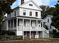
South Water St., City Point, contributing to Historic District.
-
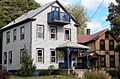
South Water St., City Point, contributing to Historic District.
-
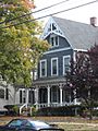
45 Howard Ave. (1870s), contributing to Historic District.
-
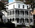
36-38 Howard Ave., contributing to Historic District.


