Ciudad de la Costa facts for kids
Quick facts for kids
Ciudad de la Costa
|
|
|---|---|
|
City and Municipality
|
|

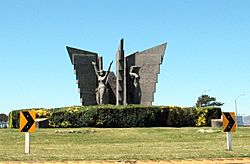
Monument in Ciudad de la Costa, by sculptor Bernabé Michelena
|
|
| Country | |
| Department | |
| Founded | 1994 |
| Area | |
| • City and Municipality | 51.25 km2 (19.79 sq mi) |
| • Urban | 57 km2 (22 sq mi) |
| Population
(2011 Census)
|
112,449 |
| • Density | 2,194/km2 (5,680/sq mi) |
| Time zone | UTC -3 |
| Postal codes |
15000 - 15008
|
| Dial plan | +598 2 (+7 digits) |
| Climate | Cfa |
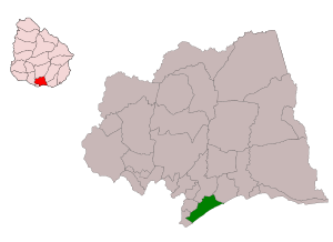
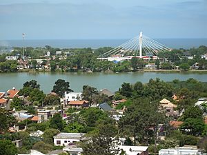
Ciudad de la Costa is a city in the Canelones Department of Uruguay. It sits along the Río de la Plata, a wide river that flows into the ocean. The city is located between two smaller rivers, Arroyo Carrasco and Arroyo Pando.
It's like a big suburb of Montevideo, Uruguay's capital, which is right next door to the west. To the east, it connects with another coastal area called Costa de Oro. Ciudad de la Costa officially became a city on October 19, 1994. In 2011, it was the second most populated city in Uruguay after Montevideo.
The name Ciudad de la Costa also refers to the larger area (municipality) that the city is part of. However, one small part, Barra de Carrasco, is not included in this municipality.
Contents
History of Ciudad de la Costa
This area was once known as "Rincón de Carrasco" in the 1800s. It has a long, sandy beach that stretches for about 16 kilometers (10 miles). Over time, in the 1900s, people started to settle here.
Many small vacation spots, or "resorts," grew up along the coast. These started from Barra de Carrasco in the west and went all the way to El Pinar in the east. For a long time, most people only visited these resorts in the summer or on weekends. The people who lived there all year often worked in Montevideo.
The area has a lot of sandy soil. This led to many sand pits, which later filled with water and became lakes. Some of these lakes are great for swimming and water sports. Others are important homes for many different kinds of birds and animals.
Population Growth
Since the 1980s, Ciudad de la Costa has grown very quickly. Many people moved here from Montevideo. In 1996, the population reached over 66,400 people. This was a huge increase of more than 92% compared to 1985.
As more people moved in, the different resorts started to blend together. This growth led to the area being declared a city. The population has continued to grow, though not as fast as before. By 2004, there were almost 84,000 residents.
Today, Ciudad de la Costa is the largest "satellite city" (a city that grew because of a nearby major city) in the Montevideo area. It is also one of the biggest cities in all of Uruguay.
In 2011, the official census counted about 95,176 people living in the neighborhoods that belong to the municipality. If you include a few other nearby areas, the total population could be even higher, around 112,447. This would make it the second-largest city in Uruguay.
Even with all this growth, the city still faces some challenges. For example, some areas don't have full public sanitation services. Also, many roads can become difficult to use when it rains a lot. Despite these issues, Ciudad de la Costa is an important place for business and tourism in Uruguay. The Carrasco International Airport is located just north of the city. The Autodromo Victor Borrat Fabini racetrack is to the east.
Geography and Climate
Weather in Ciudad de la Costa
Ciudad de la Costa has a humid subtropical climate. This means it has warm to hot and wet summers. The winters are mild, and rain falls fairly evenly throughout the year.
| Climate data for Ciudad de la Costa (Carrasco International Airport) 1991–2020, extremes 1951–2020 | |||||||||||||
|---|---|---|---|---|---|---|---|---|---|---|---|---|---|
| Month | Jan | Feb | Mar | Apr | May | Jun | Jul | Aug | Sep | Oct | Nov | Dec | Year |
| Record high °C (°F) | 39.6 (103.3) |
39.8 (103.6) |
37.0 (98.6) |
35.0 (95.0) |
31.9 (89.4) |
28.2 (82.8) |
29.8 (85.6) |
33.2 (91.8) |
34.3 (93.7) |
34.0 (93.2) |
37.7 (99.9) |
39.9 (103.8) |
39.9 (103.8) |
| Mean daily maximum °C (°F) | 27.3 (81.1) |
26.7 (80.1) |
25.2 (77.4) |
21.9 (71.4) |
18.5 (65.3) |
15.6 (60.1) |
14.5 (58.1) |
16.5 (61.7) |
17.6 (63.7) |
20.2 (68.4) |
23.2 (73.8) |
26.0 (78.8) |
21.1 (70.0) |
| Daily mean °C (°F) | 22.6 (72.7) |
22.3 (72.1) |
20.8 (69.4) |
17.7 (63.9) |
14.4 (57.9) |
11.5 (52.7) |
10.6 (51.1) |
12.1 (53.8) |
13.4 (56.1) |
16.0 (60.8) |
18.6 (65.5) |
21.2 (70.2) |
16.8 (62.2) |
| Mean daily minimum °C (°F) | 17.9 (64.2) |
17.9 (64.2) |
16.4 (61.5) |
13.5 (56.3) |
10.3 (50.5) |
7.4 (45.3) |
6.6 (43.9) |
7.7 (45.9) |
9.2 (48.6) |
11.7 (53.1) |
13.9 (57.0) |
16.3 (61.3) |
12.4 (54.3) |
| Record low °C (°F) | 7.6 (45.7) |
7.2 (45.0) |
6.2 (43.2) |
1.3 (34.3) |
−1.0 (30.2) |
−7.4 (18.7) |
−5.4 (22.3) |
−3.2 (26.2) |
−3.6 (25.5) |
1.5 (34.7) |
3.4 (38.1) |
6.5 (43.7) |
−7.4 (18.7) |
| Average precipitation mm (inches) | 93.1 (3.67) |
95.5 (3.76) |
112.3 (4.42) |
106.5 (4.19) |
87.8 (3.46) |
95.3 (3.75) |
96.5 (3.80) |
93.1 (3.67) |
92.6 (3.65) |
105.3 (4.15) |
92.4 (3.64) |
92.7 (3.65) |
1,163.1 (45.79) |
| Average precipitation days (≥ 1.0 mm) | 6 | 7 | 7 | 7 | 7 | 7 | 7 | 7 | 7 | 8 | 7 | 7 | 84 |
| Average relative humidity (%) | 68 | 71 | 74 | 75 | 78 | 79 | 78 | 75 | 74 | 72 | 70 | 68 | 73 |
| Mean monthly sunshine hours | 287.0 | 233.9 | 224.2 | 183.6 | 159.1 | 131.5 | 148.3 | 165.2 | 187.7 | 207.3 | 245.8 | 273.7 | 2,447.3 |
| Source 1: Instituto Uruguayo de Metereología | |||||||||||||
| Source 2: NOAA (precipitation and sun 1991–2020) Instituto Nacional de Investigación Agropecuaria (humidity 1980–2009) | |||||||||||||
Coastal Areas of Ciudad de la Costa
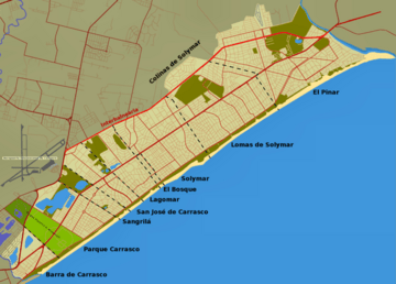
Ciudad de la Costa is made up of several coastal areas, or "resorts," that have grown together. Here are some of them and their populations from the 2011 census:
|
||||||||||||||||||||||||||||||||||
| Source: Instituto Nacional de Estadística de Uruguay |
The area known as Lomas de Solymar also includes smaller places like Parque de Solymar, Montes de Solymar, and Médanos de Solymar. Médanos de Solymar has its own postal code, 15007.
Other Areas Part of the City
The 2011 census also listed some non-coastal areas as part of Ciudad de la Costa. These areas are considered part of the city, but they are not part of the municipality of Ciudad de la Costa.
| Locality | Population |
|---|---|
| Paso de Carrasco | 15,908 |
| Lomas de Carrasco | 806 |
| La Asunción | 184 |
| Altos de la Tahona | 168 |
| Carmel | 80 |
| Haras del Lago | 68 |
| Quintas del Bosque | 57 |
Landmarks
North of the main highway, called Ruta Interbalnearia, you can find a private cemetery named Parque del Recuerdo.
See also
 In Spanish: Ciudad de la Costa para niños
 | Misty Copeland |
 | Raven Wilkinson |
 | Debra Austin |
 | Aesha Ash |


