Clarke's Gap facts for kids
Quick facts for kids Clarke's Gap |
|
|---|---|

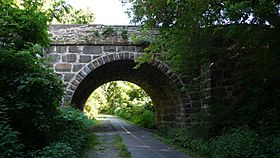
Stone bridge over Washington and Old Dominion Trail in Clarke's Gap in August 2008
|
|
| Elevation | 643 |
| Traversed by | Virginia Route 699 |
| Location | Loudoun County, Virginia, U.S. |
| Coordinates | 39°08′24″N 77°36′34″W / 39.14000°N 77.60944°W |
Clarke's Gap, also known as Clarks Gap, is a special opening through Catoctin Mountain in Virginia. It is located west of Leesburg, Virginia. A "gap" is like a low point or a pass that makes it easier to travel through mountains.
This gap is about 643 feet (196 meters) high. It's not a natural "wind gap," which is formed by wind and water over a long time. Instead, Clarke's Gap was mostly created by people. It's a railroad cut that goes through a low area between two higher parts of the mountain. This area was naturally shaped by small streams.
Contents
What is Clarke's Gap?
Clarke's Gap is a passage through the Catoctin Mountain range. It is found in Loudoun County, Virginia. The gap helps people and transportation cross the mountain. Its highest point is 643 feet above sea level.
Unlike many natural gaps, Clarke's Gap was made by humans. It was cut through a low spot in the mountain. This spot was naturally formed by water from nearby streams. These streams include Dry Mill Branch and a small part of Catoctin Creek.
How Was Clarke's Gap Formed?
A "gap" is a low point in a mountain range. It acts like a natural pathway. Clarke's Gap is unique because it's not a true "wind gap." A wind gap is a valley cut by an ancient river. Instead, Clarke's Gap is a "man-made" cut. This means people dug it out.
The gap was created for a railroad. It goes through a natural low spot. This low spot is called a "saddle point." It's like the dip between two hills. Water flowing from streams helped shape this area over time.
A Look Back: History of the Gap
Clarke's Gap has been an important travel route for a long time. In the mid-1700s, an early road passed through here. This road connected Alexandria to Winchester. It was known as Vestal's Gap or Braddock's Road.
How Clarke's Gap Got Its Name
In the 1860s, a railroad was built through the gap. This railroad was first called the Alexandria, Loudoun and Hampshire Railroad. It later became the Washington and Old Dominion Railroad. The railroad built a station at this spot.
They named the gap after a local landowner. His name was Addison H. Clarke. This is how Clarke's Gap got its official name.
Clarke's Gap Today
Today, Clarke's Gap is still a busy place for travel. A road called Dry Mill Road (Virginia State Route 699) uses the gap. The Washington and Old Dominion Trail also passes through it. This trail is popular for walking and biking.
Nearby Roads and Signs
Two other important roads, VA Route 7 and VA Route 9, pass near the gap. They go through a separate highway cut just north of Clarke's Gap. Sometimes, road signs mistakenly call this highway cut "Clarks Gap."
 | Percy Lavon Julian |
 | Katherine Johnson |
 | George Washington Carver |
 | Annie Easley |


