


- This page was last modified on 17 October 2025, at 11:18. Suggest an edit.
Washington & Old Dominion Railroad Regional Park facts for kids
| Washington & Old Dominion Railroad Trail | |
|---|---|

Stone arch at Clarke's Gap, August 2008
|
|
| Length | 44.7 mi (71.9 km) |
| Location | Virginia, United States |
| Trailheads | East: Shirlington in Arlington County West: Purcellville in Loudoun County |
| Use | Biking Horseback riding Running Hiking |
| Elevation change | 469 ft (143 m) |
| Highest point | Clarke's Gap, 610 ft (190 m) |
| Lowest point | Shirlington, 141 ft (43 m) |
| Difficulty | Easy |
| Season | All |
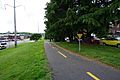
The Washington & Old Dominion Railroad Regional Park is a long, narrow park in Northern Virginia. Its main feature is the Washington & Old Dominion Railroad Trail (or W&OD Trail). This trail is paved with asphalt and follows the path of an old railroad that closed in 1968. It goes through busy cities, suburbs, and even quiet rural areas.
The park is about 44.8 miles (72.1 km) long, but only about 100 feet (30 m) wide. The paved trail itself is about 10 feet (3 m) wide. It's a shared use path, which means it's great for walking, running, cycling, and roller skating. For about 32 miles (51 km) on the western side of the park, there's also a separate bridle path made of crushed stone for horseback riding.
NOVA Parks (which used to be called the Northern Virginia Regional Park Authority) takes care of the park and its trails. They keep most of the land around the trails natural. Along the paved trail, you'll find mile markers and signs that tell you about the park's history and nature. The main office for the park is in Ashburn, and there's a rest stop nearby.
Contents
Trail Route and Journey
The W&OD Trail starts in the Nauck neighborhood of Arlington County, near the city of Alexandria. It ends in Purcellville in western Loudoun County. The trail mostly runs next to the Potomac River and Virginia State Route 7 (VA 7).
At its start, the W&OD Trail connects to the Four Mile Run Trail. This trail goes east through Arlington to the Mount Vernon Trail near Ronald Reagan Washington National Airport. You can also get to the start of the W&OD Trail from Interstate 395 (I-395).
The W&OD Trail runs alongside the Four Mile Run Trail in Arlington. They are usually on opposite sides of the stream. There aren't many restrooms or water fountains directly on the W&OD Trail in Arlington, but you can find them near ball fields and picnic areas along the Four Mile Run Trail.
The W&OD Trail begins at Mile 0, where South Shirlington Road meets South Four Mile Run Drive. This is the lowest point of the trail, at 141 feet (43 m) above sea level.
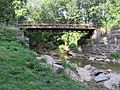
The trail then climbs 195 feet (59 m) over 5.9 miles (9.5 km) as it heads northwest through Arlington County. It crosses the Four Mile Run stream seven times using bridges built before the American Civil War.
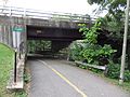
After crossing Columbia Pike (VA 244), the trail goes through a wooded area. It passes under Arlington Boulevard (U.S. Route 50).

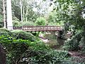
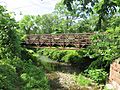
Bridge over Four Mile Run in Glencarlyn Park south of Arlington Boulevard (U.S. Route 50) (July 2020)
Further along, the trail meets the Bluemont Junction Trail, a 1.3-mile (2.1 km) paved trail that goes to Ballston. About 0.6 miles (1.0 km) after that, the W&OD Trail connects with the Custis Trail. This 4.5-mile (7.2 km) paved path runs along Interstate 66 (I-66) and can take you to Washington, D.C..
The W&OD Trail then travels near an I-66 sound wall for much of its way through Arlington. It also passes the East Falls Church station for the Washington Metro's Orange and Silver Lines.
The trail enters the Piedmont plateau region as it leaves Arlington. It keeps climbing northwest through the City of Falls Church and Fairfax County.
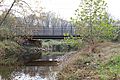
In Fairfax County, the trail reaches 450 feet (137 m) at its crossing of I-66. By this point, it has climbed 309 feet (94 m) over 8.4 miles (13.5 km). After crossing I-495 (the Capital Beltway) on a bridge and passing Dunn Loring, the trail starts to go downhill through Vienna. It continues to descend until it reaches Difficult Run (Mile 14.3), where it's at 240 feet (73 m) elevation.
After Difficult Run, the trail goes up and down as it crosses other streams like Sugarland Run, Broad Run, and Goose Creek. It passes through or near towns like Reston, Herndon, Sterling, Ashburn, and Leesburg. In Reston, it crosses Wiehle Avenue near the Wiehle–Reston East station of the Metro's Silver Line.
When the trail crosses Tuscarora Creek in Leesburg, it's at 273 feet (83 m) elevation. After that, it climbs 337 feet (103 m) over 6.3 miles (10.1 km) to reach its highest point: 610 feet (186 m). This highest point is on a bridge that carries VA 9 over VA 7 near Clarke's Gap. Just before this, the trail goes under an old stone arch that used to carry VA 7 over the old W&OD Railroad.
The trail then turns west, goes downhill through Paeonian Springs to Hamilton, and then climbs to Purcellville. When the trail ends in Purcellville, its elevation is 564 feet (172 m) above sea level.
Trail History
When the W&OD Railroad stopped running in 1968, its land stretched from Alexandria to Purcellville. The Virginia Department of Highways bought the land first, planning to use part of it for I-66. Later that same year, the Virginia Electric and Power Company (VEPCO), which had power lines along the railroad's path, bought most of the property.
The first part of the W&OD Trail opened in 1974 in Falls Church. It was a 1.5-mile (2.4 km) trail that became very popular. Because of this, NOVA Parks (then NVRPA) decided to buy the land from the power company between 1978 and 1982. The power company kept the right to maintain its power lines there.
NOVA Parks couldn't buy all the land, especially parts in Alexandria or where highways were planned. But they kept extending the trail. In 1979, the trail was extended 26 miles (42 km) westward from Falls Church to Goose Creek with help from a special grant. At first, only parts were paved, with other sections being just for hiking.
Over the years, more sections of the trail were paved. By 1981, it was paved from Vienna to Herndon. In 1982, a section from Herndon to Leesburg became a gravel path. Also in 1982, the trail was extended and paved eastward in Arlington. By the end of 1983, the easternmost section in Arlington was paved.
By 1988, the entire paved trail reached its western end in Purcellville. After that, NOVA Parks and the Virginia Department of Transportation (VDOT) worked on making improvements, like building bridges over busy roads so people on the trail wouldn't have to cross traffic. For example, a trail bridge was built over VA 28 in 1990, and another over West Broad Street (VA 7) in Falls Church in 1993.
In 2002, the last section of the trail was completed in Arlington's Bluemont Park. This part included a new bridge over Four Mile Run and an underpass below North Carlin Springs Road. In 2009, a connecting trail opened near the start of the W&OD Trail, linking it to the Four Mile Run Trail. In 2011, a new, wider, and taller bridge was built over I-495.
In 1987, the trail was named a National Recreation Trail. In 1999, the "Washington and Old Dominion Railroad Historic District" was recognized as important enough to be listed on the National Register of Historic Places because of its historical significance.
Historic Places Along the Trail
The park has many old structures, some from before the Civil War. Most are railroad remnants, like old stations in Vienna, Sunset Hills, Herndon, Hamilton, and Purcellville. You can also see stone arches, culverts, and parts of old bridges.
- Bluemont Junction Railroad Display: In Arlington, you can see part of a concrete floor from an old electrical substation built in 1912. This substation helped power the railroad's electric trains. A Southern Railway caboose here has photos and maps about the area's railroads.
- Coal Trestle Remnant: West of Lee Highway in Arlington, you can find a piece of an old coal trestle. This structure was once used to load coal onto trains.
- Mile Marker Post: Near the border of Arlington and Falls Church, there's a white metal post that says "Station 1 Mile." This post used to stand next to the railroad tracks.
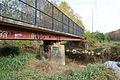
- Washington-Virginia Railway Bridge Abutments: Near Vienna, you can see the concrete base of a bridge that carried an old trolley line over the W&OD Railroad. It even has the date "July 1904" carved into it.
- Goose Creek Bridge: The trail crosses Goose Creek on a bridge built on the old piers and bases of the railroad's longest bridge. You can see these old parts if you leave the trail.
- Sycolin Creek Bridge: This bridge still has the only original span that carried W&OD trains. You need to leave the trail to see it.
- Tuscarora Creek Bridge: The piers and bases of this old railroad bridge are visible south of the trail near Leesburg.
- 19th-Century Lime Kiln: In Leesburg, you can see the remains of a 19th-century lime company. They burned limestone in a kiln to make quicklime for farmers and builders. You can see two arched openings where the quicklime came out.
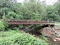
- Stone Arch at Clarke's Gap: A stone arch crosses over the trail near Clarke's Gap. Built around 1867-1868, it used to carry the original VA 7 road over the railroad tracks at the highest point of the line. Now, it carries Dry Mill Road (VA 699) over the trail.
Museums and Displays
The W&OD Trail has several places where you can learn more about its history:
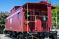
- Cabooses: Three cabooses have been donated and are on display. Two of them have exhibits about the W&OD Railroad and Trail.
- Bluemont Junction Railroad Display: In Arlington, a Southern Railway caboose (number X441) shows photos and maps about the local railroads. It's open on weekend afternoons from Memorial Day to Labor Day.
- Vienna Caboose and Museum: In Vienna Centennial Park, a caboose (numbered 503) has a museum with items the W&OD Railroad once used. It's open on some weekend afternoons.
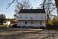
- Freeman Store and Museum: In Vienna, this store houses a museum about the town's history, including maps and books about the W&OD Railroad. It's open Wednesday through Sunday afternoons.
- Vienna W&OD Railroad Station: This station in Vienna has a museum and a model railroad display. It shows items from the W&OD Railroad and a model of the station. It's open one Saturday afternoon each month.
- Herndon Depot Museum: The W&OD Railroad station in Herndon is now the Herndon Depot Museum. It has photos and articles about Herndon and the railroad. It's open on Sundays from March to mid-December.
- Purcellville Train Station: This station is now the Loudoun Visitors Center. It has a W&OD Railroad display and hosts events. It's open on Saturdays and Sundays from late April through October.
- Luck Stone Quarry Overlook: East of Goose Creek, you can see a large trap rock quarry. This rock is used to make concrete and paving stones.
Nature and Wildlife
Most of the park is kept natural to protect green space and provide homes for wildlife. Some natural areas in the park connect to larger natural areas in nearby public parks, like the Sparrow Pond wetland in Arlington and the meeting point of Goose Creek and Sycolin Creek in Loudoun County.
The park is a great place for studying plants and animals. People have found about 450 types of wildflowers and over 100 kinds of birds here. You might see mammals like foxes, river otters, and beavers, or reptiles like turtles and snakes. Many types of hawks, owls, and other migratory birds also live in or visit the park.
Power Lines and Challenges
A set of electric power transmission lines runs above the W&OD Trail for part of its length. The power company sometimes removes trees along this section to protect its lines, which has caused protests from people and local leaders. Other parts of the trail are shaded by trees.
In 2004, the power company planned to extend these lines above ground in Loudoun County. Many people and local officials were against this. They worried about losing trees and the impact on the park. In 2007, a hearing recommended building the lines above ground. However, in 2008, the Virginia General Assembly passed a special law that required the company to build the lines underground in that section as part of a new program.
This underground project meant digging trenches on both sides of the trail. The W&OD Trail had to close for about a year in that area while the underground lines were installed. It reopened to the public in November 2010.
Future Plans for the Trail
NOVA Parks is looking into making the W&OD Trail wider or adding a second parallel trail in Falls Church and Arlington County because so many people use it, especially at busy times.
Falls Church and Arlington County
- Falls Church: In June 2018, NOVA Parks received a grant to expand a 1.2-mile (1.9 km) section of the trail in Falls Church. This project will create two separate paved paths: a 12-foot (3.7 m) wide path for bikes and an 8-foot (2.4 m) wide path for walkers, separated by a 2-foot (0.6 m) wide strip. This will make the trail much wider. Construction started in August 2020.
- Arlington County: In July 2020, NOVA Parks received a grant to study extending this expansion eastward into Arlington County for two miles.
- New Bridge in Arlington: The Virginia Department of Transportation (VDOT) is building a new bridge for walkers and bikers over U.S Route 29 (Lee Highway) in Arlington. This bridge is part of a larger highway project and is expected to be finished in February 2021.
Loudoun County
There have been ideas since the 1980s to extend the trail west to Bluemont and the Appalachian Trail. However, it's been hard to find a route and get the land needed. So, Loudoun County is now planning a new trail between Purcellville and Round Hill along VA 7 (Business).
The county has designed a 0.6-mile (1.0 km) multiuse trail that will connect Main Street in Round Hill to Franklin Park in Purcellville. Construction was expected to start in late summer 2020 and finish in late winter 2021. This section will connect to another planned trail that will go along West Main Street to connect Franklin Park and Purcellville.
Images for kids
Views along the W&OD Trail from east to west:
-
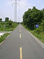
View west near South Four Mile Run Drive and start of W&OD Trail, Arlington County (May 2014)
-
View west near South Four Mile Run Drive, Arlington County (May 2014)
-
View northeast towards first W&OD Trail bridge over Four Mile Run in Glencarlyn Park, Arlington County (July 2017)
-
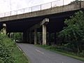
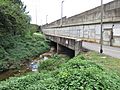
View northwest towards Arlington Boulevard (U.S. Route 50) bridge over the W&OD Trail and Four Mile Run, Arlington County (November 2019)
-
View northeast towards W&OD Trail bridge over Four Mile Run in Bluemont Park, Arlington County (July 2017)
-
View northeast towards W&OD Trail bridge over Four Mile Run in Bon Air Park, Arlington County (September 2017)
-
View west towards bridge over Four Mile Run connecting to N. Montana Street, Arlington County (September 2017)
-
View northwest towards N. Ohio Street bridge over Four Mile Run, the W&OD Trail and I-66, Arlington County (September 2017)
-
View northwest towards Four Mile Run culvert under the W&OD Trail and the I-66 sound wall, Arlington County (September 2017)
-
View southwest towards N. Sycamore Street bridge over the W&OD Trail and Four Mile Run, Arlington County (September 2017)
-
View north towards W&OD Trail bridge over Four Mile Run east of Little Falls Road, Arlington County (June 2020)
-

View southeast near trail crossing of Gallows Road, Dunn Loring, Fairfax County (April 2019)
-
View northwest towards concrete abutment of the bridge that carried the Washington-Virginia Railway over the W&OD Railroad near the east end of Vienna (December 2006)
-
View southeast towards Freeman Store, Vienna (November 2012)
-
View southwest towards bridge over Difficult Run east of Hunter Mill Road, Fairfax County (October 2020)
-

View southeast towards bridge over Difficult Run east of Hunter Mill Road, Fairfax County (October 2020)
-
View east towards bridge over Difficult Run east of Hunter Mill Road, Fairfax County (October 2020)
-
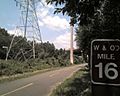
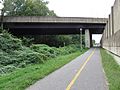
View northwest towards 16 Mile marker east of Dulles Access Road and Dulles Toll Road (VA Route 267) bridges over trail, Fairfax County (June 2008)
-

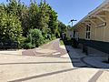
View northwest towards Herndon Depot, Herndon (August 2012)
-
View northwest towards caboose, Herndon (August 2012)
-
View northwest towards entrance to rest stop north of Smith Switch Road, Ashburn (August 2006)
-
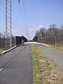
View northwest towards bridge over Claibourne Parkway, Ashburn (March 2012)
-
View northwest towards bridge over Claibourne Parkway, Ashburn (March 2012)
-

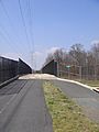
View northwest towards Belmont Ridge Road, Ashburn (March 2012)
-
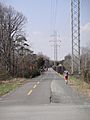
View northwest from the west side of Belmont Ridge Road, Ashburn (March 2012)
-
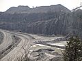
View south from Luck Stone Quarry overlook west of Ashburn (March 2012)
-

View northwest towards Cochrane Mill Road marker west of Ashburn (March 2012)
-
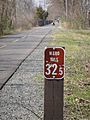
View northwest towards 32.5 mile marker in Leesburg (March 2012)
-

Stone bridge carrying Dry Mill Road over the W&OD Trail in Clarke's Gap (August 2008)
-
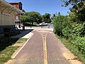
View west between North Maple Avenue and North Hatcher Street, Purcellville (August 2018)
-
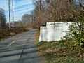
End of W&OD Trail in Purcellville, looking west toward North 21st Street (August 2018)
-
End of W&OD Trail in Purcellville, looking east from North 21st Street (August 2018)