Clarktown, Ohio facts for kids
Quick facts for kids
Clarktown, Ohio
|
|
|---|---|

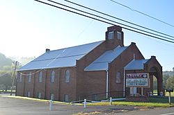
Baptist church on State Route 139
|
|

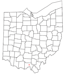
Location of Clarktown, Ohio
|
|
| Country | United States |
| State | Ohio |
| County | Scioto |
| Township | Jefferson |
| Elevation | 666 ft (203 m) |
| Population
(2020)
|
|
| • Total | 911 |
| Time zone | UTC-5 (Eastern (EST)) |
| • Summer (DST) | UTC-4 (EDT) |
| Area code(s) | 740, 220 |
| GNIS feature ID | 2633226 |
Clarktown is a small community in Scioto County, Ohio, United States. It is not an official city or town, but it is a "census-designated place" (CDP). This means the United States Census Bureau counts its population for statistics.
As of the 2020 census, about 911 people lived in Clarktown.
Where is Clarktown Located?
Clarktown is found in the southeastern part of Jefferson Township. It is right where State Route 139 meets Burns Hollow and Blue Run roads.
The community is about 5 miles (8 kilometers) southeast of Lucasville. It is also about 10 miles (16 kilometers) northeast of Portsmouth. Portsmouth is the main city and the "county seat" of Scioto County. A small stream called Long Run flows near Clarktown. This stream is a branch of the Little Scioto River.
See also
 In Spanish: Clarktown (Ohio) para niños
 | Bayard Rustin |
 | Jeannette Carter |
 | Jeremiah A. Brown |

