
Claude Chastillon facts for kids
.jpg)
Claude Chastillon (born around 1559 or 1560 – died 1616) was a talented French artist and engineer. He worked as an architect, a military engineer, and a civil engineer. He was also a draughtsman, meaning he drew detailed maps and pictures of places.
Claude Chastillon served under Henry IV of France, a famous French king. His most important work is a book called Topographie françoise. It was published after he died, in 1641. This book contains about 500 drawings of French towns and buildings. It's a special historical record of what France looked like in the early 1600s.
Life and Career
Claude Chastillon was born in a town called Châlons-en-Champagne in France.
In the 1580s, Claude Chastillon joined the army of Henry of Navarre. Henry of Navarre later became King Henry IV of France in 1589. In 1591, King Henry made Chastillon the Royal Topographer. This was a new and special job at the time. In 1595, he became a Royal Engineer. Royal Engineers were in charge of building military fortifications (strong defenses). They also worked on how to attack castles and manage water systems.
As part of his job, Chastillon traveled all over France and to nearby countries. He drew many pictures of the places he visited. These included towns, buildings, and old ruins. He started to have many of these drawings made into engravings. Engravings are pictures made by carving designs into a surface. Famous engravers like Mathieu Merian helped him.
Sadly, Claude Chastillon died in Paris in 1616. He passed away before he could publish most of his amazing collection of drawings.
Topographie françoise
About 15 years after Chastillon died, a publisher named Jean Boisseau bought his drawings. He also bought the metal plates used for the engravings. Boisseau hired other artists, like Isaac Briot and Nicolas Briot, to engrave the drawings that weren't finished.
In 1641, Boisseau published the collection as Topographie francoise. The full title was very long, but it's usually called Topographie françoise. The book gave credit to Chastillon for creating all the drawings. It offers a unique look at France in the early 1600s.
The book shows pictures of many important houses and castles. These belonged to officials and friends of the king. Many of these buildings no longer exist today. This makes Topographie françoise a very valuable source. It helps us learn about French noble homes from that time.

Later editions of the book had some mistakes. In the second edition, published in 1648, drawings by other artists were added. This edition also included new city maps. For example, it showed maps of Lunel, Montauban, and Montpellier. Some plates from this edition were even dated after 1641, even though the title page said 1641. One special drawing shows the Cordouan lighthouse. Chastillon had actually helped plan the completion of this lighthouse in 1606.
Louis Boissevin, another publisher, bought Topographie françoise from Boisseau. He published a third edition in 1655. In this edition, the pictures were put in alphabetical order. However, some pictures without titles were wrongly identified.
Some historians have questioned how accurate Topographie françoise is. This is because of the errors in later editions. Also, Chastillon's drawings sometimes made buildings look bigger than they were. The quality of some engravings was also not the best. Unfortunately, Chastillon's original drawings are now lost.
However, an expert named Françoise Boudon studied the work closely. She believes that Chastillon was very careful in his approach. He looked for the best viewpoints and measured distances. He also noted special features of the land and buildings. She says that these engravings are not just random pictures. Instead, they are a "precise report" on France in the early 17th century.
Topographie françoise is a very rare book today. Only about 15 copies of all its editions still exist.
Gallery
-
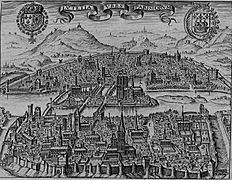
Paris around 1600
-
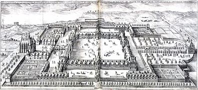
Hôpital Saint-Louis, 1608
-
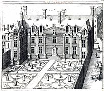
Hôtel d'Angoulême

.jpg)
.jpg)
See also
 In Spanish: Claude Chastillon para niños
