Coal Bluff, Indiana facts for kids
Quick facts for kids
Coal Bluff, Indiana
|
|
|---|---|

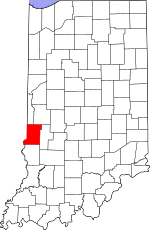
Vigo County's location in Indiana
|
|
| Country | United States |
| State | Indiana |
| County | Vigo |
| Township | Nevins |
| Elevation | 551 ft (168 m) |
| Time zone | UTC-5 (Eastern (EST)) |
| • Summer (DST) | UTC-4 (EDT) |
| ZIP code |
47874
|
| Area code(s) | 812 |
| GNIS feature ID | 449640 |
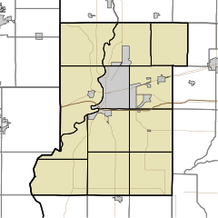
Coal Bluff is a small, unincorporated community in northern Nevins Township, Vigo County, in the U.S. state of Indiana. This means it's a group of homes and businesses that isn't officially a town or city with its own local government. It is part of the larger Terre Haute metropolitan area.
Contents
History of Coal Bluff
Coal Bluff started as a small settlement because of a coal mine opened by someone named Webster. This was one of the very first coal mines in Vigo County. Webster later sold the mine to a group called the Coal Bluff Mining Company. This is how the community got its name, "Coal Bluff."
From Mining Town to Residential Area
In the year 1890, Coal Bluff was mostly a mining town. It had its own post office and a railroad station. About 176 people lived there at that time. After the coal mines closed down, Coal Bluff changed. Today, it is mainly a place where people live.
The mail for Coal Bluff now comes from Rosedale, Indiana. Telephone numbers for the area are from Clay County. There are also farms in the surrounding area, and some families have lived there for a long time.
Post Office Operations
A post office was first opened in Coal Bluff in 1876. It served the community for many years. However, the post office eventually closed down in 1969.
Geography of Coal Bluff
Coal Bluff is located at 39°34′58″N 87°13′12″W / 39.58278°N 87.22000°W. This location is about 554 feet (or 168 meters) above sea level.
 | Percy Lavon Julian |
 | Katherine Johnson |
 | George Washington Carver |
 | Annie Easley |


