Codorus Navigation facts for kids
Quick facts for kids Codorus Navigation |
|
|---|---|

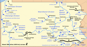
Map of historic Pennsylvania canals and connecting railroads
|
|
| Specifications | |
| Locks | 13 |
| Status | Abandoned except for recreation and historic interest |
| History | |
| Original owner | Codorus Navigation Company |
| Date of first use | 1832 |
| Date completed | 1833 |
| Date closed | ~1850 |
| Geography | |
| Start point | York |
| End point | Susquehanna River at the mouth of Codorus Creek |
| Connects to | Susquehanna River |
The Codorus Navigation was a special waterway built in south-central Pennsylvania. A company in York started it in 1829. Their goal was to create a way for boats to travel along Codorus Creek. This waterway stretched about 11 miles (18 km) from York to the Susquehanna River.
The plan for the Codorus Navigation included a mix of different parts. About 3 miles (4.8 km) of it was a true canal. The rest, about 8 miles (13 km), used "slack-water pools." These were calm sections of the creek made deeper by building 10 dams. To help boats move between different water levels, 13 locks were built. Each lock lifted or lowered boats by about 7 feet (2.1 m).
Building and Using the Waterway
The first part of the system, about 3 miles (4.8 km) long, was finished in 1832. This allowed two boats, named Codorus and Pioneer, to offer fun trips for passengers. They traveled between York and Barnitz's Springs.
The entire waterway was ready for boats, arks (a type of flat-bottomed river boat), and rafts by 1833. The very first ark to reach York carried a huge amount of lumber, about 40,000 cubic feet (1,100 m³). It also carried 100 passengers! Later, boats brought other goods like stone, coal, and shingles to York.
Challenges and Closure
There were original plans to build another canal section. This part would have gone from the mouth of Codorus Creek along the Susquehanna River. It was meant to make it easier for boats coming down the river to enter the Codorus system. However, this extension was started but never finished.
The Codorus Navigation soon faced tough competition. The York and Maryland Railroad connected York to Baltimore by 1838. Then, the Wrightsville, York and Gettysburg Railroad started running in 1840. These new railroads were faster and more efficient. Because of this competition, the Codorus canal stopped operating around 1850.
Legacy and Modern Use
The Codorus Navigation was one of many privately built canals in Pennsylvania. It operated at the same time as larger projects like the Pennsylvania Canal. Even though the canal was no longer used by the mid-1800s, parts of it still exist.
Today, sections of its old towpath are being turned into a rail trail. A towpath was the path next to the canal where mules walked to pull the boats. This new trail follows Codorus Creek between York and John Rudy County Park. This 5.5-mile (8.9 km) trail will connect to an existing 42-mile (68 km) trail. That longer trail starts in Ashland, Maryland, and ends in York. Construction on this trail extension began in 2006.
Key Locations
| Feature | Coordinates | Description |
|---|---|---|
| York | 39°57′45″N 76°43′40″W / 39.96250°N 76.72778°W | The city where the western end of the waterway was located. |
| Mouth of Codorus Creek | 40°03′30″N 76°38′39″W / 40.05833°N 76.64417°W | The place where Codorus Creek flows into the Susquehanna River, near the eastern end of the canal. |
 | Ernest Everett Just |
 | Mary Jackson |
 | Emmett Chappelle |
 | Marie Maynard Daly |

