Commercial Bay facts for kids
Quick facts for kids Commercial Bay |
|
|---|---|

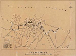
This picture shows the new seawall in 1859. The land behind it was later filled in. Today, Customs Street follows this seawall line.
|
|
| Location | Auckland Region, New Zealand |
| Coordinates | 36°50′45″S 174°46′06″E / 36.8457°S 174.7684°E |
| Ocean/sea sources | Waitematā Harbour |
Commercial Bay (Māori: Onepanea) was once a bay on the southern side of the Waitematā Harbour. It marked the original edge of the Auckland waterfront in Auckland, New Zealand. Today, the name Commercial Bay refers to a busy area. This area is full of buildings around lower Queen Street and Viaduct Harbour.
The old bay was located between two large pieces of land that stuck out into the water, called headlands. Smale's Point was on the west, separating Commercial Bay from Freemans Bay. Point Britomart was on the east, separating it from Official Bay and Mechanics Bay. The Waihorotiu Stream flowed down a valley into the bay. Commercial Bay got its name because it was planned to be the main business area for the new city. This was different from Official Bay, where government workers first lived.
Queen Street was built along the valley, next to the Waihorotiu Stream. Eventually, the stream was covered over. The headlands on both sides of the bay were dug up and removed between 1860 and 1920. Auckland used their stone to create new land by filling in parts of the seashore. This helped the city grow and build a new waterfront with many large docks, called quays. Now, the area where the bay and headlands once were is mostly covered with tall buildings.
Contents
What Was Commercial Bay?
Commercial Bay was a significant part of early Auckland. It was a natural bay that shaped the city's first coastline. The bay was a central point for the new settlement. It played a key role in how Auckland developed.
Early Days: Auckland's First Settlers
In 1840, a man named Logan Campbell set up his tent in Commercial Bay. He had heard that Auckland would become the capital city of the new colony of New Zealand. This meant it would be the main city where the government was located.
In 1853, a person named William Swainson described Auckland from the harbour. He said the city was built on the northern side of a narrow strip of land. This strip separated the Waitematā Harbour from the Manukau Harbour. He noted that most houses were built near the water. They were in the bays and on the headlands. Small valleys ran inland from these bays.
Building the Modern Waterfront
By 1859, a new wall, called a seawall, was built. It stretched from Fort Street to the new Customs Street East. This seawall created a boundary for the first 9 acres (36,000 square metres) of new land. This new land was made by filling in the curved coastline.
Creating New Land: Reclamation Efforts
Around this time, Smale's Point was being dug up. Its stone was used as fill to create more land. This also made it easier to get to Freemans Bay. In the 1870s and 1880s, Point Britomart was also quarried. Its material helped fill in Mechanics Bay.
By 1955, about 1.6 square kilometres of land had been filled in. Commercial Bay no longer looked like a natural bay. It had become a completely changed part of Auckland's landscape.
 | Victor J. Glover |
 | Yvonne Cagle |
 | Jeanette Epps |
 | Bernard A. Harris Jr. |


