
Concepción, Paraguay facts for kids
Quick facts for kids
Concepción
|
|||
|---|---|---|---|
|
City and district
|
|||
 |
|||
|
|||

Concepción, Paraguay
Location in Paraguay
|
|||
| Country | Paraguay | ||
| Department | Concepción | ||
| Area | |||
| • Total | 8,490 km2 (3,280 sq mi) | ||
| Elevation | 44 m (144 ft) | ||
| Population
(2008)
|
|||
| • Total | 76,378 | ||
| • Density | 8.996/km2 (23.300/sq mi) | ||
| Time zone | UTC-04 (AST) | ||
| • Summer (DST) | UTC-03 (ADT) | ||
| Area code(s) | 8700 | ||
| Climate | Aw | ||

.PNG)
Concepción is a city in northern Paraguay. It is the capital of the Concepción Department. The city is located right next to the Paraguay River.
A Spanish Governor named Agustín Fernando de Pinedo founded Concepción in 1773. In the early 1900s, the city grew a lot. It became an important center for the northern part of Paraguay. This was because it helped transport goods from the Gran Chaco region. Concepción also became a busy river port. The city played a role during a period of change in Paraguay's history in 1947. Today, it is an important religious center for the Roman Catholic Diocese of Concepción en Paraguay.
Getting Around Concepción
Concepción is connected to other cities by roads. Route 5 is a main road called "Gral. Bernardino Caballero." It links Concepción to cities like Pedro Juan Caballero and Asunción, the capital of Paraguay.
Concepción's Climate
Concepción has a tropical savanna climate. This means it has a wet season and a dry season. Summers are very hot and rainy. They can also be quite humid. During summer, strong thunderstorms are common. These storms can bring a lot of rain quickly. They can also have strong winds and sometimes even hail.
Winter in Concepción is much drier and cooler. It often feels like a drought during this time. The city is very close to the Tropic of Capricorn. This imaginary line is just south of Concepción.
| Climate data for Concepción (1991–2020, extremes 1937–present) | |||||||||||||
|---|---|---|---|---|---|---|---|---|---|---|---|---|---|
| Month | Jan | Feb | Mar | Apr | May | Jun | Jul | Aug | Sep | Oct | Nov | Dec | Year |
| Record high °C (°F) | 43.0 (109.4) |
41.0 (105.8) |
41.6 (106.9) |
38.2 (100.8) |
36.5 (97.7) |
36.4 (97.5) |
36.2 (97.2) |
40.0 (104.0) |
42.4 (108.3) |
43.0 (109.4) |
43.5 (110.3) |
41.4 (106.5) |
43.5 (110.3) |
| Mean daily maximum °C (°F) | 34.6 (94.3) |
33.7 (92.7) |
33.0 (91.4) |
30.7 (87.3) |
26.6 (79.9) |
25.6 (78.1) |
25.6 (78.1) |
28.5 (83.3) |
30.5 (86.9) |
32.1 (89.8) |
32.4 (90.3) |
33.7 (92.7) |
30.6 (87.1) |
| Daily mean °C (°F) | 28.0 (82.4) |
27.2 (81.0) |
26.3 (79.3) |
23.9 (75.0) |
20.2 (68.4) |
19.2 (66.6) |
18.4 (65.1) |
20.4 (68.7) |
22.7 (72.9) |
25.3 (77.5) |
25.8 (78.4) |
27.4 (81.3) |
23.7 (74.7) |
| Mean daily minimum °C (°F) | 23.3 (73.9) |
22.8 (73.0) |
21.7 (71.1) |
19.2 (66.6) |
15.7 (60.3) |
14.7 (58.5) |
13.2 (55.8) |
14.5 (58.1) |
17.0 (62.6) |
20.3 (68.5) |
20.7 (69.3) |
22.6 (72.7) |
18.8 (65.8) |
| Record low °C (°F) | 12.5 (54.5) |
12.0 (53.6) |
8.0 (46.4) |
5.3 (41.5) |
1.5 (34.7) |
0.0 (32.0) |
−1.5 (29.3) |
−2.8 (27.0) |
1.8 (35.2) |
5.7 (42.3) |
9.5 (49.1) |
11.4 (52.5) |
−2.8 (27.0) |
| Average precipitation mm (inches) | 158.9 (6.26) |
152.9 (6.02) |
129.6 (5.10) |
142.2 (5.60) |
113.7 (4.48) |
68.6 (2.70) |
37.7 (1.48) |
28.9 (1.14) |
76.3 (3.00) |
138.2 (5.44) |
200.0 (7.87) |
163.0 (6.42) |
1,409.8 (55.50) |
| Average precipitation days (≥ 0.1 mm) | 10 | 9 | 8 | 7 | 7 | 7 | 5 | 6 | 7 | 8 | 8 | 10 | 92 |
| Average relative humidity (%) | 69 | 73 | 74 | 76 | 77 | 77 | 72 | 70 | 68 | 67 | 67 | 70 | 72 |
| Mean monthly sunshine hours | 224 | 213 | 217 | 184 | 182 | 152 | 183 | 156 | 173 | 208 | 222 | 222 | 2,336 |
| Source 1: NOAA (July, November, and December record highs, and March, April and October record lows) (precipitation days, humidity 1961-1990), Meteo Climat (record highs and lows) | |||||||||||||
| Source 2: Deutscher Wetterdienst (sun) Ogimet | |||||||||||||
Images for kids
-
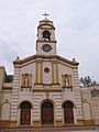
Main Catholic chapel in Concepción

See also
 In Spanish: Concepción (Paraguay) para niños
