
Congress, Arizona facts for kids
Quick facts for kids
Congress, Arizona
|
|
|---|---|

View of Congress and the mine, c.1914.
|
|

Location in Yavapai County and the state of Arizona
|
|

Congress, Arizona
Location in the United States
|
|
| Country | United States |
| State | Arizona |
| County | Yavapai |
| Area | |
| • Total | 37.77 sq mi (97.83 km2) |
| • Land | 37.74 sq mi (97.74 km2) |
| • Water | 0.04 sq mi (0.09 km2) |
| Elevation | 3,045 ft (928 m) |
| Population
(2020)
|
|
| • Total | 1,811 |
| • Density | 47.99/sq mi (18.53/km2) |
| Time zone | UTC-7 (MST) |
| ZIP code |
85332
|
| Area code(s) | 928 |
| FIPS code | 04-15220 |
| GNIS feature ID | 0003172 |
Congress (also called Old Congress) is a small community in Yavapai County, Arizona, United States. It's known as a census-designated place (CDP). This means it's a place the government counts for population, but it's not officially a city or town.
Congress was once a busy place for gold mining. It was home to the famous Congress Mine. After the mines closed, it became a ghost town. Today, Congress is a quiet place where many people retire. It also serves as a bedroom community for people who work in nearby Wickenburg. In 2020, about 1,811 people lived there.
Contents
History of Congress
Gold Mining Days
Gold was first found at the Congress Mine in 1884. This discovery brought many people to the area. By 1893, a train track, the Santa Fe, Prescott and Phoenix Railway, was built nearby. It passed within three miles of the mine at a spot called Congress Junction.
The town of Congress grew quickly because of the mine. It stayed successful for many years. The mines produced a lot of gold, worth millions of dollars. They finally closed down in the mid-1930s.
From Mining Town to Modern Community
After the mines closed, the original mining town became very quiet. The post office moved to Congress Junction in 1938. This new location is what we now call Congress. Not much is left of the very first mining camp. However, the old Congress Cemetery is still there.
Geography and Climate
Where is Congress Located?
Congress is located in Arizona at these coordinates: 34°8′46″N 112°50′48″W / 34.14611°N 112.84667°W. It covers an area of about 37.7 square miles (97.7 square kilometers). Most of this area is land, with only a tiny bit of water.
What is the Climate Like?
The climate in Congress is described as semi-arid. This means it's usually dry, but not a complete desert. It gets some rain, but not a lot.
Population and People
| Historical population | |||
|---|---|---|---|
| Census | Pop. | %± | |
| 2020 | 1,811 | — | |
| U.S. Decennial Census | |||
In 2020, the population of Congress was 1,811 people. There were 801 households living in the area. The population density was about 47.9 people per square mile. This means it's not a very crowded place.
Many people living in Congress are older adults. About 37.6% of the population was 65 years old or older in 2020. Only about 13.3% of the people were under 18 years old.
Education in Congress
Students in Congress attend local schools. The Congress Elementary School District runs a school for younger students. This school teaches children from kindergarten up to 8th grade.
After 8th grade, students go to high school in a different town. They attend Wickenburg High School. This school is part of the Wickenburg Unified School District. Before 2001, all students from Congress went to Wickenburg for all their schooling.
Gallery
-
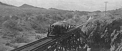
Porter locomotive #873, used near Congress in the early 1900s.
-
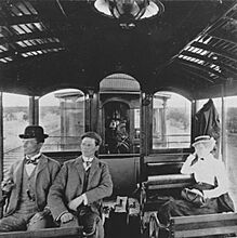
People from Congress on a trip to Phoenix, c. 1905.


See also
 In Spanish: Congress (Arizona) para niños
