Congress Heights facts for kids
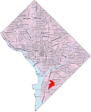
Congress Heights is a neighborhood located in Southeast Washington, D.C.. It's mostly a place where people live, with homes and families. The neighborhood has an interesting shape and is surrounded by several streets and landmarks. These include the St. Elizabeths Hospital campus, Shepard Parkway, and Oxon Run Parkway. You'll find many shops and businesses along Martin Luther King, Jr. Avenue and Malcolm X Avenue.
Contents
Exploring the History of Congress Heights
How the Area Looked Before Development
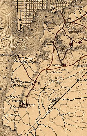
Before Congress Heights became a neighborhood, it was mostly covered by forests and farms. The land was undeveloped, with open water where some areas are now. The main way to get to this area was by the Navy Yard Bridge, built in 1820.
The first homes built east of the Anacostia River were in a place called Uniontown in 1854. Today, this area is known as Anacostia. A year later, the government built a hospital called the Government Hospital for the Insane. It's now known as St. Elizabeths Hospital. To reach the hospital, a road called Asylum Avenue was built. This road is now Martin Luther King, Jr. Avenue.
During the American Civil War (1861-1865), more buildings appeared. The U.S. Department of War built a cavalry supply building on Giesborough Point. Two forts, Fort Carroll and Fort Greble, were also built on nearby hills. After the war, in 1867, the Barry Farm housing area was created for people who had been freed from slavery. It quickly filled up with residents. Asylum Avenue was later renamed Nichols Avenue in 1879.
The Founding of Congress Heights
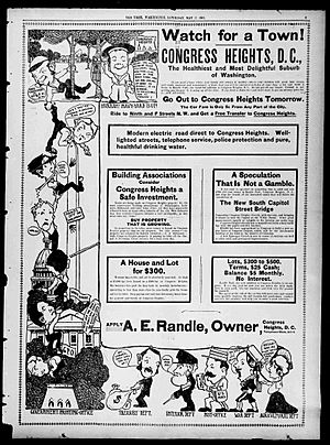
Congress Heights officially started in 1890. A successful newspaper publisher named Colonel Arthur E. Randle decided to create a new community east of the Anacostia River. He named it Congress Heights. A new bridge, the Pennsylvania Avenue Bridge (now the John Philip Sousa Bridge), was almost finished. Randle knew this bridge would bring lots of growth to the area, and he wanted to be part of it.
His new development was very popular right away. To help it grow even more, Randle invested in local streetcar companies. He started the Capital Railway Company in 1895 to build streetcar lines that would connect Congress Heights to other parts of the city. These streetcars made it much easier for people to travel to and from the new neighborhood. Randle later sold his share in the railway and used the money to develop other successful neighborhoods nearby, like Randle Highlands.
Because Congress Heights and the areas along Nichols Avenue grew so quickly, the city decided to extend South Capitol Street into the area. This new road helped connect Congress Heights even better to the rest of Washington, D.C.
Congress Heights in the 20th Century
From the 1930s to the 1950s, Congress Heights was mainly a neighborhood for white working-class families. Many of these families had moved from southern states like Virginia and North Carolina. They often worked at places like the Navy Yard or Bolling Air Force Base.
Congress Heights was home to the very last working farm in Washington, D.C. George Lindner had grown vegetables on his family farm for over 50 years before it closed in 1939.
Before World War II, the D.C. National Guard had a facility called Camp Simms in the area. It had firing ranges and was used for training. During World War II, anti-aircraft guns were placed there to protect Washington, D.C., from air attacks. After the war, the U.S. Army built a military reserve facility in Congress Heights. Many early residents also worked at the U.S. Naval Gun Factory or the United States Naval Research Laboratory.
After World War II, Congress Heights faced some challenges, including urban neglect. However, in the 21st century, the neighborhood has seen a lot of new attention and development. Many projects, including new buildings and shopping areas, have been completed or are underway. For example, the St. Elizabeths West Campus is being redeveloped for federal use. There are also plans to improve the area around the Congress Heights Metro station and redevelop Camp Simms with new stores and homes.
The neighborhood is served by the Congress Heights station, which is on the Green Line of the Washington Metro subway system. Most people live in apartment buildings, but there are also older single-family homes. Students in the neighborhood attend Frank W. Ballou High School and Hart Middle School.
Destination Congress Heights is a local program that works to improve the neighborhood's businesses and community. It helps organize efforts to promote local shops and make the area a better place for everyone.
 | Madam C. J. Walker |
 | Janet Emerson Bashen |
 | Annie Turnbo Malone |
 | Maggie L. Walker |


