Connecticut River Walk Park facts for kids

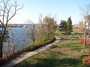
The Connecticut River Walk is a special park and bikeway in Springfield, Massachusetts. It runs along the banks of the Connecticut River, which is the biggest river in New England. This park is still being built, but parts of it are already open for people to enjoy.
The section of the park in Springfield is about 3.7 miles long. It stretches from Chicopee, Massachusetts to the South End Bridge in Springfield. What makes this trail unique is that it runs right next to an active train line, which is why it's called a "rail-with-trail." It also passes very close to the famous Naismith Memorial Basketball Hall of Fame.
The Connecticut River is a very important natural feature for the area. For hundreds of years, it has been a source of local pride. However, a big highway called Interstate 91 was built in the 1960s. This highway is elevated, meaning it's built high above the ground. It has made it hard for people in Springfield to get to the river and enjoy it, which has slowed down the city's growth near the river.
Contents
What's Being Added to the Park?
The Connecticut River Walk and Bikeway is still growing! The first two parts of the park are already open for everyone to use.
Current Open Sections
The part of the park in Springfield is about 3.7 miles long. Another section in Agawam, Massachusetts, is about 1.7 miles long.
Future Plans for the Walkway
When it's all finished, the entire route is planned to be about 20 miles long. It will run through land owned by the city, which is a floodplain (an area of low land next to a river that might flood).
Getting to the River Walk
Since the 1960s, the Interstate 91 highway has made it difficult for people in Springfield to reach the Connecticut River. This highway has blocked off the riverfront, making it hard to develop new businesses or fun activities there.
How Interstate 91 Blocks the River
The Connecticut River Walk & Bikeway was created to bring the riverfront back to life. The goal is to make it a central part of the community again. Interstate 91 and the things built around it, like parking lots underneath the highway, tall grassy mounds, and even 20-foot-tall stone walls, create big barriers. These barriers make it hard for people to walk from downtown Springfield (called Metro Center) to the Connecticut River Walk.
Park Entrances and Activities
The 3.7-mile park in Springfield has three main ways to enter. One of these is a 60-foot-tall footbridge located behind the LA Fitness gym, which is part of the Basketball Hall of Fame complex. To encourage people to use the park, the city of Springfield used to hold "lunchtime walks" on Wednesdays at 12:15 pm in 2011.
In 2010, a group from Boston called the Urban Land Institute suggested ideas for connecting Springfield with its riverfront again. However, as of 2011, Interstate 91 still acts as a physical wall between Springfield, the Connecticut River, and the Basketball Hall of Fame.
 | Roy Wilkins |
 | John Lewis |
 | Linda Carol Brown |

