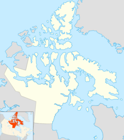
Contwoyto Lake facts for kids
Quick facts for kids Contwoyto Lake |
|
|---|---|
| Location | Kitikmeot Region, Nunavut |
| Coordinates | 65°40′N 110°40′W / 65.667°N 110.667°W |
| Primary outflows | Burnside River |
| Basin countries | Canada |
| Surface area | 957 km2 (369 sq mi) |
| Shore length1 | 982 km (610 mi) |
| Surface elevation | 564 m (1,850 ft) |
| Settlements | uninhabited |
| 1 Shore length is not a well-defined measure. | |
Contwoyto Lake is a large lake in Nunavut, Canada. It is found in the Kitikmeot Region. The lake is very close to the border with the Northwest Territories.
Contwoyto Lake covers about 957 square kilometers. This makes it the tenth largest lake in all of Nunavut.
A place called Lupin Mine is located near the lake. Contwoyto Lake is also the end of a special road. This road is called the Tibbitt to Contwoyto Winter Road. It starts at Tibbitt Lake in the Northwest Territories. This winter road is the only road that connects Nunavut to the rest of Canada.
In 2005, people discussed making this winter road even longer. They thought about extending it to a place called Bathurst Inlet. A port might be built there in the future.
What is the Climate Like at Contwoyto Lake?
The area around Contwoyto Lake has a very cold climate. It is known as a subarctic climate. This means winters are long and very cold. Summers are short and cool.
The average temperature for the whole year is around -11.8 degrees Celsius. January is usually the coldest month. The average temperature in January is about -31.4 degrees Celsius. July is the warmest month. Its average temperature is around 9.9 degrees Celsius.
The lake area gets about 246.6 millimeters of precipitation each year. Most of this comes as snow. Snowfall is common from September to May. Rain usually falls during the short summer months.
 | DeHart Hubbard |
 | Wilma Rudolph |
 | Jesse Owens |
 | Jackie Joyner-Kersee |
 | Major Taylor |


