Coodanup, Western Australia facts for kids
Quick facts for kids CoodanupMandurah, Western Australia |
|||||||||||||||
|---|---|---|---|---|---|---|---|---|---|---|---|---|---|---|---|

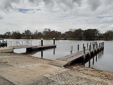
Jetties near the mouth of the Serpentine River at Coodanup
|
|||||||||||||||
| Established | 1956 | ||||||||||||||
| Postcode(s) | 6210 | ||||||||||||||
| Area | [convert: needs a number] | ||||||||||||||
| LGA(s) | City of Mandurah | ||||||||||||||
| State electorate(s) | Mandurah | ||||||||||||||
| Federal Division(s) | Canning | ||||||||||||||
|
|||||||||||||||
Coodanup is a suburb located in the south-east part of Mandurah, Western Australia. It's part of the City of Mandurah, which is its local government area.
Contents
Discovering Coodanup's Past
The name "Coodanup" has a bit of a mystery! We don't know exactly where it came from. However, back in 1836, a person named Lieutenant Henry Bunbury wrote something interesting. He noted that the local Noongar people called the mouth of the Serpentine River "Colanup." This suggests the name might have come from the area's original Indigenous inhabitants.
Where is Coodanup Located?
Coodanup is surrounded by some cool natural features and roads. To the east, you'll find the Serpentine River. The large Harvey Estuary is to the south. Pinjarra Road forms the northern border. To the west, Coodanup is bordered by the Mandurah Bypass and Wanjeep Street.
Getting Around Coodanup
Public transport helps people travel through Coodanup and to other places.
Bus Services in Coodanup
- Route 597: This bus goes from Coodanup to Mandurah Station. It travels along Peel Parade, Beacham Street, Broun Road, Wanjeep Street, Coodanup Drive, Steerforth Drive, and Pinjarra Road.
- Routes 600 and 605: These buses connect Mandurah Station to Pinjarra. They both use Pinjarra Road.
- Route 604: This bus runs from Mandurah Station to the South Yunderup Boat Ramp. It also uses Pinjarra Road.
 | Sharif Bey |
 | Hale Woodruff |
 | Richmond Barthé |
 | Purvis Young |

