Greenfields, Western Australia facts for kids
Quick facts for kids GreenfieldsMandurah, Western Australia |
|||||||||||||||
|---|---|---|---|---|---|---|---|---|---|---|---|---|---|---|---|

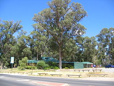
Community centre at Greenfields, Mandurah, Western Australia
|
|||||||||||||||
| Postcode(s) | 6210 | ||||||||||||||
| Area | [convert: needs a number] | ||||||||||||||
| LGA(s) | City of Mandurah | ||||||||||||||
| State electorate(s) | Mandurah | ||||||||||||||
| Federal Division(s) | Canning | ||||||||||||||
|
|||||||||||||||
Greenfields is a suburb located just east of Mandurah, a city in Western Australia. It's known for being a peaceful area with places for older people to live and a big oval for sports and fun activities.
The name Greenfields came from "Greenfields Estate," which was how developers promoted the area back in 1980 when it was being planned. Before that, it was also known by other names like Goegrup and Riverside Gardens.
Getting Around Greenfields
Getting around Greenfields and to nearby places is easy thanks to the local bus services. These buses connect Greenfields to important locations like the Mandurah and Lakelands train stations, and other suburbs.
Bus Routes
Several bus routes serve Greenfields, helping people travel to different parts of the area and beyond:
- Route 586 travels between Mandurah Station and Lakelands Station. It passes through key roads in Greenfields, including Murdoch Drive and Bortolo Drive, and serves John Tonkin College.
- Route 598 connects Mandurah Station directly to Greenfields. This route covers many streets within the suburb, such as Waldron Boulevard, Minilya Parkway, and Old Pinjarra Road.
Buses on Pinjarra Road
Pinjarra Road is a main road that runs through or near Greenfields. Several bus routes use this road to connect to other areas:
- Route 597 goes from Mandurah Station to Coodanup.
- Routes 600 and 605 travel from Mandurah Station to Pinjarra.
- Route 604 connects Mandurah Station to the South Yunderup Boat Ramp.
These bus services make it convenient for residents, including students, to get to school, shops, and other activities in Greenfields and the wider Mandurah area.
 | Georgia Louise Harris Brown |
 | Julian Abele |
 | Norma Merrick Sklarek |
 | William Sidney Pittman |

