Barragup, Western Australia facts for kids
Quick facts for kids BarragupMandurah, Western Australia |
|||||||||||||||
|---|---|---|---|---|---|---|---|---|---|---|---|---|---|---|---|

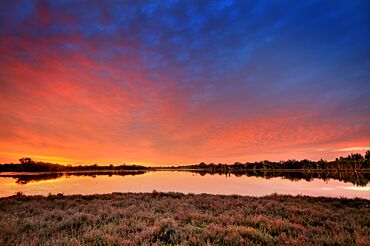
Sunset over Black Lake, Barragup
|
|||||||||||||||
| Postcode(s) | 6209 | ||||||||||||||
| Area | [convert: needs a number] | ||||||||||||||
| Location | 7.5 km (5 mi) from Mandurah | ||||||||||||||
| LGA(s) | Shire of Murray | ||||||||||||||
| State electorate(s) | Murray-Wellington | ||||||||||||||
| Federal Division(s) | Canning | ||||||||||||||
|
|||||||||||||||
Barragup is a small area or "locality" located in Western Australia. It is found near the city of Mandurah. Barragup is north of Pinjarra Road and east of the Serpentine River. It is part of the Shire of Murray.
The postcode for Barragup is 6209. In 2016, a count of the population showed that 806 people lived there. Barragup is mostly a rural area, meaning it has a lot of open land and farms. There are also some small businesses along Pinjarra Road.
For a while, only one bus route, the Transperth 598, served Barragup. This bus traveled along Pinjarra Road. But in October 2012, two more bus services were added. These new buses, routes 600 and 604, helped people travel further east along Pinjarra Road.
Getting Around Barragup
Bus Services
Buses are an important way to travel in Barragup. Here are the main bus routes that serve the area:
- Route 600 and 605: These buses travel from Mandurah Station to Pinjarra. They use Pinjarra Road to get through Barragup.
- Route 604: This bus goes from Mandurah Station to the South Yunderup Boat Ramp. It also uses Pinjarra Road in Barragup.
 | Victor J. Glover |
 | Yvonne Cagle |
 | Jeanette Epps |
 | Bernard A. Harris Jr. |

