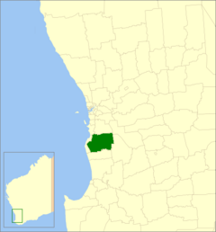
Shire of Murray facts for kids
Quick facts for kids Shire of MurrayWestern Australia |
|||||||||||||||
|---|---|---|---|---|---|---|---|---|---|---|---|---|---|---|---|

Location in Western Australia
|
|||||||||||||||
| Established | 1868 | ||||||||||||||
| Area | 1,710.1 km2 (660.3 sq mi) | ||||||||||||||
| Shire President | David Bolt | ||||||||||||||
| Council seat | Pinjarra | ||||||||||||||
| Region | Peel region Greater Mandurah |
||||||||||||||
| State electorate(s) | Murray-Wellington | ||||||||||||||
| Federal Division(s) | Canning | ||||||||||||||
 |
|||||||||||||||
| Website | Shire of Murray | ||||||||||||||
|
|||||||||||||||
The Shire of Murray is a local government area in Western Australia. It's like a local council that manages a specific region. This area covers about 1,710 square kilometers. It is located in the Peel Region, about 80 kilometers south of Perth.
The Shire stretches from the Peel Inlet and the flat Swan Coastal Plain up to the Darling Scarp hills. It includes about 77,000 hectares of State forests. In the past, people mostly worked in timber logging and farming. Today, mining for bauxite (a rock used to make aluminum) is important. The area also has a big horse industry and lots of tourism.
The Murray River flows through the Shire all year round. The main town in the Shire is Pinjarra. It is one of the oldest towns in Western Australia. You can still see many old mud brick buildings from the 1800s there. The Shire offers horse racing, a golf course, and many fun festivals.
Contents
History of the Shire of Murray
The first European settlement in this area began in 1834. Sir Thomas Peel was one of the first settlers. On November 7, 1868, the Murray District Roads Committee held its very first meeting in Pinjarra. This committee was in charge of local roads.
The Shire of Murray officially started as the Murray Road District on January 25, 1871. Later, on July 1, 1961, it changed its name to the Shire of Murray. This happened because of a new law called the Local Government Act 1960. This law changed all road districts into shires.
Towns and Localities in the Shire
The Shire of Murray is made up of several towns and smaller areas called localities. Here is a list of them with their populations based on the most recent Australian census:
| Suburb | Population | Area | Map |
|---|---|---|---|
| Banksiadale | 0 (SAL 2016) | [convert: needs a number] | |
| Barragup | 940 (SAL 2021) | [convert: needs a number] | |
| Birchmont | 86 (SAL 2021) | [convert: needs a number] | |
| Blythewood | 85 (SAL 2021) | [convert: needs a number] | |
| Coolup | 420 (SAL 2021) | [convert: needs a number] | |
| Dwellingup | 524 (SAL 2021) | [convert: needs a number] | |
| Etmilyn | 0 (SAL 2016) | [convert: needs a number] | |
| Fairbridge | 55 (SAL 2021) | [convert: needs a number] | |
| Furnissdale | 1,061 (SAL 2021) | [convert: needs a number] | |
| Holyoake | 22 (SAL 2021) | [convert: needs a number] | |
| Inglehope | 18 (SAL 2021) | [convert: needs a number] | |
| Keralup * | 0 (SAL 2021) | [convert: needs a number] | |
| Marrinup | 4 (SAL 2016) | [convert: needs a number] | |
| Meelon | 174 (SAL 2021) | [convert: needs a number] | |
| Myara | 0 (SAL 2016) | [convert: needs a number] | |
| Nambeelup | 361 (SAL 2021) | [convert: needs a number] | |
| Nirimba | 80 (SAL 2021) | [convert: needs a number] | |
| North Dandalup | 863 (SAL 2021) | [convert: needs a number] | |
| North Yunderup | 840 (SAL 2021) | [convert: needs a number] | |
| Oakley | [convert: needs a number] | ||
| Pinjarra | 4,914 (SAL 2021) | [convert: needs a number] | |
| Point Grey | [convert: needs a number] | ||
| Ravenswood | 2,483 (SAL 2021) | [convert: needs a number] | |
| Solus | 0 (SAL 2016) | [convert: needs a number] | |
| South Yunderup | 3,860 (SAL 2021) | [convert: needs a number] | |
| Stake Hill | 469 (SAL 2021) | [convert: needs a number] | |
| Teesdale | 89 (SAL 2021) | [convert: needs a number] | |
| West Coolup | 182 (SAL 2021) | [convert: needs a number] | |
| West Pinjarra | 448 (SAL 2021) | [convert: needs a number] | |
| Whittaker | 9 (SAL 2021) | [convert: needs a number] |
- For the 2021 Australian census, Oakley was counted as part of Fairbridge.
- For the 2021 Australian census, Point Grey was counted as part of Nirimba.
How the Population Has Grown
The number of people living in the Shire of Murray has changed over time. Here's a look at the population from 1911 to 2021:
| Historical population | |||||||||||||||||||||||||||||||||||||||||||||||||||||||||||||
|---|---|---|---|---|---|---|---|---|---|---|---|---|---|---|---|---|---|---|---|---|---|---|---|---|---|---|---|---|---|---|---|---|---|---|---|---|---|---|---|---|---|---|---|---|---|---|---|---|---|---|---|---|---|---|---|---|---|---|---|---|---|
|
|
||||||||||||||||||||||||||||||||||||||||||||||||||||||||||||
- In 1954, the town of Mandurah, which used to be part of Murray, became its own area. At that time, Mandurah had 1,687 people.
Places with Special Heritage
The Shire of Murray has many places that are important for their history. As of 2023, there are 134 such places. Out of these, 13 are so important that they are listed on the State Register of Heritage Places. This means they are officially protected because of their historical value.
 | Percy Lavon Julian |
 | Katherine Johnson |
 | George Washington Carver |
 | Annie Easley |

