Shire of Serpentine-Jarrahdale facts for kids
Quick facts for kids Shire of Serpentine-JarrahdaleWestern Australia |
|||||||||||||||
|---|---|---|---|---|---|---|---|---|---|---|---|---|---|---|---|

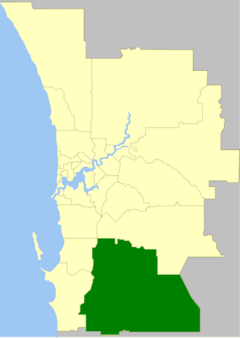
The Shire of Serpentine-Jarrahdale within the Perth Metropolitan Area
|
|||||||||||||||
| Established | 1894 | ||||||||||||||
| Area | 905 km2 (349.4 sq mi) | ||||||||||||||
| Shire President | Rob Coales | ||||||||||||||
| Council seat | Mundijong | ||||||||||||||
| Region | Peel region | ||||||||||||||
| State electorate(s) | Darling Range | ||||||||||||||
| Federal Division(s) | Canning | ||||||||||||||
 |
|||||||||||||||
| Website | Shire of Serpentine-Jarrahdale | ||||||||||||||
|
|||||||||||||||
The Shire of Serpentine-Jarrahdale is a local government area located in the outer southeastern part of Perth, the capital city of Western Australia. It covers an area of about 905 square kilometers (350 square miles). In 2021, its population was 32,173 people. Even though the Shire is named after the towns of Serpentine and Jarrahdale, the largest town is actually Byford. The main office for the Shire government is in Mundijong.
Contents
A Look Back at Serpentine-Jarrahdale's History
The area we now know as the Shire of Serpentine-Jarrahdale was first formed on 8 August 1913. It was created by joining two older areas: the Serpentine Road District (from 1894) and the Jarrahdale Road District (from 1902). A "Road District" was an early type of local government in Australia, mainly in charge of roads.
On 1 July 1961, the area officially became a "Shire." This change happened because of a new law called the Local Government Act 1960. This law turned all remaining road districts into shires. Later, on 17 June 1977, the Shire of Serpentine-Jarrahdale grew bigger when it added the town of Byford from the Shire of Armadale–Kelmscott.
Understanding the Population
The most recent count of people, called the 2021 census, showed that the Shire had 32,173 residents. About 2.9% of these residents were Indigenous people. The average age of people living in the Shire was 33 years old. This is younger than the average age for all of Australia and Western Australia, which is 38.
How the Shire is Governed
The Shire of Serpentine-Jarrahdale is managed by a group of elected people called the Council. They make decisions for the local community.
Council Members and Elections
The most recent election for the Shire Council happened on 21 October 2023. In this election, Rob Coales, who was already a councillor for the North Ward, was chosen as the new Shire President. He won with 2,182 votes. The Shire President is like the leader of the local government.
Here are the current members of the Council:
| President | Role |
|---|---|
| Rob Coales | Elected as Shire President in 2023. |
| Councillor | Role |
| Tricia Duggin | Represents the South Ward. She has been the Deputy President since 2023. |
| Reece Jerrett | Represents the South Ward. |
| Shaye Mack | Represents the North Ward. She was elected in 2022. |
| Rob Coales | Also represents the North Ward, in addition to being Shire President. |
| Morgan Byas | Represents the North West Ward. He was first elected in 2017. |
| Nathan Bishop | Represents the North West Ward. |
Shire Wards and Their Purpose
The Shire is divided into different areas called "wards." Each ward has a certain number of councillors who represent the people living in that area. This helps make sure that all parts of the Shire have a voice in the Council.
The Shire used to have four wards: Byford, Central, North West, and South. However, on 29 July 2011, the boundaries of these wards were changed. The new wards are:
- North (which has 4 councillors)
- North West (which has 2 councillors)
- Southern (which has 3 councillors)
Elections were held on 15 October 2011 to choose the councillors for these new wards.
Towns and Communities
The Shire of Serpentine-Jarrahdale is made up of several suburbs, towns, and smaller communities. The table below shows their populations and sizes based on the latest census.
| Suburb | Population | Area | Map |
|---|---|---|---|
| Byford | 18,878 (2021) | [convert: needs a number] | |
| Cardup | 1,163 (2021) | [convert: needs a number] | |
| Darling Downs | 1,591 (2021) | [convert: needs a number] | |
| Hopeland | 313 (2021) | [convert: needs a number] | |
| Jarrahdale | 1,205 (2021) | [convert: needs a number] | |
| Karrakup | 172 (2021) | [convert: needs a number] | |
| Keysbrook | 265 (2021) | [convert: needs a number] | |
| Mardella | 446 (2021) | [convert: needs a number] | |
| Mundijong | 1,246 (2021) | [convert: needs a number] | |
| Oakford | 2,803 (2021) | [convert: needs a number] | |
| Oldbury | 296 (2021) | [convert: needs a number] | |
| Serpentine | 2,863 (2021) | [convert: needs a number] | |
| Whitby | 1,005 (2021) | [convert: needs a number] |
How the Population Has Grown
The population of the Shire of Serpentine-Jarrahdale has changed a lot over the years. Here's a look at how many people have lived there at different times:
| Historical population | |||||||||||||||||||||||||||||||||||||||||||||||||||||||||||||
|---|---|---|---|---|---|---|---|---|---|---|---|---|---|---|---|---|---|---|---|---|---|---|---|---|---|---|---|---|---|---|---|---|---|---|---|---|---|---|---|---|---|---|---|---|---|---|---|---|---|---|---|---|---|---|---|---|---|---|---|---|---|
|
|
||||||||||||||||||||||||||||||||||||||||||||||||||||||||||||
- In 1911, the Serpentine Road District had 328 people, and the Jarrahdale Road District had 1,126 people.
- The big jump in population in 1976 happened after the town of Byford and nearby areas, with 1,634 residents, became part of the Shire in 1977.
Special Heritage Places
As of 2024, there are 112 places in the Shire of Serpentine-Jarrahdale that are recognized for their special history or importance. These are called "heritage-listed" places. Five of these places are so important that they are listed on the State Register of Heritage Places. This means they are officially protected because of their historical value.
 | Jessica Watkins |
 | Robert Henry Lawrence Jr. |
 | Mae Jemison |
 | Sian Proctor |
 | Guion Bluford |

