
Serpentine, Western Australia facts for kids
Quick facts for kids SerpentineWestern Australia |
|||||||||||||||
|---|---|---|---|---|---|---|---|---|---|---|---|---|---|---|---|

Serpentine in 2009
|
|||||||||||||||
| Established | 1893 | ||||||||||||||
| Postcode(s) | 6125 | ||||||||||||||
| Area | 104.8 km2 (40.5 sq mi) | ||||||||||||||
| Location | 55 km (34 mi) from Perth | ||||||||||||||
| LGA(s) | Shire of Serpentine-Jarrahdale | ||||||||||||||
| State electorate(s) | Darling Range | ||||||||||||||
| Federal Division(s) | Canning | ||||||||||||||
|
|||||||||||||||
Serpentine is a town in Western Australia. It's about 55 kilometers (34 miles) south-east of Perth, the capital city. The town is also 7 kilometers south of Mundijong.
Serpentine is located on the South Western Railway. This railway connects Perth and Bunbury. Serpentine was one of the first stations when the line opened in 1893. In 2016, about 1,265 people lived in Serpentine.
The BOM weather radar for Perth is now located near Serpentine. The Bodhinyana Buddhist Monastery is also close to the town. Serpentine is a stop for the Australind passenger train. This train travels between Perth and Bunbury.
Contents
Discovering Serpentine's Past
Early European Settlement
The town of Serpentine gets its name from the nearby Serpentine River. The river was named in the 1830s because it has many twists and turns, like a snake. European settlers started a community south of the river in the 1830s.
More settlers arrived from 1849 onwards. They came as part of government plans to buy farmland. In 1856, a cemetery was set up for the area. It had separate sections for Catholics and Protestants. About 645 people are buried there. Mathew Hale, who was the first Anglican Bishop of Western Australia, often lived in a cottage he built in Serpentine around 1864.
During the 1880s, Serpentine was an important stop for Cobb & Co stagecoaches. These were like horse-drawn buses that carried people and mail.
In 1891, the government opened up land for farming in the area. They called it the Serpentine Agricultural Area. By 1893, there was enough demand for land. So, the Townsite of Serpentine was officially created in December 1893. However, a new railway station opened further west in 1893. This made the old town center less important.

Serpentine in the 20th Century
Before World War I ended in 1918, Serpentine mostly had small farms. These farms raised different animals like cattle, sheep, and pigs.
In the early 1920s, the Western Australian government started the Group Settlement Scheme. Under this plan, about 150 farms were built in Serpentine and Hopeland. Each farm was about 45 hectares (111 acres) in size. Most of these were dairy farms, producing milk. By 2018, only four dairy farms were still operating in Serpentine. The 1920s also saw new businesses open. These included two general stores, a butcher shop, a tearoom, and a garage.
During the Great Depression, a cheese factory was built. It was opened by Premier James Mitchell on August 8, 1932. At that time, it was the only working cheese factory in Western Australia. It operated until 1951. Today, it is a heritage-listed place.
The Second World War affected local life. People faced rationing and shortages of workers and supplies. In the summer of 1940-1941, the Serpentine River stopped flowing for the first time since 1914. But in the winter of 1945, Serpentine experienced floods. The Serpentine River flooded most of the farmlands north of it. The region also had many rabbits. This problem lasted until the Myxoma virus was introduced in 1951.
Places to See and Explore
Churches and Monasteries

Saint Stephen's Church in Serpentine is an Anglican church. It is part of the Diocese of Perth. The church's foundation stone was laid on May 10, 1913. The church was officially opened on December 6, 1913. Plans for a stone church in Serpentine had existed since 1885.
The Bodhinyana monastery is located on the edge of Serpentine. It was started in 1983 by Buddhist monks from the Thai forest tradition. They were invited by the Buddhist Society of Western Australia. Next to the monastery is the Jhana Grove Meditation Centre. This center was opened in October 2009.
Learning in Serpentine

Serpentine's first school was built in 1859. It was called the Serpentine Bridge School. The school buildings became old and worn out. So, a new school room and teacher's house were built in 1889. In 1954, the Bridge School closed. A new primary school opened in the town center to replace it. Most of the old school's buildings were moved or taken down.
The current primary school is called Serpentine Primary School. It was established in 1954. In 2024, about 184 students attend the school.
Gallery
-
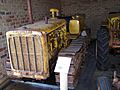
Caterpillar D2 on display in the Serpentine Vintage Tractor Museum
-
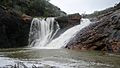
Nearby Serpentine Falls


