Mundijong, Western Australia facts for kids
Quick facts for kids MundijongPerth, Western Australia |
|||||||||||||||
|---|---|---|---|---|---|---|---|---|---|---|---|---|---|---|---|

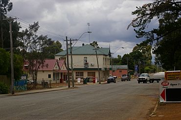
Paterson Street, Mundijong
|
|||||||||||||||
| Established | 1890s | ||||||||||||||
| Postcode(s) | 6123 | ||||||||||||||
| Area | 18.4 km2 (7.1 sq mi) | ||||||||||||||
| Location | |||||||||||||||
| LGA(s) | Shire of Serpentine-Jarrahdale | ||||||||||||||
| State electorate(s) | Darling Range | ||||||||||||||
| Federal Division(s) | Canning | ||||||||||||||
|
|||||||||||||||
Mundijong is a suburb located just outside Perth, the capital city of Western Australia. It was first settled in the 1890s.
This area was originally called Jarrahdale Junction. This was because it was where two important railway lines met. One line was the Jarrahdale to Rockingham railway line. The other was the main government railway line from Perth to Bunbury, built in 1893.
In 2016, a census counted 1,232 people living in Mundijong.
History of Mundijong's Name
A town started to grow around the railway junction. A large timber depot was built there, which included a special mill to smooth wood.
The town was first named "Manjedal" in 1893. People thought this was the correct Aboriginal name for the area. However, in 1897, it was discovered that this name was incorrect. So, the name was officially changed to Mundijong. It became an official locality on May 1, 1997.
Getting Around Mundijong
Mundijong has bus services that help people travel to nearby towns and cities.
Bus Services
Buses connect Mundijong to Armadale Station, which is a major transport hub.
- Bus route 252 travels from Mundijong to Armadale Station. It uses Paterson Street and Soldiers Road.
- Bus route 253 travels from Jarrahdale to Armadale Station. It also passes through Mundijong on Watkins Road, Paterson Street, and Soldiers Road.
 | Jackie Robinson |
 | Jack Johnson |
 | Althea Gibson |
 | Arthur Ashe |
 | Muhammad Ali |

