Cardup, Western Australia facts for kids
Quick facts for kids CardupPerth, Western Australia |
|||||||||||||||
|---|---|---|---|---|---|---|---|---|---|---|---|---|---|---|---|

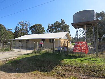
Baker Hall in Cardup in August 2022
|
|||||||||||||||
| Established | 1927 | ||||||||||||||
| Postcode(s) | 6123 | ||||||||||||||
| Area | [convert: needs a number] | ||||||||||||||
| Location | |||||||||||||||
| LGA(s) | Shire of Serpentine-Jarrahdale | ||||||||||||||
| State electorate(s) | Darling Range | ||||||||||||||
| Federal Division(s) | Canning | ||||||||||||||
|
|||||||||||||||
Cardup is a small suburb located outside of Perth, the capital city of Western Australia. It is part of the Shire of Serpentine-Jarrahdale, found just north of the town of Mundijong. In 2011, about 972 people lived in Cardup.
Contents
Discovering Cardup's Past
Cardup has a long and interesting history. In 1844, a surveyor named Robert Austin first wrote down the name "Cardoup" for this area. There was also a brook, or small stream, nearby that was called Cardoup or Cadup Brook.
Later, in 1851, a person named H. Mead bought land here. He used "Cardup" as his address. This spelling then became common for the brook on maps and surveys.
How Cardup Got Its Name
By 1927, a special railway stop, called a "siding," was built close by. It was named Cardup after the brook. Even though this railway siding is not used anymore, the area still keeps the name. The name Cardup comes from an Aboriginal word. It is believed to mean "place of the racehorse goanna" (Kurda).
Getting Around Cardup
Even though Cardup is a smaller suburb, there are ways to get around.
Bus Services in Cardup
Local buses help people travel to and from Cardup.
- Bus route 252 travels from Mundijong to Armadale Station. This bus serves Soldiers Road in Cardup.
- Bus route 253 goes from Jarrahdale to Armadale Station. This route also serves Soldiers Road.
 | John T. Biggers |
 | Thomas Blackshear |
 | Mark Bradford |
 | Beverly Buchanan |

