Byford, Western Australia facts for kids
Quick facts for kids ByfordPerth, Western Australia |
|||||||||||||||
|---|---|---|---|---|---|---|---|---|---|---|---|---|---|---|---|

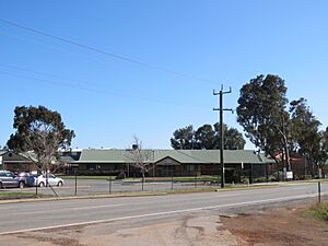
George Street, Byford, in August 2022
|
|||||||||||||||
| Postcode(s) | 6122 | ||||||||||||||
| Area | 22 km2 (8.5 sq mi) | ||||||||||||||
| Location | |||||||||||||||
| LGA(s) | Shire of Serpentine-Jarrahdale | ||||||||||||||
| State electorate(s) | Darling Range | ||||||||||||||
| Federal Division(s) | Canning | ||||||||||||||
|
|||||||||||||||
Byford is a suburb located on the south-eastern edge of Perth, Western Australia. It is part of the Shire of Serpentine-Jarrahdale. The town started as a small settlement called "Beenup" in 1906. Later, in 1920, its name was officially changed to Byford.
Contents
What's in a Name? The Story of Byford
Byford's first name was 'Beenup'. This name came from an Aboriginal name linked to a nearby stream called Beenyup Brook. The original spelling, "Bienyup," was even mentioned by a surveyor named Robert Austin in 1848.
On April 23, 1920, the town's name was changed to Byford. Residents voted on the new name, choosing Byford over other options like Beenup, Beenyup, Glengeorge, and Winterbourne. In 2020, the Byford Progress Association celebrated 100 years since the town was named.
Byford's Past: A Look at Its History
Early Days and Brickmaking
Not much is known about the Aboriginal people who lived in the Byford area long ago. However, signs of their presence have been found in many places.
During the early days of the colony, European settlers began to claim land around the 1840s. These small farms were set up near Wungong and Cardup. By the 1890s, a few large landowners, like the Lazenby, Mead, and Liddelow families, lived in the area. Early settlers often faced tough conditions before they could build proper houses.
Making bricks was a big part of Byford's growth. People knew about the clay (shale) at Cardup as early as the 1850s. But it wasn't until the early 1900s that a company started making bricks there. In 1903, John Millard started The Cardup Steam Pressed Brick Company. This company grew to be one of the state's top brick producers.
Another large brick factory opened in Beenup (north of Cardup) in 1913. This factory was started by the government to help lower the cost of housing for workers. Like the Cardup factory, it used the local clay to make high-quality bricks. These bricks were then sent to customers by train. The State Brickworks in Byford closed in 1964. The Cardup brickworks closed in 2012, but many of its old buildings are still there.
After the brickworks opened, a local landowner, Mr. C. C. Blythe, planned a new town on the east side of the railway line. This new town, which is now the main part of Byford, has a unique design with circles and diagonal roads. Blythe also built a hall for the new settlement. Residents chose a new name for the town in 1919, and it became official the next year. Early community buildings included Anglican and Presbyterian churches and a state school.
The original 1906 town was located south-west of Soldiers Road and Mead Street. However, not many houses were built there until much later. The 1906 town did include land for recreation, which is still used today.
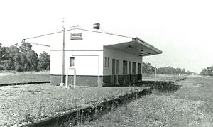
The South Western Railway reached the area in 1892. It was used to transport timber, and later, eggs and milk from Byford to Perth. A stop called Beenup was set up near the current town. In 1957, a station was built between Abernethy Road and Mead Street. This station was taken down around 1990 after being unused for a long time. The current Byford station is just south of this spot. It is served by the Australind train service, which runs twice daily from Perth to Bunbury.
In the 1920s, a local landowner's property was divided into smaller farms for the Group Settlement Scheme. This scheme brought 40 families to Byford to start dairy farms. However, most families left because the soil was poor and the water levels were too high.
Secret Armament Depot
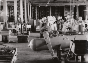
During World War II, after the Fall of Singapore, a secret weapons depot was built in Byford in 1942. It was chosen because it had train access and was far enough from the coast to be safe from attacks by the Japanese. In December 1942, explosives from Britain began to be stored there. The depot later grew to hold mines and gun equipment.
Throughout the war, it supplied weapons to Allied navies, except for the Americans. When British submarines started operating in Fremantle in 1944, this depot was where their ammunition was put together. At its busiest, about 250 civilian workers were employed there. The depot's existence was made public at the end of the war.
Security for the depot was handled by the Naval Dockyard Police (NDP). They were the last part of the Royal Australian Army to use horses for patrols. Byford was one of only two depots in Australia patrolled by the NDP. The NDP patrolled the Byford depot until 1952. The depot was known as "R.A.N. 145" during the war, and later as "Naval Armament Depot, Byford."
In 1981, the depot in Byford moved to Garden Island. In 2005, the remaining buildings were taken down to make way for a new housing area called "Byford on the Scarp."
Byford Today: Growth and Development
In 1977, the local government responsibilities for Byford moved from the City of Armadale to the Shire of Serpentine-Jarrahdale. Recently, Byford has grown to become part of the Perth metropolitan area. It is now connected to the Kwinana Freeway by Thomas Road, and its population has increased a lot.
Historically, Byford's land was used for sheep, cattle, orchards, and even a vineyard. But in recent years, more people have started "hobby farms" for horses. There are also many new housing estates with large blocks of land.
A Free Reformed Church opened in Byford in 1987. A private school was later built next to this church.
In the early 2010s, a new housing development called "The Glades" was built in the western part of town. It was the first development in Western Australia to receive special environmental certification. The Glades won several awards for its design. The name "The Glades" comes from the wide green spaces in the area. Different parts of the estate are named after local features or historical figures.
In 2017, a company started building the Byford Solar Farm. This will be the first large-scale solar farm in an Australian city area, and the biggest in Western Australia. Once finished, it will produce a lot of clean energy for the region. The project is expected to cost $140 million.
Places to See: Culture and Nature in Byford
Cohunu Koala Park, opened in 1982, is a wildlife sanctuary. It is home to many animals, including dingoes, koalas, kangaroos, wallabies, emus, deer, and owls. Byford also has many other parks and public sports fields.
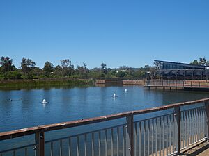
Lake Allambee is a human-made lake in The Glades. Its name comes from an Aboriginal language in Victoria and means "to sit" or "to remain a while." In 2018, a project was started to remove unwanted fish species from the lake.
Byford has several important cultural sites. There is a war memorial honoring those who fought in World War I and II, as well as the Korean, Malaysian, Borneo, and Vietnam Wars. A larger war memorial for the ANZACs opened on April 18, 2015. This memorial remembers 321 soldiers from Byford who died.
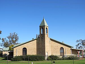
Religious sites in Byford include the Saint Aidan Anglican church, the Free Reformed Church of Byford, Byford Baptist Church, and Centrepoint Church.
The Byford Trotting Training Complex, originally a dairy farm, was set up in 1969. This complex, used for horse racing training, was saved from being developed into housing in the late 1990s.
Byford's Sculptures: Art and History
Byford features nine sculptures created by Zen Luks. These sculptures show different parts of Byford's history and culture. They are located along the 7-kilometer (4.3-mile) Byford Sculpture trail on the South Western Highway.
Near the northern entrance, you'll find the Byford sign. Then there are sculptures of a girl with a cow, representing the early dairy industry. A tractor shows Byford's farming in the 1930s, and a trotter driver represents the horse racing complex. Other sculptures include Charlie Knox, a traffic inspector from the 1940s and 50s, and Sister Wossley, who nursed children. There's also a returned serviceman, a famous racehorse named Rivorse, two boxing kangaroos, a brickworker, a cockatoo, and a kangaroo at the southern entrance.
Learning in Byford: Schools and Library
As Byford grows quickly, more schools are being built.
Children in the area have had access to education since 1908. Estelle Nairn, Byford's first full-time teacher, taught about 8 children at her parents' farm. This lasted for three years until she passed away. Two more schools operated in the 1910s before Byford Primary School (BPS) was founded in 1921. It is the oldest school in the area. In 2015, it became an independent school. An early childhood building was added in 2018. The school also teaches Italian.
Marri Grove Primary School opened in 1993 because Byford Primary was getting too crowded. It is a government school with an Indonesian program. Byford John Calvin School, a private school, opened on January 29, 1999, next to the Free Reformed Church. West Byford Primary, another government school, opened in February 2013 in Byford's west.
Salvado Catholic College, a Catholic school for students from Kindergarten to Year 12, opened in 2016. It is named after Dom Rosendo Salvado, and its motto is “Peace, Justice, Compassion.” This school also teaches Italian. Woodland Grove Primary School, a government school, opened in 2017. The newest school is Beenyup Primary School, which opened in 2020.
Byford Secondary College is the only high school in Byford and the Shire of Serpentine-Jarrahdale. It is a government school that opened in 2014.
The Byford Community Kindergarten was built in 1978. In 2017, it was considered at high risk for bushfires due to nearby bushland. It reopened in 2019.
Byford Library
On March 29, 2021, the Serpentine-Jarrahdale council decided to move the shire's library services from Mundijong to Byford Hall. The Shire President, Michelle Rich, explained that the Mundijong library was too small for future growth. A new library in Byford would be closer to most of the area's population. The project cost $2.65 million.
Getting Around: Transport in Byford
Roads
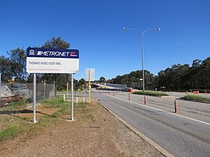
Byford is where the South Western Highway and Thomas Road meet. Thomas Road ends here. As part of the Metronet Byford Rail Extension Project, the section of Thomas Road before the intersection was raised. This was done to remove the old train crossing. The new Thomas Road bridge opened on November 15, 2022.
Here are the two main roads that go through Byford:
 South Western Highway (State Route 20) – goes south to Pinjarra and Bunbury.
 Thomas Road (State Route 21) – goes west to Kwinana; ends in Byford.
Other important roads include Abernethy Road, which connects Oakford to the South Western Highway. Nettleton Road connects Byford to Jarrahdale through Karrakup. Soldiers Road connects to Mundijong.
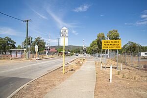
On December 18, 2023, the Larsen Road rail crossing was permanently closed as part of Metronet. This crossing was a key way to cross the railway in Byford, located near Marri Grove. The closure caused concern among the public, who worried about increased traffic on Abernathy and Thomas roads. To help with school traffic, a temporary drop-off area was created near Marri Grove in January 2024. A temporary pedestrian bridge will also be used until a permanent one is built in April 2024.
Public Transport
As part of the Metronet Byford Rail Extension Project, the Armadale train line will be extended 8 kilometers (5 miles) south to a new station in Byford. The Armadale Line was temporarily closed on November 20, 2023, for this work. The new station will be across from George Street and will have three platforms for passengers on the Australind and Armadale lines. State Minister of Transport, Rita Saffioti, and local Member of Parliament, Hugh Jones, said the new station would help Byford grow in the future.
Bus Services
- 251 Byford to Armadale Station – serves Clondyke Drive, Benalla Crescent, Wilaring Street and South Western Highway
- 252 Mundijong to Armadale Station – serves Clondyke Drive, Benalla Crescent, Wilaring Street and South Western Highway
- 253 Jarrahdale to Armadale Station – serves Clondyke Drive, Benalla Crescent, Wilaring Street and South Western Highway
- 254 Byford to Armadale Station – serves Clifton Street, Abernethy Road, Gordin Way, Mead Street, Doley Road, Gallipoli Avenue, Tourmaline Boulevard, Kardan Boulevard, Ballawarra Avenue, Malarkey Road, Eurythmic Road, Larsen Road, Plaistowe Boulevard, Thomas Road and South Western Highway
 | Sharif Bey |
 | Hale Woodruff |
 | Richmond Barthé |
 | Purvis Young |


