
Wungong, Western Australia facts for kids
Quick facts for kids WungongPerth, Western Australia |
|||||||||||||||
|---|---|---|---|---|---|---|---|---|---|---|---|---|---|---|---|

View over Wongong Farm, from the railway, prior to subdivision. (1994)
|
|||||||||||||||
| Postcode(s) | 6112 | ||||||||||||||
| Area | 4.3 km2 (1.7 sq mi) | ||||||||||||||
| Location | |||||||||||||||
| LGA(s) | City of Armadale | ||||||||||||||
| State electorate(s) | Armadale | ||||||||||||||
| Federal Division(s) | Burt Canning |
||||||||||||||
|
|||||||||||||||
Wungong (sometimes spelled Wongong) is a suburb located south-east of Perth, Western Australia. It's a mix of rural and suburban areas, found between the towns of Armadale and Byford. Wungong is part of the City of Armadale local government area. The name "Wungong" comes from the Nyungar language and means "embracing." This refers to how the two branches of Wungong Brook wrap around the land where the first farm was built.
Contents
History of Wungong
Early Days and Naming
The first official survey of this area happened in January 1835. An explorer named Alfred Hillman explored the stream here. He tried to name it the 'Marshall River', but that name didn't stick.
The name "Wungong" first appeared on a map in 1844. It showed the 'Woongan River' and a farm called 'Wongong' farm. The name is Aboriginal and means "embracing." This describes how the north and south parts of Wungong Brook surround the land.
Over time, the spelling changed. For many years, the farm and the railway stop were called 'Wongong'. In 1909, the government started using 'Wungong' (with a 'u') for a new townsite. This new spelling became more common after 1949, especially for the railway stop and a road. Some people think the 'u' was added to avoid confusion with Wongan Hills.
Growing Community
Before 1900, only a few farms and properties were in the Wungong area. The South Western Railway was built through Wungong in 1892. A railway stop was created, which helped local children get to school in Armadale and allowed milk to be transported. The stop was moved in 1910 to a better location and was used until 1969.
Around the 1890s, a large area of land was divided into smaller lots. This brought many new settlers, including people from the United Kingdom. A plan for a townsite called 'Wungong Townsite' was made in 1909, but it was never fully developed.
The community grew, and families like Cockshott, Hilbert, and Marsh settled here. They built a community hall in 1913, which became the main gathering place for about 50 years. It was used for religious services, meetings, elections, and even as a classroom. The hall was later moved in 1963, but the original site is still important to many local residents.
Wungong Dam and Water Supply
In the 1890s, some settlers also lived in the hills along the Wongong Brook. One important farmer was Walter Butcher. His farm was located upstream from where the Wungong Dam is now.
The Wungong Dam is a very important part of Perth's water supply. Before the main dam, a smaller pipehead dam was built in 1925. This supplied a lot of water to the Perth metropolitan area. Plans for a larger dam were made then, but construction didn't start until 1975. The Wungong Dam was finished in 1979. It can hold a huge amount of water and helps provide drinking water for Perth. Water from the dam travels through a large steel pipe and also through the Wungong Tunnel, which runs underground.
Wungong Today
In the early 1900s, there were places near the railway where gravel was dug up. Some of these old digging sites can still be seen. One large area was later used as a swimming hole by local kids and then as a rubbish dump. Today, this area is a fenced-off nature reserve called Lambert Lane Nature Reserve.
Fun Things to See and Do
Fletcher Park
.jpg)
Fletcher Park is a large bushland area on the east side of the railway. It covers about 19 hectares (47 acres). The Cooliabbera Creek runs through it. The park has tall marri trees and many grass trees. You can also find the Western Australian Christmas tree here. Part of the park is leased to the Wallangara Riding and Pony Club, which has riding areas and facilities.
Wongong Brook

Wongong Brook has always been a popular spot for fun and relaxation. In the early days of cars, it was a well-known place for picnics. Many postcards were even made showing the beautiful brook. For generations, local children have enjoyed playing in the deeper parts of the brook. They have paddled, swum, and even caught marron and gilgies (small freshwater lobsters) in its waters.
Wongong Gorge and Parks
The Wongong Gorge and the hills behind Wungong are great for bushwalking. A lot of bushland is protected in these hills, especially in Bungendore Park. This park was first set aside for timber in 1897, but later became a parkland. Today, Bungendore Park is a large area of nearly 500 hectares (1,235 acres). It's an important part of the Darling Range Regional Park.
The Wongong Gorge is outside Bungendore Park, but it's part of the Wungong Regional Park, which was created in 2008. These parks are home to many different plants and animals. Scientists have found hundreds of plant species and over a hundred types of animals, including birds and mammals, in Bungendore Park alone.
Armadale Reptile and Wildlife Centre
.jpg)
The Armadale Reptile and Wildlife Centre is a private wildlife sanctuary in Wungong. It opened in 1995 and has the largest public display of reptiles and amphibians in Western Australia. You can also see other animals like dingoes, flying foxes, farm animals, marsupials, and birds there.
Places of Interest in Wungong
- Wongong farm: This includes old buildings, early gardens, and signs of the first farm from 1844.
- South Western Highway: This was once an old road to Bunbury. You can still see parts of old bridges and a popular picnic spot on the Wongong Brook.
- Butcher farm, Upper Wongong: Remains of an old farm, including a waterwheel and parts of a government bridge.
- Wungong Dam and Tunnel: One of Perth's biggest water reservoirs, built in 1979. It's also the site of an earlier dam and important engineering structures.
- Bungendore Park and Wongong Gorge: Beautiful bushland that has been protected since 1908. You can find signs of old gold mining and quarrying here.
- Cooliabbera: Stone ruins and old gardens from around 1870. This place has links to the famous artist May Gibbs.
- Railway reserve: This area includes the old Wongong station site, the railway line from 1892, Fletcher Park, and Lambert Lane Nature Reserve. It has important bushland and signs of old gravel digging.
- Bodicoat's corner: The intersection of Wungong and Eleventh Roads, named after 'Granny Bodicoat', a local midwife who lived there.
- Wongong Congregational Mission Hall: The site of the old community hall that was a central meeting place from 1913 to 1963.
- Marsh's house: An old brick house from around 1890, which is the oldest home continuously lived in west of the railway.
- Wongong Brook west of Rowley Road: Parklands with deep sections of the brook that were mapped in the 1840s and were a popular swimming spot in the mid-1900s.
Wungong Today
Wungong has three main areas, each with a different feel:
- The hills: This area includes 'Upper Wungong', with bushland that has grown back and some semi-rural homes.
- The corridor: This is the area between the South Western Highway and the South Western Railway.
- The flats or plain: This area is west of the railway, with many hobby farms.
Historically, the flats west of the railway were mostly small farms. Some of these smaller farms still exist today. However, since the late 1980s, this area has been changing into new suburban neighborhoods that are part of the Perth metropolitan area. For example, the suburb of Brookdale has grown here.
New community facilities have also been built. The Evelyn Gribble Community Centre was built in the 1990s. Other long-standing businesses and facilities include the Rose Valley Cheese Company, the Australian Christian College - Darling Downs (which used to be the Seventh Day Adventist Church and School), and retirement villas.
Getting Around Wungong
Bus Services
- Route 249: Travels from Armadale Station to Hilbert. It serves Wungong Road, Eleventh Road, and Rowley Road.
- Routes 251 and 254: Go from Armadale Station to Byford. These buses use the South Western Highway.
- Route 252: Connects Armadale Station to Mundijong via the South Western Highway.
- Route 253: Runs from Armadale Station to Jarrahdale along the South Western Highway.
Images for kids
-
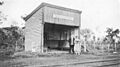
Wongong railway station, circa 1935 (State Library of Western Australia, B3524139_9)
-
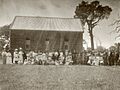
Opening of the Wongong hall, 1913 (Birtwistle Local Studies Library)
-
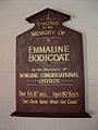
Memorial board for Emmaline 'Granny' Bodicoat, district midwife, which originally hung in the Wongong hall.
-
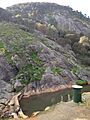
Weir in the Wongong Gorge. The area in the background is part of Bungendore Park. (2015)


.jpg)

