Mount Richon, Western Australia facts for kids
Quick facts for kids Mount RichonPerth, Western Australia |
|||||||||||||||
|---|---|---|---|---|---|---|---|---|---|---|---|---|---|---|---|

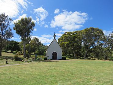
The Schoenstatt Shrine in Mount Richon
|
|||||||||||||||
| Postcode(s) | 6112 | ||||||||||||||
| Area | 1.6 km2 (0.6 sq mi) | ||||||||||||||
| Location | |||||||||||||||
| LGA(s) | City of Armadale | ||||||||||||||
| State electorate(s) | Armadale | ||||||||||||||
| Federal Division(s) | Canning | ||||||||||||||
|
|||||||||||||||
Mount Richon is a suburb located in Perth, Western Australia. It's part of the City of Armadale. This area became its own suburb in 2003. Before that, it was part of Armadale and Wungong. Mount Richon sits on the western side of the Darling Range. It's bordered by important roads like Albany Highway and South Western Highway. The suburb got its name from an old vineyard that used to be there.
Contents
Exploring Mount Richon's Past
Mount Richon has an interesting history. People have lived here for a very long time. Let's look at some key moments in its past.
Early Days and Mining
Long ago, Aboriginal people lived in this area. Later, European explorers arrived. In the late 1840s, the W.A. Mining Company started the colony's first mining project here. This was called Cole's Shaft.
Roads and Inns
Over time, major roads like Albany Highway and South Western Highway were built. The Narrogin Inn was also established. There's a local legend about "Dead Man's Gully." This gully is named after an incident where a horse rider was killed in the 1800s.
Local Industries and Vineyards
The Armadale Brickworks opened, using shale from the nearby hillside. They even had a special tramline to move materials. People also cut wood in the area, which helped create Bedfordale Hill Road.
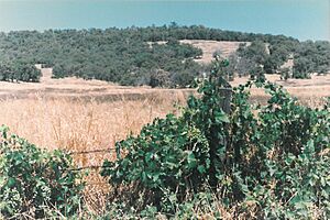
A vineyard called Marian's Vineyard was started. It was also known as the Slavonian Vineyard. Later, Gerald McCarthy renamed it Richon Vineyards. He had served in Rishon Le Zion during World War I. A granite quarry also operated here in the 1920s.
Changes and Growth
The Armadale Brickworks and shale quarry eventually closed. New houses started to appear on the hillside above Armadale. Bushfires from Bedfordale were sometimes a problem.
The Richon Vineyards closed in the 1950s. The vines were removed, and the old buildings fell into ruin.
More houses were built around Tredale Avenue after Armadale High School opened in 1957. Around 1990, the Schoenstatt Shrine was built. The caravan park was developed, and the old vineyard property was divided into new lots in the early 1990s.
Waterways of Mount Richon
Several streams flow through or near Mount Richon. These waterways are important to the local environment.
Neerigen Brook
The Neerigen Brook flows northwards along Albany Highway. It joins the Wungong Brook further north. Together, they form the Southern River, which flows into the Canning River. This brook usually flows only during certain seasons, but sometimes it flows all year.
Other Local Streams
An unnamed stream starts from springs on the hillside. It flows past the Schoenstatt Shrine and under the highway. This stream eventually joins the Wungong Brook.
Another seasonal stream forms a steep valley called 'Dead Man's Gully'. It flows under the South Western Highway. This stream eventually connects with the Wungong Brook.
A winter brook starts from springs on a hillside. It flows down a shallow valley. This stream is not visible west of the South Western Highway.
Cooliabbera Creek starts in Bungendore Park. It flows parallel to Leys Rise, just outside the suburb's southern edge. This creek joins the stream from Dead Man's Gully before flowing into the Wungong Brook.
Nature and Wildlife
Mount Richon has lots of natural beauty. Much of its eastern side is next to parkland with regrown bush. Some higher parts of the suburb still have native trees and plants.
Animals You Might See
Kangaroos often visit properties in Mount Richon. You might see them alone or in groups of up to twenty. They are attracted to the fresh green gardens. Smaller marsupials are also sometimes spotted.
The bushland here is home to many different lizards and snakes. Small freshwater crayfish, called gilgies, live in the Neerigen Brook. Many birds also live in the area. These include kookaburras, magpies, mudlarks, black crows, and various wrens. Over 80 different bird species have been seen in the nearby Bungendore Park.
Mount Richon Today
Mount Richon has different types of housing. The northern part of the suburb has houses mostly built from the 1960s to the 1980s. Some older homes, from the 1930s, are found along the South-Western Highway.
The old Armadale Brickworks shale quarry is a large area north of Bedfordale Hill Road. Across the road is Tredale Park. South of this area, you'll find larger, semi-rural properties. These houses were mostly built in the 1990s. The Schoenstatt Chapel is also in this section.
Further south is a caravan park called Hillside Garden Village. The southernmost part of Mount Richon was once the vineyard. This area now has suburban lots. The lots on higher ground are larger and have a semi-rural feel.
Getting Around Mount Richon
Public transport helps people get around Mount Richon.
Bus Services
- Bus routes 251 and 254 connect Armadale Station to Byford. These buses use South Western Highway.
- Bus route 252 goes from Armadale Station to Mundijong. It also uses South Western Highway.
- Bus route 253 travels from Armadale Station to Jarrahdale. This route also uses South Western Highway.
Understanding Local Names
Many street and place names in Mount Richon have interesting stories. They often come from early settlers, local features, or historical events.
- Aitken: A street named after an early resident of Wungong.
- Amethyst: A street name in the northern part of the suburb. It's one of eight streets named after precious stones, but these names don't have a local historical meaning.
- Beazley: A street named after important Western Australians, including a politician.
- Bedfordale: The name of the area just east of Mount Richon.
- Billings: A street named after an early family in Armadale.
- Burndale: The origin of this street name is not clear.
- Breakneck Gully: A steep valley crossed by South Western Highway. It's also known as Dead Man's Gully.
- Carrick: A street named after a young teacher who settled in the area around 1900.
- Cellar: A street in the old Richon Vineyards area, near where the vineyard's cellar building was.
- Chateau: A street name in the old Richon Vineyards area. A Chateau is a French manor house, hinting at wine estates.
- Claret: A street name in the old Richon Vineyards area, named after a type of red wine.
- Cooliabberra: A street named after an Aboriginal name for a nearby farming property.
- Crystal: Another street name in the northern part of the suburb, one of the eight named after precious stones.
- Dead Man's Gully: A steep valley crossed by South Western Highway. It's also known as Breakneck Gully.
- Emerald: Another street name in the northern part of the suburb, one of the eight named after precious stones.
- Garnet: Another street name in the northern part of the suburb, one of the eight named after precious stones.
- Harrison: A street named after an early family in Armadale.
- Hillside: A street named after a small farm developed by Joseph Serls and his wife Mary.
- Jade: Another street name in the northern part of the suburb, one of the eight named after precious stones.
- Leys: A road named after John Morgan Ley and Azelia Helena Ley, who owned property at the top of the hillside.
- Marian's Vineyard: The original name of the vineyard that the suburb is named after. It was also called the 'Slavonian vineyards'.
- Marsh: A street named after a family from Bedfordale and Armadale. Famous cricketer Rod Marsh is from this family.
- McCarthy's bald patch: A historical name for a large bare area on the hillside. It was named after GVP McCarthy, the vineyard owner, who was bald.
- Onyx: Another street name in the northern part of the suburb, one of the eight named after precious stones.
- Opal: Another street name in the northern part of the suburb, one of the eight named after precious stones.
- Richon: A street name in the old Richon Vineyards area. It refers to 'Rishon LeZion' in Israel, a place known by the vineyard's second owner.
- Rise: A street name that describes the street's elevated position.
- Sapphire: Another street name in the northern part of the suburb, one of the eight named after precious stones.
- Saw: A street named after Armadale's most important pioneering family.
- Summit: A street name that describes its location at the top of a hill.
- Talus: A street name meaning "ankle bone," which doesn't seem to have a local connection.
- Tredale: A street name linked to a rail stop used by Armadale High School students. For a time, part of Armadale was known as Tredale.
- Treecrest: A street name in the old Richon Vineyards area. It combines tree and crest, referring to the tree-covered hillside.
- Woodcroft: A street name in the old Richon Vineyards area. It combines wood and croft, but has no historical or geographical link to the area.
 | William M. Jackson |
 | Juan E. Gilbert |
 | Neil deGrasse Tyson |


