Keralup, Western Australia facts for kids
Quick facts for kids KeralupPerth, Western Australia |
|||||||||||||||
|---|---|---|---|---|---|---|---|---|---|---|---|---|---|---|---|

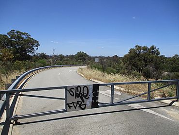
Barrier at the end of Paganoni Road blocking entry to the undeveloped estate
|
|||||||||||||||
| Established | 2007 | ||||||||||||||
| Postcode(s) | 6182 | ||||||||||||||
| Area | 40.3 km2 (15.6 sq mi) | ||||||||||||||
| Location | 58 km (36 mi) S of Perth | ||||||||||||||
| LGA(s) |
|
||||||||||||||
| State electorate(s) | Warnbro and Murray-Wellington | ||||||||||||||
| Federal Division(s) | Brand and Canning | ||||||||||||||
|
|||||||||||||||
Keralup is a special suburb located on the southern edge of Perth, Western Australia. It sits on the eastern side of the Kwinana Freeway. This entire area is owned by the government and is planned for future development.
The government has big plans for Keralup. It's expected to become home to about 90,000 people. Most of the new homes and buildings will be built on the eastern side of the Serpentine River.
What's in a Name? The Story of Keralup
The name "Keralup" was chosen in a unique way – through a newspaper poll! A respected local Nyoongar leader, Trevor Walley, suggested the name. He remembered a special pool in the Serpentine River where he and his friends used to play when they were kids. That pool was called Keralup.
Black History Month on Kiddle
Famous African-American Scientists:
 | Percy Lavon Julian |
 | Katherine Johnson |
 | George Washington Carver |
 | Annie Easley |

All content from Kiddle encyclopedia articles (including the article images and facts) can be freely used under Attribution-ShareAlike license, unless stated otherwise. Cite this article:
Keralup, Western Australia Facts for Kids. Kiddle Encyclopedia.
