Nambeelup, Western Australia facts for kids
Quick facts for kids NambeelupWestern Australia |
|||||||||||||||
|---|---|---|---|---|---|---|---|---|---|---|---|---|---|---|---|

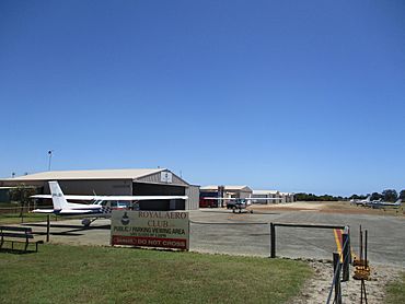
Murrayfield Airport in Nambeelup
|
|||||||||||||||
| Postcode(s) | 6207 | ||||||||||||||
| Area | [convert: needs a number] | ||||||||||||||
| Location | |||||||||||||||
| LGA(s) | Shire of Murray | ||||||||||||||
| State electorate(s) | Murray-Wellington | ||||||||||||||
| Federal Division(s) | Canning | ||||||||||||||
|
|||||||||||||||
Nambeelup is a small town in the Peel Region of Western Australia. It's also known as a "dormitory suburb" of the city of Mandurah. This means many people who live in Nambeelup travel to Mandurah for work, school, or other activities.
About Nambeelup
Nambeelup gets its name from a nearby waterway called Nambeelup Brook. Most of the land in Nambeelup is used for farming and rural activities. However, there are also some newer areas with homes and businesses. These areas are part of a development called St Davids.
Growing Community
Because the Peel Region is growing quickly, Nambeelup is expected to become an important industrial area for Mandurah. This means more businesses and job opportunities might come to the town in the future.
Murrayfield Airport
Nambeelup is home to Murrayfield Airport. This is a local airport that serves the Mandurah area. It's mainly used for smaller planes and doesn't offer flights for passengers. This is because Mandurah is quite close to Perth Airport, which handles all the big passenger flights.
Getting Around Nambeelup
Nambeelup is located near two major highways in Western Australia. These are the Kwinana Freeway and the South Western Highway. You can reach both highways using Lakes Road. Lakes Road also connects Nambeelup to Mandurah and North Dandalup. While there isn't a regular public bus service in Nambeelup, school buses do travel through the area for students.
 | Georgia Louise Harris Brown |
 | Julian Abele |
 | Norma Merrick Sklarek |
 | William Sidney Pittman |

