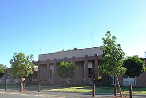
Murray Shire facts for kids
Quick facts for kids Murray ShireNew South Wales |
|||||||||||||||
|---|---|---|---|---|---|---|---|---|---|---|---|---|---|---|---|

Location of the former shire in New South Wales
|
|||||||||||||||
| Population | 7,312 (2012) | ||||||||||||||
| • Density | 1.5/km2 (3.9/sq mi) | ||||||||||||||
| Established | 1906 | ||||||||||||||
| Abolished | 12 May 2016 | ||||||||||||||
| Area | 4,345 km2 (1,677.6 sq mi) | ||||||||||||||
| Mayor | Cr. Thomas Weyrich (Independent) | ||||||||||||||
| Council seat | Mathoura | ||||||||||||||
| Region | Murray | ||||||||||||||
| State electorate(s) | Murray | ||||||||||||||
| Federal Division(s) | Farrer | ||||||||||||||
| Website | Murray Shire | ||||||||||||||
|
|||||||||||||||
Murray Shire was a local government area in the Murray region of south-western New South Wales, Australia. A local government area is like a local council that manages services for a specific region.
Murray Shire included the towns of Moama and Mathoura. It stopped existing on 12 May 2016. Its area then joined with the Wakool Shire to create a new council called the Murray River Council.
The last person to be the mayor of Murray Shire was Cr. Thomas Weyrich. A mayor is the leader of a local council. Cr. Weyrich was an independent politician, meaning he did not belong to a major political party.
History of the Murray Shire Area
The Murray Shire region began to develop in the 1840s. At that time, people called squatters settled on land to raise livestock. They followed the paths of overlanders, who moved cattle from Sydney to Adelaide in the late 1830s.
From the 1860s, selectors (people who chose and bought small plots of land) moved into the area. Many came from Victoria. They were mainly interested in farming. The towns of Moama and Mathoura grew as important places for farming goods and the timber industry.
The land that was once Murray Shire is very special. The Cadell Fault runs through the area from north to south. This fault line changed the path of the Murray River about 30,000 years ago. The Murray River system here is home to one of the biggest River Red Gum forests in the world.
Why Murray Shire Changed
In 2015, the NSW Government looked at how local government areas were set up. The Independent Pricing and Regulatory Tribunal suggested that Murray Shire should join with Wakool Shire. This would create a new, larger council.
The new council would cover about 11,865 square kilometres (4,581 sq mi). It would serve about 11,500 people. On 12 May 2016, the Minister for Local Government announced the change. Murray Shire and Wakool Shire officially ended. The new Murray River Council started right away. This change was made to help councils work more efficiently and provide better services.
How the Council Worked

Before it was dissolved, the Murray Shire Council had nine councillors. Councillors are elected representatives who make decisions for the local area. These councillors were chosen by a special voting system. They were all elected for a four-year term.
The mayor was chosen by the councillors themselves at their first meeting. The last election for the council was on 8 September 2012. All nine councillors were Independents or unaligned, meaning they did not belong to a political party.
The councillors who were elected in 2012 and served until 2016 included:
- Thomas Weyrich (Mayor)
- Bill Anderson
- Brian Sharp
- Betty Murphy
- Ian Moon
- Gavin Burke
- Gen Campbell
- John Pocklington (Deputy Mayor)
- Sue Mulcahy
 | Stephanie Wilson |
 | Charles Bolden |
 | Ronald McNair |
 | Frederick D. Gregory |

