Cadell Fault facts for kids
The Cadell Fault is a special crack in the Earth's crust in New South Wales and Victoria, Australia. It runs north-south, crossing the Murray River. This fault is famous because it has greatly changed the paths of several big rivers, including the Murray, Edward River, Wakool River, Goulburn River, and Campaspe River. Scientists say it's one of the best examples of how earthquakes can move rivers. You can even see part of the fault as a raised ridge along the Cobb Highway between Deniliquin and Echuca. The fault is likely named after Francis Cadell, an early explorer and trader on the Murray River.
Contents
Understanding the Cadell Fault's Geology
The landmass of Australia sits on a single large tectonic plate. This plate is mostly very stable. However, even stable plates can have cracks, called fault lines, deep within them. The Cadell Fault is one such fault line.
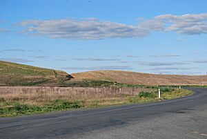
While these inner fault lines are usually quiet, they can sometimes cause big earthquakes. The Cadell Fault is an example of this. When the Cadell Fault moved, it pushed up the ground, creating a raised area called a scarp. This scarp looks like a continuous earthen ridge.
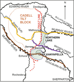
The northern part of this ridge stretches for 55 kilometres from Deniliquin to Echuca. It stands about 12 to 15 metres high. The southern part is about 13 kilometres long, south of Echuca, and is 3 to 4 metres high. A historic lake, Lake Kanyapella, helped create the gap between these two parts by eroding the land. The fault affects a thick layer of soft rock, about 200 to 250 metres deep, which sits on top of harder granite rock.
How the Cadell Fault Changed Rivers
The rising of the Cadell Fault had a huge effect on four major rivers in the Murray River system. It created what looks like an inland delta on the Murray River. This happened in the area between Barmah and Kyalite.
The Murray River's New Path
The uplift of the Cadell Fault greatly changed the Murray River's path. Before the fault moved, the Murray River flowed through a channel called Green Gully. This channel is now dry. It used to go west of Mathoura to join the current Murray River further west.
Green Gully was abandoned about 45,000 years ago because the fault uplifted. The fault started rising even earlier, about 65,000 years ago. But around 45,000 years ago, it rose enough to block the river's flow. This created a huge lake, which was fed by melting snow and ice from the Snowy Mountains.
After some time, the water found a new way to flow. It went north into what is now the Edward River. From there, it flowed west towards the Deniliquin area. An older stream, the Gulpa Creek, was formed by this northward flow. The main flow of the Murray might have also followed the path of the current Bullatale Creek during this time.
The large northern lake continued to exist. Evidence shows that sand and silt built up, forming long banks called silt jetties near present-day Barmah. Eventually, this lake drained, leaving behind wetlands and swamps. Today, Moira Lake and Barmah Lake are what's left of that big northern lake.
Recent studies suggest that the Murray River's current path through the Narrows, also known as the Barmah Choke, is quite new. It might have formed as recently as 550 years ago (around 1450 CE).
Local Aboriginal stories even say that the Aboriginal people helped create the Murray's current path. The legend tells that they carved a channel through a sandbank that was holding back the northern lake's water. This allowed the water to flow into the Goulburn River, forming the Murray's path we see today. Early settlers noticed that the Narrows had unusually straight sides, unlike the sloping banks of older rivers.
The blocking of the Murray River by the fault directly led to the creation of the Barmah Red Gum Forests. These forests are now protected in the Barmah National Park in Victoria and Murray Valley National Park in NSW. The fault's damming action caused river sediments to build up, forming the land where the red gum forests grew. The ongoing flooding and draining of this area created the unique forest ecosystem we see today.
The Edward River's Beginning
The Edward River largely exists because the Cadell Fault rose. While not studied as much as the Murray, water from the Northern Lake likely found an old tributary of the Murray. It then flowed across to meet the Wakool River and eventually the Murray at Kyalite.
Today, most of the Murray River's water flows north into the Edward River. A smaller amount continues south into the Murray itself.
The Goulburn River's Shift
Like the Murray, the Goulburn River used to flow north of its current path. It flowed through the Broken Creek and met the old Murray River (Green Gully) southwest of Mathoura. From there, it continued westward.
When the Cadell Fault rose, another large lake formed south of the Northern Lake. This was the original Lake Kanyapella. Strong winds blew soil, creating the Barmah Sandhills on the northeast edge of this lake. Over time, water from this lake flowed into the Campaspe River. The Goulburn River then changed its course to follow this new path. Water erosion eventually drained the prehistoric Lake Kanyapella along the path of the current Murray River.
The Campaspe River's Role
The path of the Campaspe River was not as directly changed by the Cadell Fault. However, the fault caused both the Goulburn and Murray rivers to flow through the ancient Campaspe's course. This meant that the Campaspe River upstream of Echuca became a branch of the new Murray. The parts of the Campaspe from Kaarimba to Kanyapella became part of the Goulburn River.
Managing Future Risks
The Cadell Fault is a place where big Earth movements have happened. Because many people live and work in this important region, Geoscience Australia has studied the chance of future earthquakes.
They have looked at what might happen in a very strong earthquake (called a maximum credible earthquake, about Mw 7.2). Their models suggest that such an earthquake would cause huge damage. Over 1,000 square kilometres of land could lose half of its buildings. A more common earthquake (about Mw 6.8) would cause less damage on its own. However, because it might happen more often, it could be a bigger risk over time. These are just estimates based on current information. Geoscience Australia has not said how sure they are about these predictions.
Future movements of the Cadell Fault could also change river courses again, just as they have in the past.
 | Sharif Bey |
 | Hale Woodruff |
 | Richmond Barthé |
 | Purvis Young |


