Murray River (Western Australia) facts for kids
Quick facts for kids Murray River |
|
|---|---|

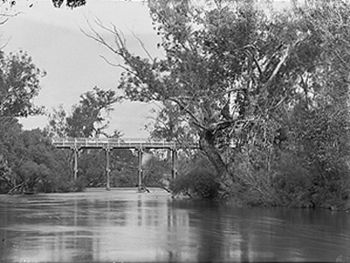
Pinjarra Bridge over the Murray River. ca 1900–1910
|
|
| Country | Australia |
| Physical characteristics | |
| Main source | Mount Keats 187 metres (614 ft) |
| River mouth | Peel-Harvey Estuary sea level |
| Length | 134 kilometres (83 mi) |
The Murray River is an important river in the southwest of Western Australia. It played a big part in the growth of settlements south of Perth. This happened after British settlers arrived at the Swan River Colony in 1829.
This river is special because it doesn't have dams built for public water supply. It collects water from a huge area. This area stretches from drier farmlands near Pingelly. It then goes through the wet Darling Range around Dwellingup.
Two main rivers flow into the Murray River. The Hotham River starts near Narrogin. The Williams River begins between Williams and Narrogin. These two rivers drain the eastern farming areas.
The Murray River then flows through forests in the Darling Range. It comes out near Pinjarra. Another river, the Dandalup River, joins the Murray a short way past Pinjarra. This part of the river is called the lower Murray. Small boats can travel on it.
The river then flows across a sandy plain. It goes between the Darling Scarp and the coast. Finally, it empties into the Peel Estuary near Mandurah. The canal areas of North and South Yunderup are a few kilometers upstream from the estuary.
Exploring the Murray River
The first European explorers came to this area in July 1829. A group led by Captain Currie saw a river in the distance. This river was later named the Serpentine River. It is north of the Murray River.
Later that year, in November, Dr Alexander Collie and Lieutenant William Preston explored the coast. They sailed into the Peel-Harvey Estuary. They met some local Aboriginal people there.
They then explored the Murray River delta. At that time, the river had five entrances into the estuary. Their boats went about 2 miles (3 km) up the river. They returned to Fremantle after a 12-day trip. This was their first real encounter with the Murray River.
Governor James Stirling named the river after Sir George Murray. He was an important government official in London. Soon after, settlers from the Swan River area began exploring the river. They chose land along its banks.
Thomas Peel's Settlement
Thomas Peel came to Australia with a promise of land. He was supposed to get a huge area if he brought 400 settlers. But he arrived late and with fewer settlers. So, Governor Stirling offered him different land. This land stretched from Woodman Point to the north bank of the Murray River. It also went from the ocean to the Darling Scarp.
Peel's settlers first lived at Clarence. Then they moved to what is now Mandurah. Peel named this place Peeltown. Despite many challenges, the settlement grew. By late 1830, a town called Pinjarra was established.
Pinjarra was about as far as boats could travel up the Murray River. It also had a natural crossing point for travelers. More land was given out along the river's south bank. However, growth was limited due to increasing conflicts with local Aboriginal people.
Conflict and Peace
These conflicts led to a serious event in October 1834. It is known as the Battle of Pinjarra. During this event, many Noongar people of the local Pindjarup group were killed by white settlers. This battle followed a raid in Perth by members of the Murray River tribe.
The next year, a formal agreement was made. This truce brought peace between the Murray River and Swan River Noongars and the white settlers. After this, peace was established. The towns around Pinjarra grew. The opening of the Perth to Bunbury railway in 1893 helped the area expand even more.
Dealing with Floods
Soon after farming started, settlers realized a problem. The land near the lower parts of the river often flooded every year. This was because the land was very flat between the Darling Scarp and the estuary. The problem got worse because many trees were cut down. These trees would have helped soak up extra water. Settlers described the area as a giant wetland. Travel was impossible for several months each year.
From 1900 until after the Second World War, a big effort was made to drain the flooded areas. Today, about one-third of all land in the Peel-Harvey area is close to a drain, stream, or river built by people.
 | Victor J. Glover |
 | Yvonne Cagle |
 | Jeanette Epps |
 | Bernard A. Harris Jr. |

