
Williams, Western Australia facts for kids
Quick facts for kids WilliamsWestern Australia |
|||||||||||||||
|---|---|---|---|---|---|---|---|---|---|---|---|---|---|---|---|

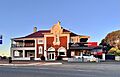
The Williams Hotel in 2022
|
|||||||||||||||

Williams
Location in Western Australia
|
|||||||||||||||
| Established | 1860s | ||||||||||||||
| Postcode(s) | 6391 | ||||||||||||||
| Area | [convert: needs a number] | ||||||||||||||
| Location | |||||||||||||||
| LGA(s) | Shire of Williams | ||||||||||||||
| State electorate(s) | Roe | ||||||||||||||
| Federal Division(s) | O'Connor | ||||||||||||||
|
|||||||||||||||

Williams is a small town in the Wheatbelt area of Western Australia. It is about 161 kilometres (100 miles) south-east of Perth, the state capital. The town is also about 32 kilometres (20 miles) west of Narrogin. The Williams River flows right through the town. In 2016, around 400 people lived in Williams.
Contents
A Look Back: Williams' History
How Williams Got Its Name
The town of Williams is named after the Williams River. This river was first seen by Captain Thomas Bannister in 1831. He was on an important trip from the Swan River Colony to King George Sound (which is now Albany). The river was put on a map in 1833. It is thought that the river, and later the town, were named after King William IV. He was the King of the United Kingdom from 1830 to 1837.
Early European Settlement
The first British claims on land in the Williams area happened in 1832. In 1835, Governor James Stirling and John Septimus Roe explored a path. This path connected King George Sound with York through Williams. They hoped this would encourage people to settle inland. However, not many people moved there at first.
Lieutenant Henry Bunbury explored the area in 1836. He thought the land near the Williams River was "generally very bad." He also noted that the water was "brackish," meaning it was a bit salty.
A Key Stop on the Albany Highway
In the 1850s, a major road called Albany Highway was built. This road was built by convicts. Williams then became a very important stop for travellers. It was a place where people could rest and change horses. This made Williams the main centre in the area.
The bridge over the Williams River was finished in 1855. The Williams Hotel, a place for travellers to stay, was built in 1871. A local group, the Road Board, started meeting in 1877. This group was like today's Shire Council.
In early 1898, about 55 people lived in the town. Later that year, a building called the Agricultural Hall was opened. It was built to help the local farming community.
Moving the Town
The original town of Williams was built on the Albany side of the river. But the land was being cleared for farming, which led to more floods. Because of this, the town was moved to the Perth side of the bridge. The new town site was planned out in 1905. Most of the buildings you see in Williams today were built after that time.
Williams was also a stop on the Brunswick Junction to Narrogin railway line. In 1959, the Williams District Club was built. The Williams Shire offices were also built in the same year.
Williams Today: A Farming Hub

Today, Williams is an important centre for farming. It is known for its wool, cattle, and grain industries. The town also continues to be a useful stopping point on Albany Highway.
Visitors can explore a heritage trail that shows off Williams' historic buildings. Nearby, you can find beautiful wildflower displays and dryandra forests. There is also a unique place called the Jesse Martin museum. This museum is a collection of old shops, post offices, and farm machinery. A local farmer built it on his own property.
Williams is a stop for Transwa bus services that go to Albany and Esperance. The town has three service stations, and one of them is open 24 hours a day.
Images for kids
-
The Williams Hotel in 2022
-
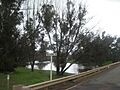
The Williams River flowing near the town
-
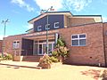
The Williams District Memorial Hall in 2018
