Cuballing, Western Australia facts for kids
Quick facts for kids CuballingWestern Australia |
|
|---|---|

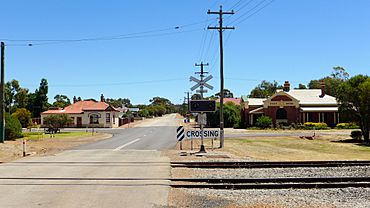
Cuballing West Road, 2014
|
|
| Established | 1889 |
| Postcode(s) | 6311 |
| Area | [convert: needs a number] |
| Location | |
| LGA(s) | Shire of Cuballing |
| State electorate(s) | Central Wheatbelt |
| Federal Division(s) | O'Connor |
Cuballing is a small town in the Wheatbelt region of Western Australia. It sits along the Great Southern Highway, between the towns of Pingelly and Narrogin. In 2021, about 456 people lived in Cuballing.
Contents
Discovering Cuballing's Past
Cuballing has a rich history that dates back many years. Its name comes from the Aboriginal language. The name was first written down in 1868 for a waterhole near the town. Back then, people sometimes spelled it "Cubballing" or "Cooballing".
How Cuballing Began
The official townsite of Cuballing was created in 1899. This means the government officially recognized it as a town. Cuballing was also one of the first stops on the Great Southern Railway. This railway helped connect towns and move goods across the region.
Life in Early Cuballing
By 1903, Cuballing was growing. It had its own school and a hall for community events. The town also had a "Road Board." This was like a local government that managed roads and other town services. Later, in 1961, it became the Shire Council.
By 1906, Cuballing was a busy place. It had two butcher shops, two banks, a post office, and even a coffee house. There were also two blacksmiths, two churches, a boarding house, and a hotel. Many of these old buildings are still standing today. They help us imagine what life was like long ago.
Why Cuballing's Growth Slowed
After the 1920s, Cuballing did not grow much more. This was probably because the nearby town of Narrogin was larger and offered more jobs and opportunities. In 1946, Cuballing's primary school closed. This meant that children had to travel to other towns for their education.
 | Georgia Louise Harris Brown |
 | Julian Abele |
 | Norma Merrick Sklarek |
 | William Sidney Pittman |


