Electoral district of Central Wheatbelt facts for kids
Quick facts for kids Central WheatbeltWestern Australia—Legislative Assembly |
|
|---|---|

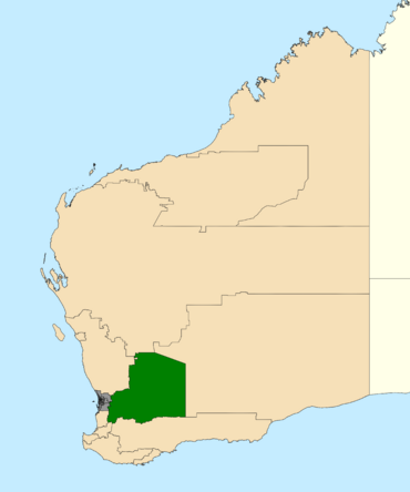
Location of Central Wheatbelt (dark green) in Western Australia
|
|
| State | Western Australia |
| Dates current | 2008–present |
| MP | Mia Davies |
| Party | National |
| Namesake | Wheatbelt region |
| Electors | 25,884 (2021) |
| Area | 102,127 km2 (39,431.5 sq mi) |
| Coordinates | 31°21′S 117°33′E / 31.35°S 117.55°E |
Central Wheatbelt is a special area in Western Australia where people vote for someone to represent them in the state's parliament. This area is called an electoral district.
As its name suggests, this district is right in the middle of Western Australia's important Wheatbelt region. This area is known for growing a lot of wheat and other crops.
Politically, Central Wheatbelt is usually a strong area for the National Party. This means that candidates from the National Party often win the elections here.
Contents
History of Central Wheatbelt's Creation
Central Wheatbelt was first created for the state election in 2008. Before that, there were two other voting areas called Avon and Merredin. These areas were also held by the National Party.
Why the Name Changed
The new Central Wheatbelt district was formed by combining most of the Avon and Merredin areas. About half of the voters in the new district came from each of these older areas.
When the district was first planned, it was going to be called Merredin. However, many people didn't like this idea. Merredin is just one town, and it's only in the eastern part of this very large area. So, they decided to use the name Central Wheatbelt instead. This name better describes the whole region.
Geography of the Central Wheatbelt Area
The Central Wheatbelt district includes many country towns and farms located east of Perth. These areas are mostly rural, meaning they are not big cities.
Towns and Communities in Central Wheatbelt
Some of the towns and communities you can find in Central Wheatbelt include:
- Ballidu
- Beacon
- Beverley
- Dowerin
- Koorda
- Meckering
- Merredin
- Narembeen
- Northam
- Pingelly
- Southern Cross
- Tammin
- Westonia
- Wongan Hills
- Wundowie
- Wyalkatchem
- York
People Who Represent Central Wheatbelt
The people who represent Central Wheatbelt in the Legislative Assembly are called Members. They are elected by the people living in the district.
- Brendon Grylls was the first Member for Central Wheatbelt. He was from the National Party and served from 2008 to 2013.
- Mia Davies became the Member for Central Wheatbelt in 2013. She is also from the National Party and has been representing the district ever since.
Election Results
To see more detailed information about past elections in Central Wheatbelt, you can visit:
 | Kyle Baker |
 | Joseph Yoakum |
 | Laura Wheeler Waring |
 | Henry Ossawa Tanner |

