Merredin, Western Australia facts for kids
Quick facts for kids MerredinWestern Australia |
|||||||||
|---|---|---|---|---|---|---|---|---|---|

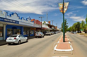
Barrack Street, Merredin, 2013.
|
|||||||||
| Established | 1890s | ||||||||
| Postcode(s) | 6415 | ||||||||
| Elevation | 318 m (1,043 ft) | ||||||||
| Area | [convert: needs a number] | ||||||||
| Location |
|
||||||||
| LGA(s) | Shire of Merredin | ||||||||
| State electorate(s) | Central Wheatbelt | ||||||||
| Federal Division(s) | Durack | ||||||||
|
|||||||||
Merredin /ˈmɛrədɪn/ is a town in Western Australia. It is found in the middle of the Wheatbelt region. Merredin is about halfway between the cities of Perth and Kalgoorlie. You can find it along Great Eastern Highway, which is also known as Route 94.
The town is also on the path of the Goldfields Water Supply Scheme. This means it's part of the Golden Pipeline Heritage Trail. You can travel to Merredin from Perth using the Prospector or MerredinLink train services.
Contents
Exploring Merredin's Past: A Town's Journey
Merredin has a special history. Unlike many other towns in the Wheatbelt, it started as a rest stop. People would stop here on their way to the goldfields. The first European to explore this area was John Septimus Roe in 1836. He was the Surveyor General of Western Australia. He didn't think much of the dry land and low rainfall back then.
Early Days and Sandalwood Cutters
By the 1850s, people were cutting sandalwood in the area. But there wasn't much farming happening yet. The area really began to open up when Assistant Surveyor Charles Cooke Hunt explored it. He traveled through the region between 1864 and 1866.
Hunt saw that the land could be good for raising animals. However, he knew that water would be very important. He named the area Hampton Plains. This was in honor of John Hampton, who was the Governor of Western Australia from 1862 to 1868.
Hunt's Journeys and the Goldfields Road
Hunt made five trips through the Merredin area. His first trip in 1864 was to explore the land. On his second trip in 1865, he created a path that went from one waterhole to another. During his third trip, he built wells and dams. One of these, Hunt's Dam, is about 10 kilometers north of Merredin.
These efforts created a road that later became known as the York to Goldfields road. For a long time, this road was the only way to travel between the coast and the gold towns. It was used until the railway was built.
How Merredin Got Its Name
It's very likely that Hunt climbed Merredin Peak. This large rock is just north of the town. He probably learned the town's name from the local Aboriginal people. Hunt said they called the place "Merriding."
Other ideas suggest the name comes from "merrit-in." This means "the place of the merrit," which is a type of tree used for making spears. Another idea is that it was the Aboriginal name for the "huge bare granite rock" itself. Locals call this Merredin Rock, but its official name is Merredin Peak.
The Arrival of the Railway
In the late 1860s, some large areas of land were leased for farming. But no town formed yet. Even in 1889, there was still no town when Assistant Surveyor Henry King camped near Merredin Rock. The first small settlement was north of Merredin Peak. It was on the York to Goldfields road.
However, this settlement had to move quickly. The railway was built a few kilometers to the south. It couldn't follow the steep hills of Hunt's Road. In 1888, the area east of Merredin was officially declared a goldfield. Over the next ten years, many gold prospectors came through. Gold was found at Coolgardie in 1892 and at Kalgoorlie a year later.
At first, prospectors used Hunt's waterholes road. This meant they passed through where the modern town now stands. In 1893, the narrow-gauge railway reached Merredin. This railway was being built eastwards from Perth. Merredin became important because of a great water collection system on Merredin Peak. The railway was extended from Merredin to Southern Cross in 1894. It reached Kalgoorlie in 1897.
The Railway Dam: A Water Solution
A rock wall was built around Merredin Peak. This wall directed water into a 100-meter channel. The channel then led to a dam that could hold 25 million liters of water. This system collected every drop of rain that fell on the Peak. It sent all the water into the dam. This dam provided water for both the town and the railway.
The entire structure is still there today. You can easily find it at the northern end of town. The Railway Dam was built between 1893 and 1896. It made Merredin much more than just a railway stop.
The Goldfields Water Supply Scheme
The need for water from Merredin Peak changed in 1903. This was when C. Y. O'Connor's 565-kilometer pipeline was finished. This amazing pipeline connected the dry goldfields at Kalgoorlie with plenty of water. The water came from the Helena River east of Perth.
Merredin Peak's Railway Dam continued to supply water to the railway until 1968. Even today, it still provides water for the fountain outside the Merredin Railway Museum and railway station.
Farming and Community Growth
In 1904, the Agricultural Research Station was started in Merredin. This is where the special Bencubbin type of wheat was created. Land in the town was offered for sale in 1906. By 1911, the Merredin Roads Board was formed to manage the area.
A narrow-gauge railway line was built from Merredin to Bruce Rock in 1913. This helped the growing sheep and wheat farming areas of Western Australia. The last part of the Narrogin-Merredin railway was finished in 1915. This completed the link between Merredin and Narrogin.
Eric Hind: A Community Champion
Eric Hind was born in England in 1901. He moved to Western Australia in 1926. He immediately came to the Wheatbelt region. In 1928, he started farming land at Burracoppin. This began his lifelong interest in the Burracoppin area.
During World War II, Eric joined the R.A.A.F. and served overseas. In 1953, he was elected to the Merredin Road Board. He continued to represent the people of Burracoppin on the Merredin Shire Council until 1989. After 36 years of service, the Merredin Shire Council gave Eric a long service award. They also made him a Freeman of the Shire. In 1990, he received the Order of Australia Medal for his community work.
Eric Hind was also a talented violinist. He had earned a music diploma before leaving England. He was an active member of the Merredin Musical Society and Concert Orchestra. Eric often performed as a violinist at events. He also served on the local W.A. Symphony Orchestra Committee. He helped bring many concerts to Merredin over the years. In his honor, the Merredin Shire Council now offers a music scholarship. It is worth $1000.
Merredin's Role in World War II
During World War II, Merredin was home to an important fuel depot. This was called RAAF No.26 Inland Aircraft Fuel Depot (IAFD). It was built in 1942 and closed in 1944. It was located on Cummings Street.
These fuel depots were built across Australia. They stored and supplied aircraft fuel for the RAAF and the US Army Air Corps. There were 31 such depots, costing a total of £900,000 (which is $1,800,000).
Pipeline Pumping Station Number 4
Merredin was also the site of pumping station number 4 for the Goldfields Water Supply Scheme. This station was rebuilt several times over the years.
Merredin's Climate and Environment
Understanding Merredin's Climate
Merredin has a steppe climate. This means it has hot, dry summers and cool, mild winters. It doesn't get a lot of rain.
| Climate data for Merredin | |||||||||||||
|---|---|---|---|---|---|---|---|---|---|---|---|---|---|
| Month | Jan | Feb | Mar | Apr | May | Jun | Jul | Aug | Sep | Oct | Nov | Dec | Year |
| Mean daily maximum °C (°F) | 33.7 (92.7) |
33.0 (91.4) |
30.2 (86.4) |
25.3 (77.5) |
20.6 (69.1) |
17.2 (63.0) |
16.3 (61.3) |
17.2 (63.0) |
20.4 (68.7) |
24.6 (76.3) |
28.4 (83.1) |
31.9 (89.4) |
24.9 (76.8) |
| Mean daily minimum °C (°F) | 17.7 (63.9) |
17.9 (64.2) |
16.1 (61.0) |
12.7 (54.9) |
8.9 (48.0) |
6.8 (44.2) |
5.6 (42.1) |
5.4 (41.7) |
6.7 (44.1) |
9.5 (49.1) |
13.0 (55.4) |
15.7 (60.3) |
11.3 (52.3) |
| Average precipitation mm (inches) | 13.8 (0.54) |
15.6 (0.61) |
20.5 (0.81) |
23.5 (0.93) |
41.2 (1.62) |
50.3 (1.98) |
51.0 (2.01) |
39.0 (1.54) |
25.8 (1.02) |
18.2 (0.72) |
13.9 (0.55) |
13.8 (0.54) |
326.5 (12.85) |
| Average rainy days | 1.7 | 1.7 | 2.5 | 3.1 | 5.7 | 7.9 | 8.6 | 7.4 | 4.8 | 3.5 | 2.3 | 1.7 | 50.9 |
| Source: Australian Bureau of Meteorology | |||||||||||||
Merredin's Economy and Agriculture
The farmland around Merredin is very important. It produces 40% of Western Australia's wheat. Merredin is a central point for the region's farming. Its local co-operative handles over a million tonnes of grain each year. The grain silos near the train facilities are the largest of their kind in the Southern Hemisphere.
Dealing with Salinity Challenges
One big problem for farming in Merredin is salinity. This happens when salty groundwater rises to the surface. It can cause a lot of damage to buildings and roads. A recent study showed that much of this water comes from the town itself. Roads, footpaths, and buildings have replaced native plants. These plants used to soak up all the rainwater.
The problem started in the early 1970s. Since then, farmers and townspeople have been working together. They are trying different programs to improve the soil. They have had some success.
Merredin Aerodrome: A Pilot Training Hub
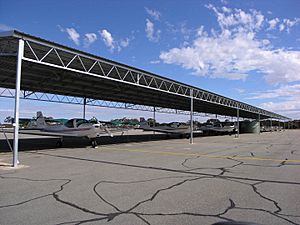
The Merredin aerodrome (airport) was leased for 100 years. It was used by the China Southern West Australian Flying College (CSWAFC). This college is a joint company owned by China Southern Airlines and CAE Inc.. It used Merredin as one of its pilot training places until 2016. The college also operates from Jandakot Airport in Perth.
The Merredin airport was leased for just AU$1. The state government hoped this would bring more investment. The partnership has been successful over the years. The airport now has better runways and other facilities. These include hangars, classrooms, and housing. Even though the college leased the aerodrome, the RFDS and private planes can still use it.
In September 2016, the training school stopped its operations in Merredin. This was because they couldn't find enough experienced staff. Since then, there have been discussions about the lease agreement. The Aerodrome was put up for sale in June 2021.
Travel and Transport in Merredin
Merredin is located on the Eastern Goldfields Railway line.
Merredin is the middle stop for Prospector train. The train stops for 10 minutes, so passengers can stretch their legs. Train staff for the Perth route get off here. They then serve the Prospector train going back to Perth. The same happens for Kalgoorlie staff. Merredin is also the final stop for the Merredinlink train service.
Places to Visit in Merredin
- Mangowine Homestead
- Pioneer Women Memorial Waterfall
Famous People from Merredin
Many notable people were born or grew up in Merredin.
- Tully Bevilaqua – a women's basketball player for the Indiana Fever in the US. She also played for the Canberra Capitals in Australia.
- Hendy Cowan – a former leader of the National Party and a Member of Parliament for Merredin.
- Tony Crook – a former National Party politician. He was a member for O'Connor and an executive officer for the RFDS.
- Jeff Garlett – a former footballer for Swan Districts and Carlton Football Club.
- Geoffrey Gibbs AM – an actor and head of the WA Academy of Performing Arts. He was also Chairman of Trustees for the International Foundation for Arts and Culture.
- Rick Hart – a businessman and public speaker. He was also a former President of the Fremantle Football Club.
- Robert Juniper – a famous landscape artist.
- Ken McAullay – a former WA and East Perth football player. He also played cricket for WA in the Sheffield Shield.
- Laurie Mayne – a former Test cricketer, born in Westonia.
- Don Randall – an Australian Liberal party politician. He was a member for Canning until his death in 2015.
- John Rutherford – the first Western Australian cricketer to play a Test match for Australia.
- Nelly Thomas – won the National Raw Comedy Competition in 2003.
- Nicole Trunfio – won the Australian Search for a Supermodel series in 2003. She then came third in the international version.
- Arthur Upfield – author of the Boney detective series. He worked at Burracoppin.
- Bill Walker OAM – a football player in the WAFL. He won four Sandover Medals. He grew up in the nearby town of Narembeen and went to Merredin Senior High School.
 | Valerie Thomas |
 | Frederick McKinley Jones |
 | George Edward Alcorn Jr. |
 | Thomas Mensah |


