
Narembeen, Western Australia facts for kids
Quick facts for kids NarembeenWestern Australia |
|
|---|---|
.JPG)
Narembeen town clock, 2014
|
|

Narembeen
Location in Western Australia
|
|
| Established | 1922 |
| Postcode(s) | 6369 |
| Elevation | 280 m (919 ft) |
| Area | [convert: needs a number] |
| Location |
|
| LGA(s) | Shire of Narembeen |
| State electorate(s) | Central Wheatbelt |
| Federal Division(s) | Durack |
Narembeen is a town in the Wheatbelt region of Western Australia. It's about 286 kilometers (178 miles) east of Perth, the capital city of Western Australia.
Narembeen is the main town in the Shire of Narembeen. The main jobs here are growing cereal crops like wheat, and raising cattle and sheep. The town is also a big collection point for grain, run by Cooperative Bulk Handling.
The name Narembeen comes from a local Aboriginal language. It means "place of female emus."
Contents
History of Narembeen
Early Exploration and Settlement
The Narembeen area was first explored in 1836 by John Septimus Roe, who was a surveyor. He camped on a rocky hill and saw many emus, so he named the spot Emu Hill.
By the 1850s, European settlers started arriving. They were looking for land to farm and raise animals. People who cut sandalwood trees also visited the area during this time.
Rabbit Proof Fence and New Farmers
In 1901, the famous rabbit proof fence was built just east of Narembeen. You can still see parts of it today!
Around the 1900s, more farmers moved to the area as new land became available. In 1918, the town-site of Emu Hill was officially recognized.
The Rise of Narembeen Town
In 1920, Narembeen was just a small stop along a new railway line that went to Emu Hill. Emu Hill was the biggest community nearby. However, the people of Emu Hill didn't want a hotel built in their town.
Because of this, a lawyer from Perth named Henry Dale and a publican (someone who owns a pub) named Paddy Conlon bought land at the Narembeen railway stop. They planned to build a hotel there.
The town of Narembeen was officially started in 1922. It was about 5 kilometers (3 miles) away from the Emu Hill town-site. The spot chosen for Narembeen wasn't perfect, as it was known to flood sometimes.
Gold Rush and Growth
In 1924, there were rumors of gold being found near the rabbit proof fence. This led to the creation of Holleton, a town about 50 kilometers (31 miles) from Narembeen. Narembeen became important because it was the closest train station to Holleton. It offered transport services to the gold miners.
By 1925, Narembeen had grown a lot, with a population of 2,100 people. Emu Hill eventually faded away.
In 1932, the Wheat Pool of Western Australia announced that Narembeen would get two large grain elevators at its railway siding. These elevators help store and move grain.
Finally, in 1968, the town of Narembeen was officially declared.
Climate in Narembeen
Narembeen has a climate with hot summers and mild winters.
| Climate data for Narembeen | |||||||||||||
|---|---|---|---|---|---|---|---|---|---|---|---|---|---|
| Month | Jan | Feb | Mar | Apr | May | Jun | Jul | Aug | Sep | Oct | Nov | Dec | Year |
| Record high °C (°F) | 45.8 (114.4) |
47.1 (116.8) |
41.7 (107.1) |
37.6 (99.7) |
33.6 (92.5) |
25.9 (78.6) |
24.7 (76.5) |
30.7 (87.3) |
34.0 (93.2) |
37.0 (98.6) |
42.2 (108.0) |
44.4 (111.9) |
47.1 (116.8) |
| Mean daily maximum °C (°F) | 34.0 (93.2) |
33.1 (91.6) |
30.3 (86.5) |
25.9 (78.6) |
21.0 (69.8) |
17.5 (63.5) |
16.5 (61.7) |
17.6 (63.7) |
20.4 (68.7) |
25.0 (77.0) |
28.5 (83.3) |
31.9 (89.4) |
25.1 (77.2) |
| Mean daily minimum °C (°F) | 16.6 (61.9) |
16.9 (62.4) |
14.8 (58.6) |
12.0 (53.6) |
8.2 (46.8) |
6.4 (43.5) |
5.4 (41.7) |
5.2 (41.4) |
6.1 (43.0) |
9.0 (48.2) |
12.2 (54.0) |
14.5 (58.1) |
10.6 (51.1) |
| Record low °C (°F) | 8.5 (47.3) |
7.6 (45.7) |
5.6 (42.1) |
2.8 (37.0) |
−1.8 (28.8) |
−2.2 (28.0) |
−3.2 (26.2) |
−1.8 (28.8) |
−1.5 (29.3) |
0.7 (33.3) |
1.4 (34.5) |
4.4 (39.9) |
−3.2 (26.2) |
| Average precipitation mm (inches) | 16.3 (0.64) |
17.7 (0.70) |
20.1 (0.79) |
23.0 (0.91) |
39.5 (1.56) |
51.7 (2.04) |
49.9 (1.96) |
41.5 (1.63) |
26.2 (1.03) |
19.2 (0.76) |
16.5 (0.65) |
13.0 (0.51) |
334.6 (13.17) |
| Average precipitation days | 2.2 | 2.4 | 3.2 | 5.0 | 7.7 | 10.8 | 12.0 | 10.5 | 7.5 | 5.1 | 3.7 | 2.5 | 72.6 |
Images for kids
-
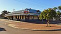
Narembeen Hotel, 2014
-
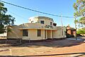
Narembeen Public Hall, 2014
-
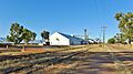
Narembeen grain receival point, 2014


