Cook's Landing Place, Town of Seventeen Seventy facts for kids
Quick facts for kids Captain Cook's Landing Place, Town of Seventeen Seventy |
|
|---|---|

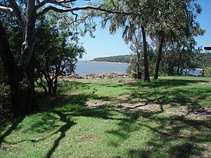
Site of Cook's landing in 1770
|
|
| Location | Seventeen Seventy, Gladstone Region, Queensland, Australia |
| Design period | pre 1824 (pre-convict settlement) |
| Built | 1770 May 24 - 1770 May 24 |
| Official name: Cook's Landing Place, Town of Seventeen Seventy | |
| Type | state heritage (landscape) |
| Designated | 27 March 1996 |
| Reference no. | 601614 |
| Significant period | 1770 (historical) |
| Significant components | natural landscape, memorial - cairn |
| Lua error in Module:Location_map at line 420: attempt to index field 'wikibase' (a nil value). | |
Captain Cook's Landing Place is a special historical spot in Seventeen Seventy, Queensland, Australia. It's named after Captain Cook, who first landed there on May 24, 1770. This place is listed on the Queensland Heritage Register because of its important history.
Contents
Exploring Captain Cook's Landing Site
The town of Seventeen Seventy got its name from a very important event. On May 24, 1770, Lieutenant James Cook, captain of the ship HMS Endeavour, came ashore. He landed on the beach of Round Hill Creek, right where the village is today.
Cook's First Landing in Queensland
On that Thursday morning in May 1770, Captain Cook came to shore. He was in a small boat called a pinnace. With him were Mr. Joseph Banks, a famous botanist, and Dr. Daniel Solander. Another officer, Second Lieutenant John Gore, was in a yawl (another small boat). This was their first landing in what is now Queensland. It was also their second landing in Australia. Cook made eleven landings along Australia's eastern coast. Ten of these were in Queensland. His landing spot was near the current caravan park. A small stream there flows into the beach.
What Cook and Banks Saw
Captain Cook described the land as "visibly worse" than Botany Bay. The soil was dry and sandy. The woods had few plants growing under the trees. He saw many "birch" trees, which were likely coastal ironbark trees. Mangroves grew along the edges of the lagoon. Palm trees were found in low, sandy areas. Cook also noted bustards (a type of bird), black and white ducks, and various shellfish. These included small oysters, mussels, pearl oysters, and cockles.
Joseph Banks, the botanist, explored the woods with Cook. He noticed many different types of plants, even though the plant cover was not thick. He recognized some plants he had seen in the Tropics. Banks also described many birds, including a species of Bustard. He collected 55 plant samples from the area. Some of these were drawn and described in Banks' Florilegium. This book was created from sketches by Parkinson, who sadly died on the way home. Because these woods were where the first plant samples from Queensland were collected, they are very important for science. This led to the creation of Joseph Banks Environmental Park in 1989.
Later Explorers and Settlement
In 1802, Matthew Flinders visited the area in his ship, HM sloop Investigator. He was with the Lady Nelson. They reached Round Hill Head on August 2. They anchored almost in the same spot where Cook's Endeavour had been in 1770. Other early sailors also visited Bustard Bay. They often noted Round Hill as an important landmark.
Most European settlers did not come to Bustard Bay directly. However, farms were set up further inland. In 1867, a lighthouse was built at Bustard Head. This was because more ships were sailing along the coast. A sawmill also started at Eurimbula Creek. By 1894, Agnes Water beach was a popular place for sawmill workers to visit on weekends. Timber was moved down Round Hill. Pine logs were taken by teams of horses to rafting areas on Oyster Creek and Round Hill Creek. The first small house at Round Hill was built in 1915.
Remembering Cook's Landing
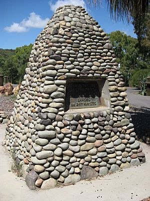
In 1925, the Royal Geographical Society of Queensland decided to build a monument. It would be at Bustard Bay to remember the first British landing on the Queensland coast. They asked for public donations, and people gave a lot of money. A stone monument, called a cairn, was built in early 1926. It stands on the point of land looking out over Bustard Bay. In 1927, a large area of land around the monument was set aside as a Recreation Reserve. This land was managed by the Miriam Vale Shire. However, this area did not include the exact spot where Cook landed.
In the mid-1930s, a town was planned near Round Hill Creek. It was named Seventeen Seventy. This name was chosen to highlight that it was Cook's first landing place in Queensland in May 1770. For the 1970 Bi-Centenary Celebrations (200 years since Cook's landing), another monument was planned. The Queensland Government provided money for it. This new monument was meant to show that Cook's landing opened up opportunities in Queensland. A concrete archway was built with the words "Doorway to Destiny" on top. This monument was later taken down in 1994 because of damage.
In 1989, the Joseph Banks Environmental Park was officially created. It covers about 114 hectares. This park helps protect the important natural area that Joseph Banks explored.
What the Landing Place Looks Like
Round Hill Head is a special granite landform. It is 54 meters above sea level. Sailors use it as a landmark. It marks the northwest end of Hervey Bay. The headland has natural grassy areas. These run from the ocean on the east to the calm creek on the west. This grassy area has been called "Mrs Cook's Drive" for a long time.
Round Hill Creek is on the western side of the headland. It has a very narrow channel. This channel has kept its depth since 1770. However, there are shifting sandbanks. The sandy beach has mangroves along its edge. Behind them are cottonwood trees, paperbark trees, and palms in wetter areas. Ironbark trees grow on the drier slopes.
From Monument Point, you can see beautiful views. You can see the inlet with boats. You can also see distant blue mountains. Across the sand to the west, there is thick lowland vegetation. This is part of Eurimbula National Park. The jagged Munro Range stands tall in the distance. At night, the Bustard Head lighthouse flashes its light across Bustard Bay.
Most of the recent houses do not spoil the natural look of the area. Many old trees have been kept. The bush has grown back on the lower slopes. Very few groups of mangroves remain along Round Hill Creek. The caravan park, built in 1978, has many old native trees. The land along the foreshore has impressive tall Cabbage palms. These trees were probably there before Cook landed.
A spring used to feed a small stream. This stream flowed onto the beach. It only stopped flowing in 1992. In 1989, it could fill a bucket of water every 25 seconds. This was likely the stream Captain Cook mentioned. The nearby houses and caravan park now have a sewer system. This helps prevent pollution of the groundwater.
The road area still has its natural plants. The picnic area near the shop is shady and nice. The marina and boat ramp are not too noticeable. However, the entrance to the town can look a bit messy. This is despite driving through tall forest just before entering Seventeen Seventy. The upper parts of Round Hill Creek are winding and shallow. They are lined with mangroves and backed by tall paperbark forests.
Heritage listing
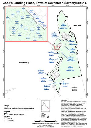
Cook's Landing Place was officially added to the Queensland Heritage Register on March 27, 1996.


