Coonoor facts for kids
Quick facts for kids
Coonoor
Kunnur
|
|
|---|---|
|
Hill Station
|
|

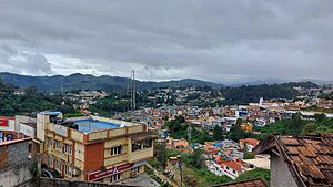
The view of Coonoor from Grey's Hill.
|
|
| Country | |
| State | Tamil Nadu |
| District | Nilgiris |
| Government | |
| • Type | Municipality |
| • Body | Coonoor Municipality |
| Elevation | 1,650 m (5,410 ft) |
| Population
(2011)
|
|
| • Total | 45,954 |
| Languages | |
| • Official | Tamil |
| Time zone | UTC+5:30 (IST) |
| PIN |
643 10x
|
| Telephone code | 91(0)423 |
| Vehicle registration | TN-43 |
Coonoor is a lovely town located in the Nilgiris district of Tamil Nadu, India. It's known as a "hill station," which means it's a town in the mountains, often a popular place for holidays.
Coonoor sits on the edge of the Nilgiri plateau. It's also at the start of the Coonoor Ghat, which is the main road connecting the Nilgiris mountains to the flat lands below. The town is about 19 kilometers (12 miles) from Ooty, another famous hill station. Coonoor is built in a beautiful valley called Jackatalla, surrounded by green, wooded hills.
Contents
About Coonoor
Coonoor is a special kind of town called a taluk and a municipal town. This means it's a local area with its own government that helps manage the town. In 2011, about 45,494 people lived here.
A Look Back: History
Coonoor has been an important place since the time of British rule in India. It was the end point for a railway line that connected the Nilgiri mountains to other parts of India. This made it easier for people and goods to travel.
In the past, Coonoor had many important buildings. These included a court, a hospital, churches, schools, and a library. There were also shops and hotels, especially for European visitors. Coonoor was one of the main hill stations in the area, second only to Ooty. It was a popular spot because of its natural beauty.
The European people often lived on the higher parts of the plateau. The local people lived on the lower slopes of the valley.
Who Lives Here?
| Religion | ||||
|---|---|---|---|---|
| Religion | Percent(%) | |||
| Hindu | 61.81% | |||
| Christian | 23.99% | |||
| Muslim | 13.01% | |||
| Other | 1.19% | |||
According to the 2011 census, Coonoor had a population of 45,494 people. There were more females than males, with about 1,058 females for every 1,000 males. This is higher than the average for India.
About 3,768 children under the age of six lived in Coonoor at that time. Most people in the city could read and write, with an average literacy rate of 84.79%. This is also higher than the national average.
The people of Coonoor follow different religions. The largest group is Hindus, making up about 61.81% of the population. Christians are the next largest group at 23.99%, followed by Muslims at 13.01%. A small number of people follow other religions or no religion.
Fun Things to Do: Tourism
Coonoor is a great place to visit, with several interesting spots for tourists.
Sim's Park
This is a large botanical garden that covers 12 hectares (about 30 acres). It has more than 1,000 different kinds of plants! Part of the garden is designed in a Japanese style. It was named after J. D. Sim, who was important in the Madras Club in 1874. A big event here is the annual fruit show, which happens every May.
Amazing Viewpoints
- Dolphin's Nose Viewpoint: This spot is about 10 kilometers (6 miles) from Coonoor. It offers amazing views of the surrounding hills and valleys. You can even hike there from another spot called Lady Canning's Seat.
- Lamb's Rock: About 5.5 kilometers (3.4 miles) from Coonoor, Lamb's Rock is another fantastic viewpoint. It gives you wide, open views of the beautiful landscape.
Coonoor's Climate and Location
Coonoor is located at coordinates 11°20′42″N 76°47′42″E / 11.345°N 76.795°E. It sits at an average height of 1,650 meters (5,413 feet) above sea level. Because it's so high up, Coonoor has a special kind of weather called a sub-tropical highland climate. This means it's generally cool and pleasant, not too hot or too cold.
| Climate data for Coonoor (1981–2010, extremes 1928–2012) | |||||||||||||
|---|---|---|---|---|---|---|---|---|---|---|---|---|---|
| Month | Jan | Feb | Mar | Apr | May | Jun | Jul | Aug | Sep | Oct | Nov | Dec | Year |
| Record high °C (°F) | 25.6 (78.1) |
27.0 (80.6) |
28.3 (82.9) |
29.6 (85.3) |
29.4 (84.9) |
28.6 (83.5) |
26.2 (79.2) |
26.2 (79.2) |
25.1 (77.2) |
25.6 (78.1) |
25.2 (77.4) |
25.6 (78.1) |
29.6 (85.3) |
| Mean daily maximum °C (°F) | 20.2 (68.4) |
21.7 (71.1) |
23.6 (74.5) |
24.7 (76.5) |
25.2 (77.4) |
23.0 (73.4) |
22.2 (72.0) |
22.1 (71.8) |
22.1 (71.8) |
21.3 (70.3) |
20.0 (68.0) |
19.6 (67.3) |
22.1 (71.8) |
| Mean daily minimum °C (°F) | 9.3 (48.7) |
10.4 (50.7) |
12.4 (54.3) |
14.4 (57.9) |
15.3 (59.5) |
15.3 (59.5) |
14.8 (58.6) |
14.9 (58.8) |
14.1 (57.4) |
13.4 (56.1) |
11.8 (53.2) |
10.4 (50.7) |
13.1 (55.6) |
| Record low °C (°F) | 0.7 (33.3) |
0.2 (32.4) |
3.8 (38.8) |
8.4 (47.1) |
9.0 (48.2) |
9.4 (48.9) |
8.8 (47.8) |
8.6 (47.5) |
7.2 (45.0) |
6.1 (43.0) |
3.0 (37.4) |
−0.5 (31.1) |
−0.5 (31.1) |
| Average rainfall mm (inches) | 52.4 (2.06) |
56.9 (2.24) |
111.6 (4.39) |
109.9 (4.33) |
85.7 (3.37) |
61.3 (2.41) |
79.5 (3.13) |
89.0 (3.50) |
148.9 (5.86) |
309.3 (12.18) |
296.2 (11.66) |
180.0 (7.09) |
1,590.7 (62.63) |
| Average rainy days | 2.3 | 2.4 | 3.4 | 5.9 | 7.0 | 6.0 | 7.9 | 8.2 | 9.5 | 13.7 | 10.4 | 7.5 | 84.4 |
| Average relative humidity (%) (at 8:30 IST) | 64 | 63 | 56 | 64 | 63 | 70 | 74 | 73 | 73 | 78 | 79 | 74 | 69 |
| Source: India Meteorological Department | |||||||||||||
Gallery
See also
 In Spanish: Coonoor para niños
 | James B. Knighten |
 | Azellia White |
 | Willa Brown |


