Cora, West Virginia facts for kids
Quick facts for kids
Cora, West Virginia
|
|
|---|---|

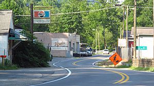
Old US Highway 119 in Cora
|
|
| Country | United States |
| State | West Virginia |
| County | Logan |
| Elevation | 738 ft (225 m) |
| Time zone | UTC-5 (Eastern (EST)) |
| • Summer (DST) | UTC-4 (EDT) |
| ZIP code |
25614
|
| Area code(s) | 304 & 681 |
| GNIS feature ID | 1554190 |
Cora is a small place located in Logan County, West Virginia, in the United States. It is known as an unincorporated community. This means it's a neighborhood or area that doesn't have its own local government, like a city or town would. Instead, it's managed by the larger county.
Cora is situated about 2 miles (3.2 km) southwest of a bigger town called Logan. It sits right along a stream named Copperas Mine Fork. The community has its own post office with a special mail code, ZIP code 25614. Cora is also part of a larger area called Mount Gay-Shamrock. This is a census-designated place, which means it's an area defined by the government for counting people and gathering information.
What's the Weather Like in Cora?
The weather in Cora usually has hot and humid summers. The winters are generally mild, meaning they are not too cold. This type of weather is called a humid subtropical climate. On climate maps, you might see it labeled as "Cfa". This climate typically brings plenty of rain throughout the year.
See also
 In Spanish: Cora (Virginia Occidental) para niños
 | Kyle Baker |
 | Joseph Yoakum |
 | Laura Wheeler Waring |
 | Henry Ossawa Tanner |


