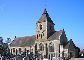
Coulonces, Calvados facts for kids
Quick facts for kids
Coulonces
|
|
|---|---|
|
Part of Vire Normandie
|
|

Saint-Gilles
|
|
| Country | France |
| Region | Normandy |
| Department | Calvados |
| Arrondissement | Vire |
| Canton | Vire Normandie |
| Commune | Vire Normandie |
| Area
1
|
15.58 km2 (6.02 sq mi) |
| Population
(2019)
|
730 |
| • Density | 46.9/km2 (121.4/sq mi) |
| Time zone | UTC+01:00 (CET) |
| • Summer (DST) | UTC+02:00 (CEST) |
| Postal code |
14500
|
| Elevation | 84–196 m (276–643 ft) (avg. 87 m or 285 ft) |
| 1 French Land Register data, which excludes lakes, ponds, glaciers > 1 km2 (0.386 sq mi or 247 acres) and river estuaries. | |
Coulonces was a small village in northwestern France. It was located in the Calvados area, which is part of the Normandy region.
On January 1, 2016, Coulonces joined with other nearby villages. They all became part of a new, larger town called Vire Normandie.
Where is Coulonces Located?
Coulonces is situated by the Brévogne River. This area is known as the Bocage Virois. It features a landscape of woodlands and fields.
The village is about 4 kilometers (2.5 miles) southwest of La Graverie. It is also 5 kilometers (3 miles) northwest of Vire. Saint-Sever-Calvados is about 12 kilometers (7.5 miles) to the east.
The highest point in Coulonces is 196 meters (643 feet) above sea level. This high point is found in the southwestern part of the area. The lowest point is 84 meters (276 feet) high. It is located in the northeast.
How Many People Lived There?
The number of people living in Coulonces changed over the years. Here is a look at its population history:
| Historical population | ||
|---|---|---|
| Year | Pop. | ±% |
| 1962 | 594 | — |
| 1968 | 556 | −6.4% |
| 1975 | 503 | −9.5% |
| 1982 | 608 | +20.9% |
| 1990 | 636 | +4.6% |
| 1999 | 650 | +2.2% |
| 2008 | 697 | +7.2% |
See also
 In Spanish: Coulonces (Calvados) para niños
 | Laphonza Butler |
 | Daisy Bates |
 | Elizabeth Piper Ensley |


