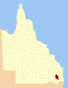
County of Aubigny facts for kids
Quick facts for kids AubignyQueensland |
|||||||||||||||
|---|---|---|---|---|---|---|---|---|---|---|---|---|---|---|---|

Location within Queensland
|
|||||||||||||||
|
|||||||||||||||
The County of Aubigny is a special kind of area in Queensland, Australia. Think of it like an old-fashioned way to divide up land. It's called a cadastral division, which means it's used mainly for keeping track of who owns what land, not for everyday government or voting.
This county is located between 151°E and 152°E longitude. It covers parts of the Toowoomba Region and the Dalby area within the Western Downs Region.
What is a County?
A county in Queensland is a bit different from counties you might know in other places. Here, it's not a place with its own local government or a mayor. Instead, it's a way to organize land records. Imagine a big map where each county is a section, helping people find and register land ownership. It's a system that has been around for a long time!
The Story Behind the Name
The name Aubigny was chosen by the Surveyor-General of New South Wales back in 1850. It's thought that the name might have been picked to honor the Earl of Arundel. This Earl had a long connection with the name Aubigny, which has a rich history. The area officially got its name and boundaries on March 7, 1901. This happened under the Land Act 1897, with approval from the Governor in Council.
Parishes: Smaller Land Sections
Just like a county is a larger land division, it's also divided into smaller parts called parishes. These parishes are even smaller sections of land within the county. They help make the land registration system even more organized. For example, some parishes in the County of Aubigny include places like Beauaraba, Dalby, and Toowoomba. Each parish helps identify specific locations for land records.

