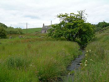
Cowton Burn facts for kids
Quick facts for kids Cowton Burn |
|
|---|---|

Cowton Burn
|
|
| Country | Scotland |
| Physical characteristics | |
| Main source | Mounth (eastern Grampian Mountains) |
| River mouth | Cowie Water 56°59′23″N 2°15′59″W / 56.98961°N 2.26636°W |
Cowton Burn is a small stream in Scotland. It starts high up in the Mounth, which is part of the eastern Grampian Mountains. The stream begins on the slopes of Durris Forest, west of a place called Netherley, Aberdeenshire. Cowton Burn flows into another stream called the Cowie Water. You can see the A957 road crossing over Cowton Burn near Rickarton House.
Where Cowton Burn Starts and Flows
The Cowton Burn begins in a conifer forest area within the Durris Forest. This means it starts among trees like pine and fir. From its source, the stream flows downhill towards the east. It continues its journey until it joins the Cowie Water.
- The stream is usually surrounded by lots of green plants.
- These plants grow right up to the edges of the water.
A Look at History Near Cowton Burn
The area around Cowton Burn has an interesting past.
- A very old Roman Camp called Raedykes was once located on the higher ground to the north of the stream's central area.
- Some historians think that a famous battle, the Battle of Mons Graupius, might have happened in or near the Cowton Burn area. This battle was fought a long time ago.
- If you look downstream where Cowton Burn meets the Cowie Water, you can see parts of Fetteresso Forest to the west.
- Close to this forest is the Rickarton House estate. This estate was started by Colonel William Rickart Hepburn in the early 1800s.
Black History Month on Kiddle
Famous African-American Artists:
 | Delilah Pierce |
 | Gordon Parks |
 | Augusta Savage |
 | Charles Ethan Porter |

All content from Kiddle encyclopedia articles (including the article images and facts) can be freely used under Attribution-ShareAlike license, unless stated otherwise. Cite this article:
Cowton Burn Facts for Kids. Kiddle Encyclopedia.
